 Abraham Lincoln
If given the truth, the people can be depended upon to meet any national crisis...
 Guildford news...
for Guildford people, brought to you by Guildford reporters - Guildford's own news service
Where Is This? No.119
Published on: 23 Jul, 2014
Updated on: 23 Jul, 2014
By David Rose
The black and white photo from 1987 featured last week showing effects of the Great Storm in Stoke Park was easily identified by a number of readers. If you stand in the same spot today you can see the Spectrum leisure centre in the distance.
Last week’s quirky photo showed the Weston Chapel of Holy Trinity Church in Guildford High Street. Most got that one with plenty of additional information supplied. Click here to see last week’s post and the replies at the foot of it.
Ray Springer has added some memories of the Great Storm, and in mentioning Stoke Park’s Peacock Wood, Chris Townend wonders whatever happened to the peacocks? Can anyone supply a answer?
In a reply added to Where Is This No.117 Dave Middleton notes the hazard motorists used to have when you could turn off the A3 up Stag Hill on to the A31 towards the Hog’s Back. He also adds another theory to the gypsy curse bridge, and that it’s the newer one and not the one I had in mind. I think he is correct.
On to this week’s pair of images.
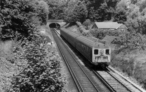
Here is the vintage photo that shows one of the old style electric trains just to the south of Guildford. Can you name the location? And if so perhaps the bridge the photo was taken from and the one in the distance and to where the road on it leads to? Tunnel vision is not required. Train details from our railway experts will also be welcomed.
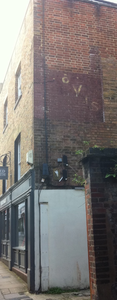
The quirky photo is of a ‘ghost sign’ – one of those fading painted signs from a bygone era, this one on a building in a side street in Guildford town centre.
Have you seen this one that I think reads ‘HOVIS’? Any ideas in which street it can be found and perhaps to which bakery it was connected with?
If you know the answers, please leave a reply in the box below. Replies will be published at about the same time next week along with the next pair of images.
Responses to Where Is This? No.119
Leave a Comment Cancel replyPlease see our comments policy. All comments are moderated and may take time to appear. Full names, or at least initial and surname, must be given.
Recent Articles
- Letter: Happy New Year
- Mole Valley Best Place to Live in the South East
- ‘Truly Inspiring’ Musical Event Brings Generations Together
- Opinion: Why Are Five-storey Blocks Allowed in An Area of Outstanding Natural Beauty?
- Guildford to Gatwick Line to Close for Two Weeks for Critical Upgrades
- Football Pitches Approved as Part of Secretts Redevelopment
- Witness Appeal Following Serious Collision
- City Maintain Winning Form
- Council and Guildford High School Join Forces to Help Local Families over Christmas
- Flashback: Closure Order Issued On Troubled Flat In Stoughton


Recent Comments
- John Hawthorne on Letter: A Surge of Discontent Calls for Accountability and Change
- Olly Azad on City Maintain Winning Form
- David Jackson on Where Is This? No. 51
- Brian Creese on Letter: A Surge of Discontent Calls for Accountability and Change
- Derek Payne on Letter: Guildford Can’t Be Trusted with E-Bikes for Hire
- Elle Hepburn on Student Named Land Based and Horticulture Learner of the Year
Search in Site
Media Gallery
Dragon Interview: Local Artist Leaves Her Mark At One of England’s Most Historic Buildings
January 21, 2023 / No Comment / Read MoreDragon Interview: Lib Dem Planning Chair: ‘Current Policy Doesn’t Work for Local People’
January 19, 2023 / No Comment / Read MoreA3 Tunnel in Guildford ‘Necessary’ for New Homes, Says Guildford’s MP
January 10, 2023 / No Comment / Read More‘Madness’ for London Road Scheme to Go Ahead Against ‘Huge Opposition’, Says SCC Leader
January 6, 2023 / No Comment / Read MoreCouncillor’s Son Starts Campaign for More Consultation on North Street Plan
December 30, 2022 / No Comment / Read MoreCounty Council Climbs Down Over London Road Works – Further ‘Engagement’ Period Announced
December 14, 2022 / No Comment / Read MoreDragon Interview: GBC Reaction to the Government’s Expected Decision to Relax Housing Targets
December 7, 2022 / No Comment / Read MoreHow Can Our Town Centre Businesses Recover? Watch the Shop Front Debate
May 18, 2020 / No Comment / Read More


John Lomas
July 24, 2014 at 1:42 pm
The railway photo was taken from Ferry Lane, the bridge in the distance is the drive for Langton Priory [formerly Weycliffe (House)].
The southern portal of the northern tunnel is actually visible through the bridge arch.
The photo is post nationalisation as the headcode 73 shows a Waterloo to Portsmouth & Southsea (slow) via Worplesdon.
The building in the middle distance appears to be shown as a modifiedL shape on the ’72 OS so I would put the date during the mid to late 60’s as the distant signal for the Shalford junction is no longer visible about halfway between the two bridges, thoughit is just possible that the rodding is stll there, just to the right of the train.
David Bennett
July 24, 2014 at 1:42 pm
The first photo appears to be taken from the bridge in Ferry Lane, St Catherine’s, looking towards the “Chalk Tunnel”.
The second picture is of an old advertisement on the wall of a shop in Chapel Street, in the yard at the back of Gap. My great aunt and uncle ran a small family bakery from these premises during and after the war. I remember visiting the shop as a boy in the 1950’s and being fascinated by the large golden cash register on the counter. I believe they retired from the bakery in the late fifties or early sixties. They lived in a large flat above one of the nearby High Street Shops. This flat had a huge window looking down over the High Street where I remember having a great view of the carnival procession celebrating the Queen’s Coronation!
Chris Townsend
July 27, 2014 at 8:34 pm
My tentative guess is that the vintage photo shows a section of line between the two tunnels, perhaps looking south towards the bridge at Ferry Lane.
The ghost sign is on the wall of what was until the 1980s Gwinn’s, in Chapel Street. The baker’s was founded there in the 1830s.
Brian Holt
July 28, 2014 at 4:22 pm
(1) This photo was taken from Ferry Lane bridge, the train (headcode number 73) on the front shows it was a stopping train to Portsmouth. The two tunnels south of Guildford station are known as the chalk tunnel and the sand (or St Catherine’s) tunnel.
The London & South Western Railway had few lengthy tunnels, and the chalk tunnel at 845 yards, is the longest on the electrified lines from London Waterloo. It was originally longer at 968 yards, but the northern end was excavated out. The portals are quite plain but there are remains of an overbridge immediately in front of the north portal. The up line is bi-directional between Guildford station and Shalford Junction, hence speed restriction signs for both tracks.
Part of St Catherine’s tunnel collapsed in 1895, apparently because of percolation of water from a burst water main. About 1,000 tons of debris fell onto the line, narrowly missing a train. A coach house stables over the tunnel fell into a hole 48 feet wide and about 18 feet deep. The tunnel was extended at its north end in 1984, in order to provide additional support for unstable ground above. The new section comprises concrete sections on brick abutments, despite this work the length of the tunnel is still quoted officially as 132 yards.
(2) This Hovis sign on the wall is in Chapel Street. In the 1940s West’s Bakery was there. Behind their shop, the bakery was later demolished. Dragon reader Peter Bullen had the shop and sold old postcards. Today it is the Fired Earth tile shop.
When I was small, Read’s butcher shop was next door, then Gwinn’s bread & grocery shop. At the end of the road, next to the Conservative Club, was Horsecroft’s fish and chip shop.
Doug and Bill Stanniforth
July 28, 2014 at 4:27 pm
The first photo is of the cutting between the two tunnels on the Portsmouth line just south of Guildford. The photo was taken from the bridge on Ferry Lane, this lane is famous as it is near the Dragon editor’s house.
I’ll bet he rolls his speedboat out of his house and down the hill into the river at the bottom.
The second photo is in Chapel Street, the shop is Fired Earth.
Come to think of it, I might consider a speedboat. The running costs might be less than my bike recently. Ed
Peter Holt
July 28, 2014 at 6:11 pm
Photo was taken from Ferry Lane Bridge near St Catherine’s tunnel (also called The Sand Tunnel). The train has just come out of The Chalk Tunnel and is a stopping service to Portsmouth (where you can buy speedboats).
The bridge in the back ground has no name but it goes to QDS Environmental Ltd [aka Langton Priory]. All railway bridges in the UK have numbers. Difficult to identify the train from the photo, but I believe it to be a 4-sub unit.
The units were known as “Sheba’s (“The Queen of Sheba came with a very great train”). The section of track between the two tunnels was controlled from Guildford South signal box.
My chauffeur informs me that photo 2 is in Chapel Street and was once West Bakers.
Perhaps your chauffeur can drive you to Portsmouth. Why not take take the Laughing Tandem Brothers with you and start a “Speedboat Dreamers” club? After all, Portsmouth is a good way away. Ed
Chaz Folkes
July 29, 2014 at 10:45 am
I believe that the bridge the first picture is taken from is on Ferry Lane with the second tunnel under St Catherine’s hill just behind the photographer. The bridge in the background is on a road coming off the Portsmouth Road just opposite the Register Office.
The second picture is of Chapel Street in the centre of town.
Brian Holt
July 30, 2014 at 12:12 am
Gwinn’s shop did not have a end wall because it was in a row of shops. I used to go there for my mother’s shopping when she run out of something. We lived nearby in Quarry Street.
West’s shop was on the end with the small bakery behind that is why there is a space there now. They also had a son who went to school with my brother.
Dave Peters
August 30, 2014 at 4:05 pm
The train is a BIL/HAL set – the usual for these services then.