 Abraham Lincoln
If given the truth, the people can be depended upon to meet any national crisis...
 Guildford news...
for Guildford people, brought to you by Guildford reporters - Guildford's own news service
Where Is This? No.83
Published on: 13 Nov, 2013
Updated on: 13 Nov, 2013
By David Rose
Thanks again to all those who replied to last week’s images. Click here to see their replies at the foot of the post.
Most recognised the part of the High Street that is where White Lion Walk is today. In the old photo the Lion Hotel can be seen along with the Astolat Tea Rooms.
Carol Norris’ comments were very interesting about the different coloured uniforms worn by the staff at the two Astolat tea shops. Today’s Starbucks and the like take note!
I think some readers may have been canny and used Google Street View to work out where the topiary is. It’s Cheseldon Road. So well done.
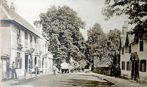
This week’s vintage photo is a view of part of a village close to Guildford town centre. The pub on the left still stands and so do the cottages on the right. A church is hidden behind the trees. Any ideas or comments? And does anyone know about the connection here with the World War II GHQ Stopline?
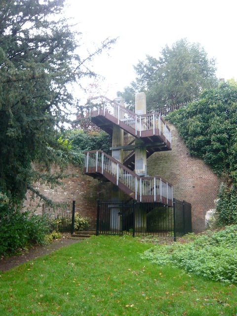
The photo of something quirky was taken by editor Martin Giles recently. A flight of steps that leads down from one public open space (a garden) to another and quite close to the town centre.
If you know the answers to this week’s, and perhaps have some comments to make, please leave a reply in the box below. All replies will be posted at about the same time next week, along with a new post with the answers to this week’s vintage photo and quirky picture, and the next pair of images.
Responses to Where Is This? No.83
Leave a Comment Cancel replyPlease see our comments policy. All comments are moderated and may take time to appear. Full names, or at least initial and surname, must be given.
Recent Articles
- Burglar Jailed Thanks To Quick Action of Ash Resident
- Highways Bulletin for December
- Birdwatcher’s Diary No.318 Some Pre-Christmas Rambles
- Merry Christmas and a Happy New Year to All Our Contributors and Readers!
- More Units Added to Solums’s Station Redevelopment
- Vehicle Stop on Epsom Road Leads to Prolific Drug Gang Being Put Behind Bars
- Local Political Leaders Respond to Publication of the English Devolution White Paper
- Flashback: Guildford All Lit Up For Christmas – Then And Now
- City Earn Themselves a Three Point Christmas Present
- Mayor’s Diary: December 23 – January 4


Recent Comments
- Aubrey Leahy on Vehicle Stop on Epsom Road Leads to Prolific Drug Gang Being Put Behind Bars
- Sheila Newton on Memories of the Dennis Bros Christmas Party
- John Perkins on Two Unitary Authorities, One Elected Mayor – Most Likely Devolution Outcome for Surrey
- Gavin Morgan on Merry Christmas and a Happy New Year to All Our Contributors and Readers!
- David Roberts on Local Political Leaders Respond to Publication of the English Devolution White Paper
- Steve Grove on Merry Christmas and a Happy New Year to All Our Contributors and Readers!
Search in Site
Media Gallery
Dragon Interview: Local Artist Leaves Her Mark At One of England’s Most Historic Buildings
January 21, 2023 / No Comment / Read MoreDragon Interview: Lib Dem Planning Chair: ‘Current Policy Doesn’t Work for Local People’
January 19, 2023 / No Comment / Read MoreA3 Tunnel in Guildford ‘Necessary’ for New Homes, Says Guildford’s MP
January 10, 2023 / No Comment / Read More‘Madness’ for London Road Scheme to Go Ahead Against ‘Huge Opposition’, Says SCC Leader
January 6, 2023 / No Comment / Read MoreCouncillor’s Son Starts Campaign for More Consultation on North Street Plan
December 30, 2022 / No Comment / Read MoreCounty Council Climbs Down Over London Road Works – Further ‘Engagement’ Period Announced
December 14, 2022 / No Comment / Read MoreDragon Interview: GBC Reaction to the Government’s Expected Decision to Relax Housing Targets
December 7, 2022 / No Comment / Read MoreHow Can Our Town Centre Businesses Recover? Watch the Shop Front Debate
May 18, 2020 / No Comment / Read More


Ewan Gordon
November 14, 2013 at 5:03 pm
1. The Seahorse at Shalford.
2. Sorry no idea on those steps.
Ray Springer
November 14, 2013 at 9:03 pm
The picture is of Shalford and the pub on the left is the Sea Horse. St. Mary’s Church is hidden by the trees.
The staircase is in Racks Close, behind the Castle.
Carol Norris
November 17, 2013 at 1:58 pm
Picture 1 : Shalford
Colin & Linda Jackson
November 17, 2013 at 5:56 pm
We think the first photo is of Shalford and the pub is the Seahorse. There is a slot in the concrete wall, at the Shalford end of the pub, which was part of anti-tank road block. The Seahorse pub itself was also fortified. Hope others may be able to add more info.
The second photo has got us thinking.
Chris Townsend
November 17, 2013 at 6:20 pm
The postcard shows the Seahorse at Shalford. On the left of the pub today is a concrete block, originally one of three with slots for a steel barrier. In case of invasion, this road block would be part of a line of defences – the GHQ Stopline – built in 1940 to the south of London. Concrete pill boxes still in the area were part of the defences.
The puzzle photo shows Racks Close, given to the town in 1911 by Alderman Leonard Ashby Ellis, of the family of Shalford tanners, etc. The placename is a reminder of when Guildford cloth makers in medieval times used tenter frames to dry cloth from the fulling mills. The steps lead up to the top of Castle Hill and Warwick’s Bench.
Brian Holt
November 18, 2013 at 1:04 pm
The photo is The Street Shalford, looking towards Guildford.
The building on the left is the Seahorse Inn, behind the trees you can see the old cottages.
The steps are inside the Quarry Street entrance to Racks Close, and go up into Castle Cliff Gardens. There is another entrance in Castle Hill near Castle Arch.
Bill and Doug Staniforth
November 19, 2013 at 5:21 pm
It’s The Street, Shalford. The pub is the Seahorse (I think they do gift vouchers for prizes).
The steps are in Foxenden Quarry (we think).
[We give vouchers too. Winning entrants can have a voucher for a a year’s free subscription to The Guildford Dragon NEWS. Ed]