 Abraham Lincoln
If given the truth, the people can be depended upon to meet any national crisis...
 Guildford news...
for Guildford people, brought to you by Guildford reporters - Guildford's own news service
Flood Damage To Well Used Towpath Forces Closure
Published on: 28 Dec, 2013
Updated on: 2 Jan, 2014

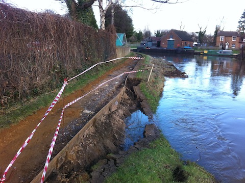
Part of the bank and towpath washed away by the flood near Dapdune Wharf. The path was closed today (December 28).
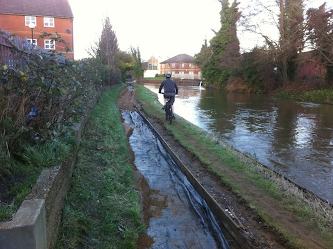
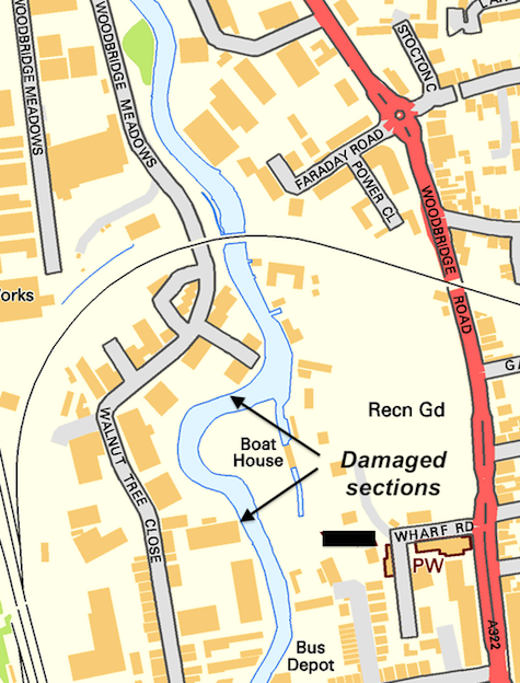
The towpath by the River Wey, in stretches opposite Dapdune Wharf and behind Walnut Tree Close, has been closed because it is unsafe.
The announcement came today in a comment sent to Guildford Dragon News after photographs of the damaged sections were published.
John Gibson, the navigations manager at the National Trust wrote: “The National Trust have now closed the towpath from Walnut Tree foot bridge to the railway bridge at Dapdune Wharf as a safety measure to protect towpath users.
…it may be several months before the towpath and bank can be repaired and reopened – navigation manager
“Your pictures clearly show the main area affected where the bank has been eroded greatly reducing the towpath width with a steep drop into deep water. There is a concern that the rest of the bank could give way while someone is walking or cycling along this stretch of the towpath with disastrous results for the individuals concerned.

Cost of the flood: The floodwaters washed away the towpath of the River Wey between the town and the seven arch bridge, Walnut Tree Close.
“Due to the depth of water at this location and the need to gain Land Drainage Consent from the Environment Agency for works within eight meters of a main river it may be several months before the towpath and bank can be repaired and reopened.
“The cost of repairs will also be substantial and the Trust, as a charity, would welcome any donations towards the cost of reinstating the bank and towpath through the centre of Guildford, a well used pedestrian and cycling route into the town centre avoiding the busy road network.
“The National Trust apologise for any inconvenience caused during this temporary closure of the towpath. Alternative routes along Walnut Tree Close or Bedford and Mary Roads are available.”
Responses to Flood Damage To Well Used Towpath Forces Closure
Leave a Comment Cancel replyPlease see our comments policy. All comments are moderated and may take time to appear. Full names, or at least initial and surname, must be given.
Recent Articles
- Burglar Jailed Thanks To Quick Action of Ash Resident
- Highways Bulletin for December
- Birdwatcher’s Diary No.318 Some Pre-Christmas Rambles
- Merry Christmas and a Happy New Year to All Our Contributors and Readers!
- More Units Added to Solums’s Station Redevelopment
- Vehicle Stop on Epsom Road Leads to Prolific Drug Gang Being Put Behind Bars
- Local Political Leaders Respond to Publication of the English Devolution White Paper
- Flashback: Guildford All Lit Up For Christmas – Then And Now
- City Earn Themselves a Three Point Christmas Present
- Mayor’s Diary: December 23 – January 4


Recent Comments
- Aubrey Leahy on Vehicle Stop on Epsom Road Leads to Prolific Drug Gang Being Put Behind Bars
- Sheila Newton on Memories of the Dennis Bros Christmas Party
- John Perkins on Two Unitary Authorities, One Elected Mayor – Most Likely Devolution Outcome for Surrey
- Gavin Morgan on Merry Christmas and a Happy New Year to All Our Contributors and Readers!
- David Roberts on Local Political Leaders Respond to Publication of the English Devolution White Paper
- Steve Grove on Merry Christmas and a Happy New Year to All Our Contributors and Readers!
Search in Site
Media Gallery
Dragon Interview: Local Artist Leaves Her Mark At One of England’s Most Historic Buildings
January 21, 2023 / No Comment / Read MoreDragon Interview: Lib Dem Planning Chair: ‘Current Policy Doesn’t Work for Local People’
January 19, 2023 / No Comment / Read MoreA3 Tunnel in Guildford ‘Necessary’ for New Homes, Says Guildford’s MP
January 10, 2023 / No Comment / Read More‘Madness’ for London Road Scheme to Go Ahead Against ‘Huge Opposition’, Says SCC Leader
January 6, 2023 / No Comment / Read MoreCouncillor’s Son Starts Campaign for More Consultation on North Street Plan
December 30, 2022 / No Comment / Read MoreCounty Council Climbs Down Over London Road Works – Further ‘Engagement’ Period Announced
December 14, 2022 / No Comment / Read MoreDragon Interview: GBC Reaction to the Government’s Expected Decision to Relax Housing Targets
December 7, 2022 / No Comment / Read MoreHow Can Our Town Centre Businesses Recover? Watch the Shop Front Debate
May 18, 2020 / No Comment / Read More


L Cairns
December 28, 2013 at 11:30 pm
Oh no. That’s my main safe cycle route to work every day. Not looking forward to delays. Hope it can be repaired soon as many people use the route daily into town.
John Gibson
December 30, 2013 at 5:27 pm
In response to L Cairns, yes I also cycle along the towpath to work and can appreciate the difficulty it causes when it is closed. We will try our best to repair the towpath as soon as possible, however the path and bank are badly damaged and I am afraid it will take time to put right.
John Gibson is the navigations manager at the National Trust
Jim Allen
December 31, 2013 at 4:00 pm
I too use this footpath on my way back from town and the soomer it is repaired the better.
Hopefully, when they ‘reinstate’ it they will cantilever the towpath footway over a widened river to allow more space for the water to escape the centre of town. An extra couple of square metres dimension along this section would provide an amazing release of the water levels experienced over the past week.