 Abraham Lincoln
If given the truth, the people can be depended upon to meet any national crisis...
 Guildford news...
for Guildford people, brought to you by Guildford reporters - Guildford's own news service
Where Is This? No.158
Published on: 30 Apr, 2015
Updated on: 30 Apr, 2015
By David Rose
The junction of Chertsey Street and North Street was the view seen in last week’s vintage photo, with a number of correct replies.
The coat of arms seen in the quirky picture can be found on the front of Abbot’s Hospital in the High Street. Well done to all those who replied and were correct and for the extra comments – particularly Chris Townsend.
Click here to see last week’s post and all the replies at the foot of it.
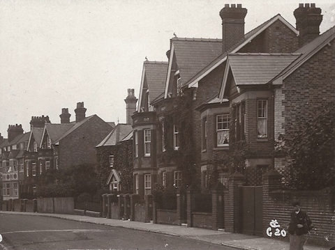
We move straight on to this next pair of images and the vintage one dates to about the 1910s and shows a residential road near the town centre. It’s from a picture postcard but I had to crop it on the left to remove the name of the road printed on the card. Not a lot has changed on the side of the road in view, but the other side (not in view) had large building put there is about 1962 and a replacement not so long ago. That should be a decent clue! Do you know which road this is then?
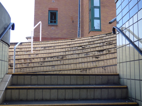
The quirky picture really is a bit like that this week – some steps at a strange angle. Yes they really are like that, not trick photography. Can you say where they can be found?
If you know the answers please leave a reply in the box below. All replies will be posted at about the same time next week, along with a new post with the answers to this week’s photos and the next pair of images.
Responses to Where Is This? No.158
Leave a Comment Cancel replyPlease see our comments policy. All comments are moderated and may take time to appear. Full names, or at least initial and surname, must be given.
Recent Articles
- Burglar Jailed Thanks To Quick Action of Ash Resident
- Highways Bulletin for December
- Birdwatcher’s Diary No.318 Some Pre-Christmas Rambles
- Merry Christmas and a Happy New Year to All Our Contributors and Readers!
- More Units Added to Solums’s Station Redevelopment
- Vehicle Stop on Epsom Road Leads to Prolific Drug Gang Being Put Behind Bars
- Local Political Leaders Respond to Publication of the English Devolution White Paper
- Flashback: Guildford All Lit Up For Christmas – Then And Now
- City Earn Themselves a Three Point Christmas Present
- Mayor’s Diary: December 23 – January 4


Recent Comments
- Aubrey Leahy on Vehicle Stop on Epsom Road Leads to Prolific Drug Gang Being Put Behind Bars
- Sheila Newton on Memories of the Dennis Bros Christmas Party
- John Perkins on Two Unitary Authorities, One Elected Mayor – Most Likely Devolution Outcome for Surrey
- Gavin Morgan on Merry Christmas and a Happy New Year to All Our Contributors and Readers!
- David Roberts on Local Political Leaders Respond to Publication of the English Devolution White Paper
- Steve Grove on Merry Christmas and a Happy New Year to All Our Contributors and Readers!
Search in Site
Media Gallery
Dragon Interview: Local Artist Leaves Her Mark At One of England’s Most Historic Buildings
January 21, 2023 / No Comment / Read MoreDragon Interview: Lib Dem Planning Chair: ‘Current Policy Doesn’t Work for Local People’
January 19, 2023 / No Comment / Read MoreA3 Tunnel in Guildford ‘Necessary’ for New Homes, Says Guildford’s MP
January 10, 2023 / No Comment / Read More‘Madness’ for London Road Scheme to Go Ahead Against ‘Huge Opposition’, Says SCC Leader
January 6, 2023 / No Comment / Read MoreCouncillor’s Son Starts Campaign for More Consultation on North Street Plan
December 30, 2022 / No Comment / Read MoreCounty Council Climbs Down Over London Road Works – Further ‘Engagement’ Period Announced
December 14, 2022 / No Comment / Read MoreDragon Interview: GBC Reaction to the Government’s Expected Decision to Relax Housing Targets
December 7, 2022 / No Comment / Read MoreHow Can Our Town Centre Businesses Recover? Watch the Shop Front Debate
May 18, 2020 / No Comment / Read More


Sue Warner
April 30, 2015 at 6:19 pm
The second picture – these are the steps from Wey House (Standard Life Building?) into the underpass on the Guildford one way system.
Bernard Parke
April 30, 2015 at 7:00 pm
1. The street which is now opposite G Live.
2. Steps at the underpass in Bridge Street.
Chris Townsend
May 2, 2015 at 11:46 am
The postcard view is of houses in Dene Road opposite the site of G Live.
The steps lead down from near the YMCA building on Bridge Street to the subway under the junction with Park Street and Farnham Road.
David Bennett
May 3, 2015 at 12:03 am
I believe the vintage photo to be of Dene Road, taken from the London Road end. The large buildings referred to would be the Civic Hall and more recent G Live.
The second photo is of the subway near the Farnham Road traffic lights.
Carol Norris
May 3, 2015 at 7:17 pm
Picture 1 : York Road
Picture 2 : possibly outside G Live
Doug and Bill Staniforth
May 5, 2015 at 2:19 pm
It’s Dene Road (we wondered what was on the site previous to the Civic Hall?).
The steps are in Bridge Street.
Word has it that G Live is presenting a stage show of “Bullseye the Musical on Ice”, can the Ed confirm?
This is amazing. How do you find the time to wonder about anything other than speedboats? Ed
Brian Holt
May 5, 2015 at 4:34 pm
1 I think it may be Dene Road taken from the junction of London Road, it’s behind the GLive building.
2 The underpass at the top of Bridge Street, going from the YMCA building to the railway station side.
Margaret Cole
May 6, 2015 at 7:35 am
The Victorian houses can be found in Dene Road facing G Live, off London Road, once grand family homes, but now mainly bedsits.
The quirky steps picture maybe the old underpass from High Street to Debenhams, but doubtful as you write like they are still there, perhaps trying to confuse us all.
Linda Jackson
May 6, 2015 at 1:44 pm
1. This looks like Dene Road, the Civic Hall was opposite which was replaced by G Live.
2. The underpass by the YMCA building.
Brian Holt
May 6, 2015 at 11:51 pm
The house The Firs in London Road, was where the Civic Hall was built, was our doctors’ surgery. T
here Was Dr Millligan (snr), Dr Hugo, and Dr Willis, they then moved to 2 West Road, and then to Merrow Park Surgery, Kingfisher Drive, Merrow.