 Abraham Lincoln
If given the truth, the people can be depended upon to meet any national crisis...
 Guildford news...
for Guildford people, brought to you by Guildford reporters - Guildford's own news service
Where Is This? No.220
Published on: 28 Jul, 2016
Updated on: 6 Aug, 2016
By David Rose
Plenty of excellent replies to last week’s mysteries…
Henley Fort on The Mount was seen in the vintage picture, while the wooden building in the quirky picture can be found in Shere. Now public loos, it was once the village’s fire station.
Click here to see last week’s post and all the replies at the foot of it.
Do have a look as both Chris Thomson and Dave Middleton provide a link to an amazing piece of film of the fire station shot in 1899! My friend and military historian Frank Phillipson also alerted me to this archive film.
There are also plenty of other details about Henley Fort and what it was used for – a mobilisation centre at the end of the 19th century when it was feared Britain might be invaded by the French, and during the Second World War when it became the HQ of the 4th (Guildford) Battalion Surrey Home Guard.
And some great comments from James Dix, whose re-enactment society represents the Queen’s Regiment and Surrey Rifles of the fort’s period. They’ll be there doing their drill displays this coming Heritage Open Days weekend. Well worth seeing.
While, the ‘jokes’ keep coming from the Stanniforth lads!
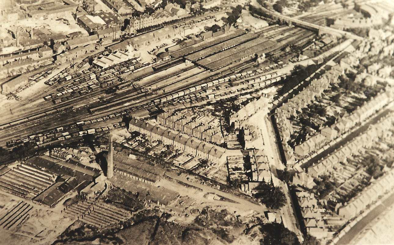
An aerial view this week for the vintage picture, that probably dates to the 1920s or perhaps 30s?
It shouldn’t be too difficult to work out where it is and what can be seen, but can you add some details?
Railway buffs may be able to give a better date.
What’s with the big chimney and the buildings that surround it?
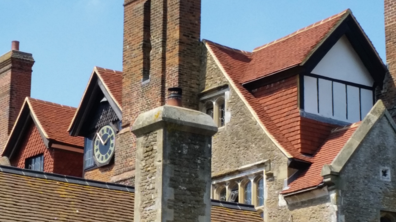
This week’s quirky picture was sent in by Jan Messinger. It features a part of a historic manor house just outside Guildford, but which one?
Note: some of the roof tiles are new. The stonework is the give-away feature.
Where Is This? is taking a well-earned break next week. If you know the answers to this week’s mysteries, please leave a reply in the box below – and include extra details if you have them. They will be published along with two more mystery images at about the same time the week after next. Good luck.
Responses to Where Is This? No.220
Leave a Comment Cancel reply
Please see our comments policy. All comments are moderated and may take time to appear. Full names, or at least initial and surname, must be given.
Click on cartoon for Dragon story: Public Asked for Views on SCC’s Proposal for Reduced Speed Limits


Recent Articles
- The Bishop’s Leap of Faith – From The Top Of The Cathedral
- Residents Urged to Have Their Say on the Changing Shape of Surrey’s Local Government
- Driver Given a Suspended Sentence After Head-on Collision With Motorcycle
- Birdwatcher’s Diary No.329
- Opinion: We Must Plan To Deal with Guildford Gridlock
- A281 Closure – Further Delay to Re-opening
- Centenary of Wood Street’s First Place of Worship, my Baptism Link with It and the Revd Deedes and his Family
- Care For Guildford Asks: Could You Be One Of Our Volunteers?
- Flashback: There Are Lessons To Learn from the Juneja Case – The Council Must Admit It
- GBC’s Plan For a Thriving Guildford ‘Is Our Promise to Residents’ Says Council Leader


Recent Comments
- Richard Benson on GBC’s Plan For a Thriving Guildford ‘Is Our Promise to Residents’ Says Council Leader
- Nigel Base on Letter: Recreational Rowing Might Be the Answer
- Anna Windebank on GBC’s Plan For a Thriving Guildford ‘Is Our Promise to Residents’ Says Council Leader
- Caroline Turnbull on Letter: Recreational Rowing Might Be the Answer
- Caroline Freeman on Letter: Recreational Rowing Might Be the Answer
- David Roberts on Letter: Recreational Rowing Might Be the Answer
Search in Site
Media Gallery
Dragon Interview: Local Artist Leaves Her Mark At One of England’s Most Historic Buildings
January 21, 2023 / No Comment / Read MoreDragon Interview: Lib Dem Planning Chair: ‘Current Policy Doesn’t Work for Local People’
January 19, 2023 / No Comment / Read MoreA3 Tunnel in Guildford ‘Necessary’ for New Homes, Says Guildford’s MP
January 10, 2023 / No Comment / Read More‘Madness’ for London Road Scheme to Go Ahead Against ‘Huge Opposition’, Says SCC Leader
January 6, 2023 / No Comment / Read MoreCouncillor’s Son Starts Campaign for More Consultation on North Street Plan
December 30, 2022 / No Comment / Read MoreCounty Council Climbs Down Over London Road Works – Further ‘Engagement’ Period Announced
December 14, 2022 / No Comment / Read MoreDragon Interview: GBC Reaction to the Government’s Expected Decision to Relax Housing Targets
December 7, 2022 / No Comment / Read MoreHow Can Our Town Centre Businesses Recover? Watch the Shop Front Debate
May 18, 2020 / No Comment / Read More


John Lomas
July 28, 2016 at 8:05 am
The tall chimney is at Guildford Park Brick Works, the smaller serried ranks to the left and below the chimney are probaby rows of stacked briscks waiting to be utilised in the 1920s to 30s Guildford expansion.
The two chimneys at the top left could well be the laundry between the river and the cattle market.
The section of Guildford Park Road leading straight up from the bottom of the picture is aiming straight at the coal loading stage the taller structure on the station site.
I think the quirky picture is Loseley Park.
Dave Middleton
July 28, 2016 at 11:25 am
Can’t place the manor house, but the aerial photo is of the railway station and marshalling yards, with the engine sheds in the top right-hand corner.
The building complex in the bottom right hand corner, with the large chimney is the Guildford Park Brick Works, where most of the bricks that were used to build Guildford Cathedral were made, from clay dug out of the lower part of Stag Hill, upon which the Cathedral sits.
Guildford Park Avenue now stands on the site of the brick works.
Bill and Doug Stanniforth
August 2, 2016 at 4:43 pm
The big chimney building was a brickworks used for the cathedral, or a secret factory making prizes for future quizzes (not very successfully as we’ve never seen one).
Loseley House possibly where Gilesy was a boot boy before he became a publishing magnate.
Yes, some of us move up and others just dream of speed boats! Ed
Chris Townsend
August 7, 2016 at 12:13 pm
The vintage picture is dominated by Guildford Park Brickworks (with chimney) and the railway station.
Guildford Park Road leads past the horse chestnut trees towards the railway bridge, with Rupert Road off to the left, and Ludlow Road and Denzil Road to the right.
The original Mission Church is visible with its small spire, by the trees at the entrance to the brickworks.
I don’t see the Passometer nor the detached house to its left, nor the Orphanage Hall, but there are extensive railway sidings, used by cattle trucks and goods wagons, but now long gone and mostly used for car parking, as is part of the brickworks site, at least for the time being.
Top right are the engine sheds arranged around the turntable. Walnut Tree Close and the river are across the top of the photo, and the houses of Bedford Road.
The quirky picture is of the south front of Loseley House, viewed from an unusual angle.
Bernard Parke
August 8, 2016 at 9:12 am
Brick field in which hand-made bricks were made for Guildford Cathedral.
There are examples of such bricks in France which are around a thousand years old.
Brian Holt
August 9, 2016 at 8:29 pm
Guildford railway station. There is no Platform 1 in the picture, which was built when the London Road line to Waterloo opened in the 1930s.
At the bottom of the picture is Guildford Park brickworks, with Rupert Road above it.
The clock is at the back of Loseley House, and can be seen from the gardens.
Margaret Cole
August 10, 2016 at 1:18 pm
The aerial view is of Guildford station with the Farnham Road bridge, and also Billings can be seen in Walnut Tree Close.
Now the second one a bit harder to find, but voila there it was, the south side of Loseley House in Littleton where the clock can be seen. It’s the private area so I was unable to drive around there. Fortunately my son Gary was up and he did some work there with his dad in the 1980s and knew it well.