 Abraham Lincoln
If given the truth, the people can be depended upon to meet any national crisis...
 Guildford news...
for Guildford people, brought to you by Guildford reporters - Guildford's own news service
Where is This? No.222
Published on: 17 Aug, 2016
Updated on: 17 Aug, 2016
By David Rose
In her comment to last week’s mysteries Margaret Cole wrote: “Not too difficult this week – for a change”.
Perhaps not, so thanks to all those who replied, most correctly identifying the vintage picture as the ferry crossing at St Catherine’s, with the quirky picture being a view looking across an open space that had been the site of the Friary Meux brewery, looking towards Onslow Street, and before today’s Friary centre was built.
I would guess the picture was taken in about 1974 or 1975 and the photographer was standing in Commercial Road. If I recall correctly, there were holes in the wooden fencing that surrounded the site and people could get a glimpse of the archaeologists at work on the site of the former Dominican Friary.
Thanks to all who replied and for the extra details and memories. Click here to see last week’s post for those replies.
Here this week’s pair of images – harder? Maybe!
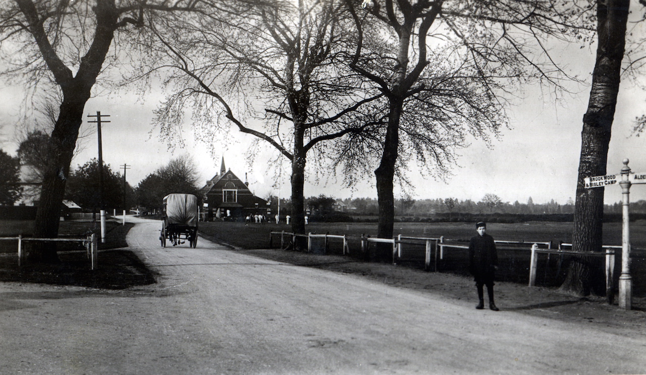
The vintage picture is an early 1900s postcard view of a village scene a few miles from Guildford.
Its village hall can been seen that is named after an interesting character who became a lord and took his title from the name of the village, but lived outside it.
The road sign on the right and what it states is the obvious giveaway.
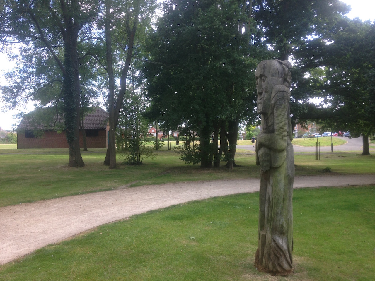
The quirky picture is of a wooden sculpture. The picture shows it in context with its immediate surroundings to perhaps make it easier to identify the location.
It can be found in a green space near a large modern housing development on the outskirts of Guildford. There is a playing field beyond the pavilion that was once used for the same purpose by the army. Hopefully enough clues then!
If you know the answers to this week’s mysteries, please leave a reply in the box below – and include extra details if you have them.
They will be published along with two more mystery images at about the same time next week. Good luck.
Responses to Where is This? No.222
Leave a Comment Cancel reply
Please see our comments policy. All comments are moderated and may take time to appear. Full names, or at least initial and surname, must be given.
Click on cartoon for Dragon story: Public Asked for Views on SCC’s Proposal for Reduced Speed Limits


Recent Articles
- Work to Repair Cottage on Closed A281 Underway
- Letter: Not All PIP Claimants Need It
- AI Technology at the Forefront of Surrey Conservation Project
- Mayor of Guildford Drops In on One of His Chosen Charities
- The Church’s Message Is As Relevant As Ever, Says Ash’s Retiring Priest
- CANCELLED: Have a Blooming Picnic – June 7
- Eight Out of Ten PIP Claimants in Guildford Face Cuts to Their “Lifeline”
- Waverley’s New Discretionary CIL Review Scheme To Be Revealed Soon
- Council Accepts Responsibility of Meeting Farnham Museum’s Ballooning Repair Costs
- Notice: Cut It Out!


Recent Comments
- Andrew Eacott on SCC Intends to Back Public Survey Result and Shorten Summer School Holidays
- Sally Astles on Stoke Park Was Bought 100 Years Ago with Plans for a Public Open Space and Houses!
- I Macpherson on Work to Repair Cottage on Closed A281 Underway
- Judith Simmons on A Look Back at Perry Hill’s New Inn and a Family That Once Ran It
- Bernard Quoroll on Community Councils Proposed to Maintain Local Representation
- John Lomas on A Look Back at Perry Hill’s New Inn and a Family That Once Ran It
Search in Site
Media Gallery
Dragon Interview: Local Artist Leaves Her Mark At One of England’s Most Historic Buildings
January 21, 2023 / No Comment / Read MoreDragon Interview: Lib Dem Planning Chair: ‘Current Policy Doesn’t Work for Local People’
January 19, 2023 / No Comment / Read MoreA3 Tunnel in Guildford ‘Necessary’ for New Homes, Says Guildford’s MP
January 10, 2023 / No Comment / Read More‘Madness’ for London Road Scheme to Go Ahead Against ‘Huge Opposition’, Says SCC Leader
January 6, 2023 / No Comment / Read MoreCouncillor’s Son Starts Campaign for More Consultation on North Street Plan
December 30, 2022 / No Comment / Read MoreCounty Council Climbs Down Over London Road Works – Further ‘Engagement’ Period Announced
December 14, 2022 / No Comment / Read MoreDragon Interview: GBC Reaction to the Government’s Expected Decision to Relax Housing Targets
December 7, 2022 / No Comment / Read MoreHow Can Our Town Centre Businesses Recover? Watch the Shop Front Debate
May 18, 2020 / No Comment / Read More


Sheila Hunt
August 17, 2016 at 11:34 pm
The village green at Pirbright.
Bernard Parke
August 18, 2016 at 9:16 am
Pirbright (and Lord Pirbright).
Also once the home of H.M.Stanley who is buried in the churchyard there.
John Lomas
August 18, 2016 at 10:15 am
The cricket team appear to be emerging from Lord Pirbright’s Hall on Pirbright Village Green.
The carved tree is just off what Google maps calls Kirke Fields, the photographer is looking towards Fairborne Way.
Mike Williams
August 18, 2016 at 3:38 pm
You kinda gave it away with the Lord Pirbright clue, and David, there’s a road sign thereabouts in French, what is the history of that please?
The sculpture looks familiar, a past Sy Ad editor maybe? – and is the location Queen Elizabeth Park?
[David Rose replies: I have not noticed the road sign in French. I will have a look and try to find out about it. Thanks.]
Chris Townsend
August 21, 2016 at 8:43 pm
The postcard view shows Pirbright village green, with Lord Pirbright’s Hall, beside what is now the A324. The hall is full of character, and not too much changed today from this view of 1908:
http://www.francisfrith.com/pirbright/pirbright-town-hall-1908_59668
From http://www.parish-council.com/Pirbright/index.asp?pageid=16350
“Lord Pirbright built the Hall in 1899, when it was opened by Princess Christian, and he donated it to the Parish in 1901 to commemorate the accession of King Edward VII.”
More info’ about Lord Pirbright, who lived at Henley Park, here: http://normandyhistorians.co.uk/aandp18.html
I’m not sure about the quirky sculpture. I’ll guess it’s near the playing field that once belonged to Stoughton Barracks, between Harts Gardens and Fairborne Way.
Steve Pownall
August 22, 2016 at 10:04 pm
Pirbright is the easy bit – but who top scored in the cricket match that followed?