 Abraham Lincoln
If given the truth, the people can be depended upon to meet any national crisis...
 Guildford news...
for Guildford people, brought to you by Guildford reporters - Guildford's own news service
Where Is This? No.3
Published on: 6 Apr, 2012
Updated on: 8 Apr, 2012
by David Rose
Readers’ replies to last week’s mystery photos have now been added to the original story. Click here to see. Carl Norris, Bernard Parke, Irene Shettle and Ian Plowman have, between them, spotted the locations.
The first picture was of the junction of Old Palace Road and The Chase. See Ian’s interesting comments about the area and the shops once there.
The second picture appeared to be harder to identify. It shows Ladymead in about the 1980s before today’s retail park was built. I was a bit crafty in cropping the original picture. Off to the left is Woodbridge Road. So, if you stood at the same spot today you would roughly be looking towards Burger King with Homebase away beond the car park. Just out of view in the old photo is the Bridge Cafe. Who remembers that?
On to this week’s two images. The one above is cropped from an aerial view of Guildford. I think it dates from the late 1960s. Can you name any features seen in it?
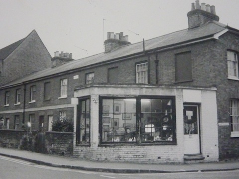
The picture (below) features a row of cottages and what appears to be an antiques shop. Do you know where it is? And, does anyone have any ideas as to why some of the windows have been bricked up? I am not sure of the date these houses were built, but the Window Tax that existed in Britain from the late 17th century, was repealed in 1851.
If you think you know all, or some of the answers, leave a reply in the box below. All replies will be posted at the same time in about a week’s time, along with a new post with the answers to this week’s photos, and the next pair of images.
Responses to Where Is This? No.3
Recent Articles
- Pedestrian Seriously Injured On Farnham Bypass – Police Appeal For Witnesses
- New Housing Planned To Replace Stables On Edge Of Wood Street Village
- Debt Charity’s New Report on State of Poverty in the South East and Help Available for People
- Local Government Reorganisation ‘A Great Opportunity To Start from Scratch’
- Notice: Poetry Competition – Enter by November 8
- Community Survey Planned To Discuss Future of the Troubled Electric Theatre
- 2025 Services of Remembrance to Honour our War Dead
- No Promise of A Mayor for Surrey
- Letter: This Decision Is an Outrageous Stitch-up
- The Spooky Hotel That Inspired The Winning Entry In Our Short Story Competition


Recent Comments
- RWL Davies on No Promise of A Mayor for Surrey
- John S Green on ‘Disaster in the Making’: Residents React with Anger and Distrust
- Amari Hawthorne-Bailey on Memories Of Queen Elizabeth Barracks And The Women’s Royal Army Corps
- Patrick Bray on It’s Two Unitaries for Surrey – SoS Says It Is Best Option for Financial Sustainability
- Mary English on Electric Theatre In Crisis As Financial Pressures Hit – Annual Loss of Over £250k
- Jackie Montague on Dragon Review: 2:22 A Ghost Story – Yvonne Arnaud Theatre
Search in Site
Media Gallery
Cllr Townsend on Waverley’s CIL Issue
August 27, 2025 / Comments Off on Cllr Townsend on Waverley’s CIL Issue / Read MoreMP Zöe Franklin Reviews Topical Issues
August 27, 2025 / Comments Off on MP Zöe Franklin Reviews Topical Issues / Read MoreMP Hopes Thames Water Fine Will Be ‘Final Nail in Its Coffin’
August 27, 2025 / Comments Off on MP Hopes Thames Water Fine Will Be ‘Final Nail in Its Coffin’ / Read MoreNew Guildford Mayor Howard Smith
August 27, 2025 / Comments Off on New Guildford Mayor Howard Smith / Read MoreA New Scene for a Guildford Street
August 27, 2025 / Comments Off on A New Scene for a Guildford Street / Read MoreDragon Interview: Sir Jeremy Hunt MP on His Knighthood and Some Local Issues
August 27, 2025 / Comments Off on Dragon Interview: Sir Jeremy Hunt MP on His Knighthood and Some Local Issues / Read MoreDragon Interview: Paul Follows Admits He Should Not Have Used the Word ‘Skewed’
August 27, 2025 / Comments Off on Dragon Interview: Paul Follows Admits He Should Not Have Used the Word ‘Skewed’ / Read MoreDragon Interview: Will Forster MP On His Recent Visit to Ukraine
August 27, 2025 / No Comment / Read MoreDragon Interview: Fiona Davidson on the ‘Devolution’ Proposals for Surrey
August 27, 2025 / No Comment / Read More


Bernard Parke
April 7, 2012 at 6:22 am
1) View looking down to walnut tree close and the Sports Ground,
2) shop on the corner of Stoke Road and Martyr Road
David & Ann Bailey
April 7, 2012 at 12:04 pm
1st Picture The cricket ground in Woodbrige Rd,you can see the Methodist Church on the corner of Woodbride Rd and Wharf Rd ,the doctors surgery in Wharf Rd,St Savious vicarige and the Railway
2nd pic is on the corner of Martyr Rd and Chertsey Street and was an Antique Shop
Valerie Bale
April 7, 2012 at 5:05 pm
I think the pale grey area in the middle distance is the county cricket ground. Maybe the photo was taken from Stag Hill looking down over Walnut Tree Close?
Ian Plowman
April 12, 2012 at 6:26 pm
The aerial picture is taken from above where the university is now built. Woodbridge Road Cricket Ground is the main feature in the picture. Just off the the right of the picture would be Yorkies Bridge across the railway
Picture 2 has me stumped
Regards
Ian
Angela Gunning
April 14, 2012 at 8:07 pm
Looks like the corner of Stoke Road and Martyr Road, the shop long since demolished.
Bernard Parke
April 15, 2012 at 5:44 pm
We used to refer to such shops during that period of time as “second hand shops”. The name antique found favour at a later time.
The shop later became a men’s hairdressers.
Simon Vine
April 30, 2012 at 9:21 pm
Relating to Bridge Cafe, I remember it well. Run by a nice gent called Pat who used to sell his wares in Plastic Coatings factory when I was working there as a student in summer 1977