 Abraham Lincoln
If given the truth, the people can be depended upon to meet any national crisis...
 Guildford news...
for Guildford people, brought to you by Guildford reporters - Guildford's own news service
Residents Meet Over Fears For Cathedral Hill Homes Plan
Published on: 25 Jan, 2016
Updated on: 25 Jan, 2016
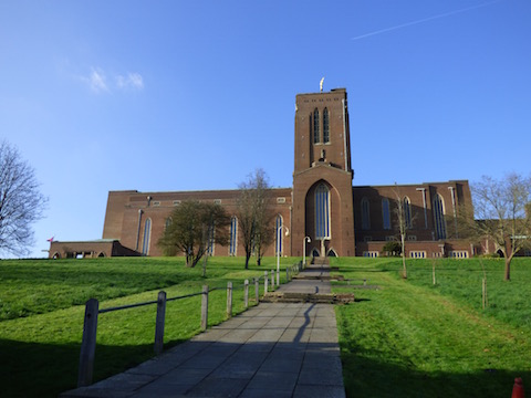
More than 60 people attended a meeting to hear about plans to build homes on the eastern and southern slopes of Stag Hill beside Guildford Cathedral.
Linden Homes’ planning application is for 134 properties on the site, owned by Guildford Cathedral, which protesters cite as a protected green space, as designated in Guildford’s 2003 Local Plan.
It is believed that Guildford Cathedral hopes to generate £15 million from the endowment it would receive to help preserve and maintain the building.
A spokesman for the meeting that took place on Thursday, January 21, at Guildford Park Church, said: “Plans of the development were on display and were noted by many attendees to be very different from the publicity picture commonly used by Linden Homes and the cathedral.
“The publicity picture shows green space and low-rise properties whereas the reality is very different and includes 15m high blocks of flats.”
Fears expressed were over the high density of homes in the plan and limited affordable housing, the inevitable increase in the volume of traffic, and the lack of parking spaces provided in the development would lead to issues for the surrounding streets.
Other concerns voiced included the impact on the local infrastructure, such as schools, flooding and subsidence.
Those attending heard the claim that Guildford Cathedral has not always had a desire to strengthen its ties with the general public.
Mention was made of the closure of a public footpath in 2001 on land to the east of the cathedral, which led to the loss of public access to the east field, was encouraged by the cathedral; Number 4 Cathedral Close was built across part of this footpath.
During that application for closure of the footpath it was suggested that the footpath be re-routed so that public access could continue, but the cathedral objected.
The spokesman added: “They did not at that time seem to want the contact with the outside community which now forms part of their stated reasons for supporting the construction of a housing estate. This loss of public access to the east field gives precedent to the cathedral’s continuing disregard for protected environments. The new plans also propose to develop roads through protected hedgerows and trees, an environment that existed long before the cathedral.
Fears were also expressed that Guildford Borough Council’s planners may view the proposal in isolation, which would therefore not take into account the further impact that other proposed developments, such as those at Blackwell Farm, Guildford Park car park and Guildford railway station, will have on the local area, local traffic and the community.
The meeting was also attended by the three councillors from the Onslow ward in which the proposed development falls. The councillors were provided information on the procedures and context of the application.
The Stag Hill Community Group, a small working party, to move matters on from the meeting has now been formed. It is an interest group formed by residents of Arlesford Road, Ridgemount and Scholars Walk. The group wishes to protect the open spaces, hedgerows and visual appearance of Stag Hill, all aspects it says the cathedral wishes to destroy.
Responses to Residents Meet Over Fears For Cathedral Hill Homes Plan
Leave a Comment Cancel reply
Please see our comments policy. All comments are moderated and may take time to appear. Full names, or at least initial and surname, must be given.
Click on cartoon for Dragon story: Public Asked for Views on SCC’s Proposal for Reduced Speed Limits


Recent Articles
- Motorcyclist Arrested After Police Chase
- Notice: GTA German Filmfest – July 2
- Letter: We Need More Yellow Boxes and Enforcement
- Notice: What’s On in July at Guildford Cathedral
- Greenfield, Greenbelt Site Deemed ‘Greybelt’ by Planning Inspector
- Letter: WBC’s CIL Recommendations Are Too Little, Too Late
- Letter: Yellow Box Fines Are Just a Money-raising Opportunity for SCC
- Drivers Caught in Yellow Box Junctions at the Dennis Roundabout Paid £81k to SCC
- Residents Hit By CIL Fees Should Be Offered Full Review, Says Overview Committee
- Plans For New Guildford Preschool Rejected On Road Safety Grounds


Recent Comments
- David Roberts on New Electric Trains Now Arriving at Guildford – 100 Years After the First One Did
- Mark Stamp on Greenfield, Greenbelt Site Deemed ‘Greybelt’ by Planning Inspector
- Simon Dickinson on Drivers Caught in Yellow Box Junctions at the Dennis Roundabout Paid £81k to SCC
- Paula Smith on Comment: What Are We To Make of the GBC Executive ‘Reshuffle’?
- Jim Allen on Drivers Caught in Yellow Box Junctions at the Dennis Roundabout Paid £81k to SCC
- Wayne Smith on Plans For New Guildford Preschool Rejected On Road Safety Grounds
Search in Site
Media Gallery
Dragon Interview: Local Artist Leaves Her Mark At One of England’s Most Historic Buildings
January 21, 2023 / No Comment / Read MoreDragon Interview: Lib Dem Planning Chair: ‘Current Policy Doesn’t Work for Local People’
January 19, 2023 / No Comment / Read MoreA3 Tunnel in Guildford ‘Necessary’ for New Homes, Says Guildford’s MP
January 10, 2023 / No Comment / Read More‘Madness’ for London Road Scheme to Go Ahead Against ‘Huge Opposition’, Says SCC Leader
January 6, 2023 / No Comment / Read MoreCouncillor’s Son Starts Campaign for More Consultation on North Street Plan
December 30, 2022 / No Comment / Read MoreCounty Council Climbs Down Over London Road Works – Further ‘Engagement’ Period Announced
December 14, 2022 / No Comment / Read MoreDragon Interview: GBC Reaction to the Government’s Expected Decision to Relax Housing Targets
December 7, 2022 / No Comment / Read MoreHow Can Our Town Centre Businesses Recover? Watch the Shop Front Debate
May 18, 2020 / No Comment / Read More


DAVID SMITH
January 26, 2016 at 12:45 pm
Without commenting on the merits or drawbacks of any scheme you have to ask where do people want us to build?
So far we have seen proposals for Gosden Hill in Burpham, Blackwell Farm, Wisley, cathedral grounds and Guildford raileay station.
Every single scheme is being fiercely opposed by residents and you start to wonder if the general consensus amongst some people in the town is to never build anything anywhere.
In relation to the cathedral site, having attended the University of Surrey I always used to walk up through the grounds down the main steps to the Ridgemount.
The grounds always seemed vast, uninteresting and exposed.
I don’t recall ever seeing anyone walk there, making it feel very unwelcome.
Building on a portion of this land would surely make it feel less barren.
Ngaire Wadman
January 26, 2016 at 12:53 pm
What about the very real likelihood that the open land on Stag Hill was purchased and dedicated as a war memorial, to the Canadian soldiers of both world wars?
Is it legal to build on war memorial land?
Quite apart from the vast amounts of very noisy, expensive pile-driving that will be needed to get down to solid ground, this to me seems a sickening betrayal of the enormous generosity of Viscount Bennett.
There is little enough easily accessible open land in and around Guildford as it is – the steep hilltops are pretty, but very difficult for access – desecrating a war memorial ground seems a terrible thing to do.
Bernard Parke
January 26, 2016 at 3:58 pm
I read with some interest the comment made above about some people in the town never wanting to build anywhere.
This is a little unfair.
In my banking days, when any building project was proposed, we always insisted that the roads system etc was always completed before any building was even started.
In Guildford we must follow this dogma, however unpopular, if we are not to be subject to complete gridlock.
David Smith
January 26, 2016 at 8:47 pm
In reply to Bernard Parke’s comment:
That may be true, but the station flats do not have parking and cars will not be permitted.
Wisley is right next to the A3 etc, Boxgrove Gardens was 200 homes by Linden and has had a negligible impact on road infrastructure.
C Stevens
January 27, 2016 at 4:09 pm
In reply to David Smith,
Solum’s revised planning summary (on the GBC website dated 13 November 2015 under Planning Document) says that there will be 644 spaces in the new multi-storey car park with an additional 69 residential spaces at ground floor level.
Of this total number 230 will be residential spaces, ie 0.54 spaces per unit.
Terry Stevenson
January 27, 2016 at 12:03 am
And then there’s the opposition (on these pages) to the non-residential developments:
Waitrose – no
Aldi – no
Clay Lane link road – no
to name but a few recent examples.
Jim Allen
January 27, 2016 at 12:03 am
I quite agree with Bernard.
First we must understand where the traffic comes from and goes to, then we must think logically using ‘what if’ to assess the various options then and only then decided if we need new roads or simply follow the observations in the Institute of Economic Affairs document which can be found at
http://www.iea.org.uk/in-the-media/press-release/rip-out-80-of-traffic-lights-to-boost-economy-road-safety
And simply remove the ‘blockages’ of traffic light timings and unused bus lanes.
Sara Tokunaga
February 3, 2016 at 1:16 am
In response to Mr Smith stating he never encountered anyone on his walk from the university down the steps to Ridgemount, he must have been walking at very unusual times!
I walk my dog there frequently and have done for a number of years. I first met some of my best friends there, also walking their dogs.
The scale of the development is excessive, and cannot be absorbed into the surrounding areas.
This is not a NIMBY attitude, but a practical one.
The problem of excess drainage water has not been addressed, neither has the traffic situation.
Add that to the extra strain on local schools and local doctors’ surgeries.
The area is frequently gridlocked and getting an appointment with the local doctor is increasingly difficult. The local schools are massively oversubscribed already.
Cut down the size of the development, improve the road system, drainage, schools and local health services. Then this might be a planning application that could be considered.