- Stay Connected

Socialize

 Abraham Lincoln
If given the truth, the people can be depended upon to meet any national crisis...
Abraham Lincoln
If given the truth, the people can be depended upon to meet any national crisis...

 Guildford news...
for Guildford people, brought to you by Guildford reporters - Guildford's own news service
Guildford news...
for Guildford people, brought to you by Guildford reporters - Guildford's own news service
A Thousand Homes For Slyfield – But Where Will Council Depot And Sewage Works Be Relocated?
Published on: 30 Mar, 2015
Updated on: 8 Jan, 2016
The regeneration of Slyfield, to include 1,000 homes, has moved a step nearer following the announcement of government support and low-cost borrowing available to the borough council.
Now, Guildford Borough Council will release £390,000 of funding to get the scheme going.
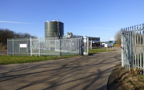
Thames Water’s sewage treatment works at Slyfield will be relocated before the 1,000m homes can be built.
The Slyfield Area Regeneration Project (SARP) has been designated as a housing zone by the Government’s Homes & Communities Agency (HCA).
GBC’s lead councillor for transport, infrastructure and the environment, Matt Furniss, said:“We are delighted that the site has been designated as a housing zone. SARP is a major urban regeneration scheme that can deliver 1,000 homes, including affordable homes, on a brownfield site and make a significant contribution to Guildford’s growing housing need.”
Land near the sewage works, some of it is where Guildford’s rubbish was dumped in years gone by.
The project will not be an easy one. For the homes to be built, it will require the relocation of the council depot off Stoke Road, and also the relocation of Thames Water’s sewage treatment works that is further east, close to Stoke Lock and the River Wey Navigation. The plan also includes provision for two industrial units and a new Surrey County Council waste treatment plant.
The council hopes to see this work begin within the next three or four years. An indication of what will be going where has been made on a SARP indicative layout site plan prepared by architects Scott Brownrigg for Guildford Borough Council, available to view on the council’s website.
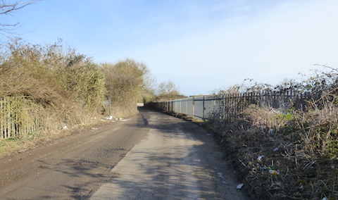
Looking back along the lane from the sewage works towards the recycling depot at the end of Moorfield Road.
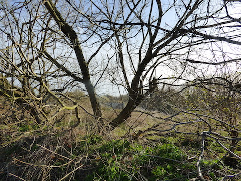
There is council-owned land between the river and the Slyfield recycling centre at the end of Moorfield Road. Much of this is ‘waste land’, and some of it contains the town’s rubbish that was dumped there from the end of the 19th century until the ‘dust destructor’ (now commonly called a waste incinerator) was built in 1910. That is where the council depot is today. Landfill of rubbish was then started again in the years after the Second World War and some of this land is now built on and is part of the Slyfield Industrial Estate. An area of land, towards the fields of Burpham Court Farm in Clay Lane, is also landfill that has not yet been built on.
Mr Furniss added that the designation of the site as a zone for affordable housing “means that access to cheaper borrowing has been unlocked.”
The Secretary of State for Communities and Local Government, Eric Pickles, said: “This extra Government funding and support will help Guildford Borough Council kick-start the regeneration of the Slyfield site, providing new homes on brownfield land. This will help the council protect the green belt and play its part in meeting Guildford’s growing housing needs.”
The council’s upfront funding of £390,000, that was agreed at its latest Executive meeting, will pay for consultants to advise on the initial preparatory works required and how it will progress. The Executive also agreed to enter into a memorandum of understanding with Thames Water to assist in the partnership working that will be required.
Share This Post


Responses to A Thousand Homes For Slyfield – But Where Will Council Depot And Sewage Works Be Relocated?
Leave a Comment Please see our comments policy. All comments are moderated and may take time to appear. Full names, or at least initial and surname, must be given.

I'm living well for nothing at all! (See: No Trifling Matter: Magpie Trapped in Godalming Sainsbury’s)


Next stop, Debt Chasm! (See: We Should All Be Outraged About the Failure to Deal with Legacy Debt)


Jim Allen
March 30, 2015 at 11:33 pm
Shame they are damming the zone 3b flood plain situated in the green belt. The link road will make Jacobs Well a giant roundabout.
This plan should not be going forward without the democratic process of the local plan.
John Robson
April 1, 2015 at 8:28 am
Halelujah……
Yes, it’s a bit more problematical, but this is the type of development that Guildford should be prioritising.
Well done GBC.
Jim Allen
April 1, 2015 at 1:44 pm
I guess Mr Robson doen’t live in Burpham or Merrow, where the sewers will be flooded by the link road for this project, or in one of the 14 homes threatened with flooding. Nor be affected by the HGVs thundering down the C road (Clay Lane) into the enlarged Slyfield Industrial Estate through residential areas of Burpham. Thus increasing potential accident rates by 500% (putting HGVs on C class roads does this nationally) and endangering our school children in our recently enlarged primary school.
There is a policy to keep HGVs off side roads. This project aims to move vehicles on to this C road to the detriment of the existing community.
One must also consider the wisdom of moving the most important piece of infrastructure in the community. That is to locate the ‘sweet spot’ for its purpose (down from town above the flood plain) which serves the whole community, when there are other sites available for development lying unused and recently cleared.
Brownfield is a term used in urban planning to describe land previously used for commercial uses or industrial purposes. Such land has been contaminated with hazardous waste or pollution or is feared to be so.
The current water works site is in use, thereby fails this description.
With certain legal exclusions and additions, the term brownfield site means real property, the expansion, redevelopment, or reuse of which may be complicated by the presence or potential presence of a hazardous substance, pollutant, or contaminant. Who would want to live on such a site?
The more I see of this poorly thought-out vanity proposal I bet there will be no low-cost housing adjacent the river side, only high priced ‘bragging rights housing’.
I seriously question the wisdom of the proposal on any level save political rhetoric.
John Lomas
April 1, 2015 at 7:52 pm
How much fill will be needed to lift the land 10ft or even more to make it unlikely to flood and how badly will that affect properties further downstream?
Peta Malthouse
April 2, 2015 at 1:53 pm
I welcome this news. The proposal for using the land for housing goes back very many years and could only move forward with the co-operation of Thames Water and Surrey County Council.
Well done for achieving that co-operation.
A significant sum of money has been promised by the Government to address the infrastructure problems referred to in the area already. But none for the rest of the borough where huge development areas proposed over flood plains served by insufficient drainage and overloaded roads are identified.
The big problem for Guildford is the determination of the Tory-led borough council to expand the town exponentially.
For me, the only way is up and on brownfield sites which already have the benefit of good road and rail links. Now, where can we find those?
jim Allen
April 2, 2015 at 2:16 pm
This is an extract of correspondence from the promotional team of this project, I received today.
I note the proposed roundabout bisects and dams the flood plain and sits in the middle of the deepest part of the flood plain. No business need has been demonstrated and industrial buildings and sites lie unused throughout Guildford.
“The agencies have stated that they will object to a road which bisects the flood plain and open landscape and crosses River Wey as there will be potential for significant environmental impact. The proposed route option has been chosen taking into consideration these views and to fulfil the needs of the businesses on the industrial estate.” How?
“The council has been advised by the Environment Agency not to build on the flood plain.”
One wonders if we are speaking the same language and using the same dictionary.
Ngaire Wadman
April 7, 2015 at 3:06 pm
On a possibly frivolous note, that’ll be the ultimate in ‘brown’ field sites. Just imagine the tomatoes that will grow there! Or will it be sealed with many feet of concrete and rubble?
So the sewage works will be rebuilt on greenfield land, further east – what environmental impact will that have?
Pete Knight
April 9, 2015 at 9:30 am
In response to Jim Allen.
I think his views are completely biased, bearing in mind where he live. Has he heard of the term Nimby?
These proposals make a lot of sense, the vehicles on Burpham’s roads may increase slightly but overall the plans will take a hell of a lot of vehicles off other residential roads in the Stoke ward and, in the majority of cases, divert vehicles from both locations.
Burpham is not the epicentre of Guildford. Why should other areas of the town (e.g. Stoke Ward) bear all of Guildford’s traffic alone and let places like Burpham provide or contribute no infrastructure yet benefit from the positive economic growth and activity that Slyfield brings?
Jim Allen
January 9, 2016 at 12:00 am
In reply to Pete Knight:
Nimby was first used ‘against’ me as a derogatory insult by a consortium development’s barrister at the Foxley Wood planning hearing in the 1980s. He apologised almost immediately when I pointed out a few pertinent facts. So I’d appreciate you consider in future your use of this insulting term and check out the facts below.
Burpham is not the epicentre of Guildford but is the gateway to and from the of north Guildford, the A3 – thus is special for this reason alone (apart from being the first neighbourhood plan to go to referendum (February 18, 2016) Incidentally, have you started yours yet?
It was for this specific reason 800-plus signatures were laid before the borough council (from Jacobs Well and Burpham) to delay a decision on the road until Highways England had displayed their plans for the A3. But we wouldn’t want that to cloud judgement would we? That would be a rational step too far for all misled supporters of this ‘flood plain road’.
As no one knows where the vehicles come from and go to when using Slyfield business park, it is a very rash assumption to make a claim that the Stoke area will improve, if as you assume you move a hell of a lot of traffic to where it very likely doesn’t want to be – stationary on Clay Lane.
GBC accept there is already more daily traffic on Clay lane than the A320 at Slyfield. Where is the logic in making it worse? Moving traffic on to other roads does not cure the base problem, rational road layouts do.
This road will assist no one in the traffic problems of Guildford.
My home location makes no difference to this rational approach. I look at this project on a harsh rational basis of facts and figures, not deviated by unsubstantiated assumptions and publicity material which includes misleading and inaccurate statements.
If it is biased to point out these factual anomalies, then it is very clearly biased in favour of the technical and rational truth. Is there something wrong with that?
Patrick Ayling
January 8, 2016 at 4:54 pm
I would like to know, what will happen to the allotments on the other side of sewage works?
[Ed: We have now added an extra image to the story that shows what the development may look like. I appears that houses will be built on the allotments.]
Jim Allen
January 9, 2016 at 12:07 am
In reply to Patrick Ayling:
Somehow an exit will have to be made on to the A320 at Bellfields roundabout, which could mean thousands of cars using Bellfields Road or Mangles Road to gain straight access to the site.
But this has not been displayed yet! So who knows what they have planned?