 Abraham Lincoln
If given the truth, the people can be depended upon to meet any national crisis...
 Guildford news...
for Guildford people, brought to you by Guildford reporters - Guildford's own news service
Letter: Council Should Use Computer Modelling When Deciding Harm of Planning Applications
Published on: 13 Jan, 2025
Updated on: 13 Jan, 2025
chair of the Guildford Society
John Harrison in his Opinion Piece “Why Are Five-storey Blocks Allowed in An Area of Outstanding Natural Beauty?“, summarises the reasons why St Catherine’s Village Association and the Guildford Society both spoke at the recent Planning Committee objecting to the scheme.
To reinforce two of Mr Harrison’s points…
Verified Views
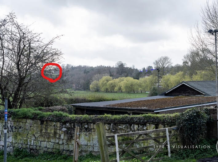
The use of Verified Views is problematic, as they are dependent on proper selection of viewpoints. As an example the Law College Site had a view showing the impact of the proposed development from beside the Rowing Club.

The predicted view of St Catherine’s Chapel (circled) from the pathway by Guildford Rowing Club, as shown to GBC’s Planning Committee when they were deciding the planning application for the College of Law. Cropped for width and annotated by GSoc.
Outlined in Red is the Grade I St Catherine’s Chapel – hidden behind a tree! Walking down the pathway towards Shalford or across the meadows to the footbridge across the Wey, opens up the view of the Chapel. No views have been provided to consider the impact of the development as pedestrians and cyclists travel south of the Rowing Club.
The Society strongly supports John Harrison’s comments on the use of available computer modelling to compliment “verified views”.
Car Park
John Harrison mentions the developer has left the proposed Stage 3 part of the development undeveloped as the present surface car park. The surface car park is covered by Policy A34 in the Local Plan to provide 112 units of student housing. Policy A34 comments that any development has as a Requirement (1) Significant regard to height of buildings with specific regard to the setting of the Grade II listed Braboeuf Manor.
The now-consented scheme, due to its mass and scale, certainly breaks this requirement for parts of the site that are far closer than the car park.
A concern is that the car park would, if developed to comply with Policy A34 would have been a building of 2-3 storeys. The existence of far larger blocks now consented will set a precedent for development on Stage 3 of the site along the lines proposed in the original application.
Protecting our landscape
The consent of this application highlights the increasing pressure on the Surrey Hills National Landscape by development on its borders, such as the Law College site. There will also be demands to build within its borders to meet the Government target of 1.5 million homes.
It raises the question as to whether the Surrey Hills National Landscape should be upgraded to be a National Park. National Parks, although having similar powers in relation to land adjoining their borders, do appear to carry more “weight” in planning applications. National Parks, as they act as a Planning Authority, also have more planning resource to examine and comment on planning applications.
Recent Articles
- Ash Residents To Hear Plans For New Care Home On Land Set Aside For Health Purposes
- Police Seek Witnesses After Vintage Sign Is Stolen From Pub Garden
- ‘Help Us To Track Wildlife This Autumn’ – Surrey Charity’s Plea To Nature Lovers
- Letter: Are Vendor-linked Awards the Way to Go for Schools’ ICT?
- Letter: How Not to Engage the Public
- GBC Takes Legal Action Over Unauthorised Bramley Traveller Site
- Developers Release Early Plans For 950 Homes on Normandy Farmland
- Open Day at Silverbirch House Care Home and a Special Gift for One of its Residents
- Birdwatcher’s Diary No.336
- Behind The Picture Of Wealth and Prosperity – Surrey Has a Story of Inequality and Poverty


Search in Site
Media Gallery
Cllr Townsend on Waverley’s CIL Issue
August 27, 2025 / Comments Off on Cllr Townsend on Waverley’s CIL Issue / Read MoreMP Zöe Franklin Reviews Topical Issues
August 27, 2025 / Comments Off on MP Zöe Franklin Reviews Topical Issues / Read MoreMP Hopes Thames Water Fine Will Be ‘Final Nail in Its Coffin’
August 27, 2025 / Comments Off on MP Hopes Thames Water Fine Will Be ‘Final Nail in Its Coffin’ / Read MoreNew Guildford Mayor Howard Smith
August 27, 2025 / Comments Off on New Guildford Mayor Howard Smith / Read MoreA New Scene for a Guildford Street
August 27, 2025 / Comments Off on A New Scene for a Guildford Street / Read MoreDragon Interview: Sir Jeremy Hunt MP on His Knighthood and Some Local Issues
August 27, 2025 / Comments Off on Dragon Interview: Sir Jeremy Hunt MP on His Knighthood and Some Local Issues / Read MoreDragon Interview: Paul Follows Admits He Should Not Have Used the Word ‘Skewed’
August 27, 2025 / Comments Off on Dragon Interview: Paul Follows Admits He Should Not Have Used the Word ‘Skewed’ / Read MoreDragon Interview: Will Forster MP On His Recent Visit to Ukraine
August 27, 2025 / No Comment / Read MoreDragon Interview: Fiona Davidson on the ‘Devolution’ Proposals for Surrey
August 27, 2025 / No Comment / Read More


Recent Comments