 Abraham Lincoln
If given the truth, the people can be depended upon to meet any national crisis...
 Guildford news...
for Guildford people, brought to you by Guildford reporters - Guildford's own news service
Where Is This? No.211
Published on: 25 May, 2016
Updated on: 25 May, 2016
By David Rose
Several readers correctly identified last week’s mystery vintage picture as being the former North Place Day Centre, now the car park of the Waitrose store.
Click here to see all the replies at the foot of last week’s post.
I like Margaret Cole’s replies each week as she often comments whether the images were easy or difficult to identify!
Last week’s quirky picture of two telephones boxes can be found in Tunsgate near Tunsgate Arch.
Before we move on to this week’s mysteries, Frank Phillipson has been doing some research regarding the picture of 1948 London Olympic Torch runners featured in Where Is This? No.208 with a number of replies in 209.
He writes: “When I saw the photo of the Olympic Torch carrier it didn’t seem like it could be Woodbridge Road. However, I’ve gradually started to see that it possibly could be that location but from a angle I hadn’t considered looking at before.”
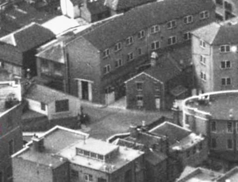
Still not totally convinced, Frank had a look at the Britain from Above website and has emailed this image from it that he believes correctly identifies the location. And I agree. I am sure I have seen that white gate before in another photo I have somewhere.
My copy of Kelly’s Directory of Guildford, Godalming and Neighbourhood, for 1950 lists the properties seen in the photo. With North Street away to the left, I think the curved building could be Home Counties Dairies. This was the milk delivery arm of Cow & Gate. The building to the far right was, I think, also Cow & Gate premises. Is the building with the ‘white ring’ around the roof top Post Office Telephone’s Bell House in Lea Pale Lane?
Here are this week’s pair of images…
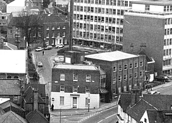
Staying with ‘views from above’ here is a cropped view of part of Guildford town centre pictured in the 1980s. The office building seen top right has gone, but most of the other buildings remain. Do you know what’s in view, and can you add any details?
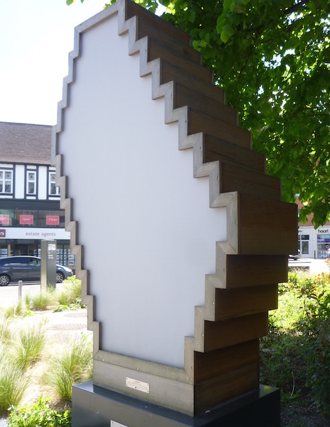
The quirky picture is a piece of public art at the top of the town and near those ‘words in the pavement’ featured the other week. What is this and who does it commemorate?
If you know where this week’s mysteries are, please leave a reply in the box below – and include extra details if you have them.
They will be published along with two more mystery images at about the same time next week. Good luck.
Responses to Where Is This? No.211
Leave a Comment Cancel reply
Please see our comments policy. All comments are moderated and may take time to appear. Full names, or at least initial and surname, must be given.Recent Articles
- Thames Water Faces £122 Million Penalty Following Ofwat Inquiry
- New Knife Crime Strategy for Surrey Announced
- Public Asked for Views on SCC’s Proposal for Reduced Speed Limits
- Guildford Healthcare Staff Celebrated for Transformative Mental Health Support
- Will the Government Help Save Community Pubs? Asks Surrey MP
- A Lighthouse in the Centre of Town Showing the Way to Community
- Letter: SCC Directs Weedkilling Policy
- Library Gets Lottery Grant To Raise Awareness of Green Issues
- Story of Wartime Canadian Army Entertainment Unit Based at Down Place, Guildford
- Flashback: Around the Very Top: Slow Progress to Our First Remote Stop


Recent Comments
- J Holt on Millions of Taxpayer Money Recovered from Railway Fare Dodgers
- J Holt on Summary of GBC Planning Decisions – May 21, 2025
- Kit Collins on Letter: Is This the Ugliest Building in Guildford?
- Barbara Ford on Notice: Have a Blooming Picnic – June 7
- M Durant on Millions of Taxpayer Money Recovered from Railway Fare Dodgers
- Jim Allen on Letter: If GBC Wishes To Be Nature-friendly, Stop Spraying Weedkiller
Search in Site
Media Gallery
Dragon Interview: Local Artist Leaves Her Mark At One of England’s Most Historic Buildings
January 21, 2023 / No Comment / Read MoreDragon Interview: Lib Dem Planning Chair: ‘Current Policy Doesn’t Work for Local People’
January 19, 2023 / No Comment / Read MoreA3 Tunnel in Guildford ‘Necessary’ for New Homes, Says Guildford’s MP
January 10, 2023 / No Comment / Read More‘Madness’ for London Road Scheme to Go Ahead Against ‘Huge Opposition’, Says SCC Leader
January 6, 2023 / No Comment / Read MoreCouncillor’s Son Starts Campaign for More Consultation on North Street Plan
December 30, 2022 / No Comment / Read MoreCounty Council Climbs Down Over London Road Works – Further ‘Engagement’ Period Announced
December 14, 2022 / No Comment / Read MoreDragon Interview: GBC Reaction to the Government’s Expected Decision to Relax Housing Targets
December 7, 2022 / No Comment / Read MoreHow Can Our Town Centre Businesses Recover? Watch the Shop Front Debate
May 18, 2020 / No Comment / Read More







Dave Middleton
May 26, 2016 at 12:48 pm
The street scene is the A3100 Portsmouth Road at Guildford at the junction with the bottom of the High Street.
Bury Street can be seen leading away from the photographer’s viewpoint.
The Large office was Buryfields House, which was a headquarters for the National Grid, demolished in the mid-1990s and still a vacant development site.
Bottom left is the George Abbot pub, formerly the Greyhound.
Also visible bottom left is part of St Nicolas Church.
The white and brick building in the foreground is Portsmouth House, currently occupied by Spring Personnel.
Tucked between the next office block and the old Buryfields House is the old Cannon pub, now known as The Keystone for some reason.
The modern art sculpture is located outside the new civic hall (G Live) on the London Road at Guildford and this link has information about it:
http://www.collaborativecity.com/qa-about-amenity-spaces-new-responsive-lighting-sculpture/
Andrew Backhurst
May 26, 2016 at 3:49 pm
A doddle this week, looking up Bury Street from Park Street. The big office building has long since been demolished and is currently a brownfield site awaiting further development.
Janice Miles
May 26, 2016 at 6:58 pm
Top picture shows Burymead House with it’s annexe below and the old Canon pub between the two of them.
Carol Norris
May 26, 2016 at 7:38 pm
Photo 1 : the building centre front on the corner of Bury Street used to be Ayres the Bakers.
Mr Ayres drove a Rolls Royce and we called it the Bread Rolls.
The William and Mary house with the Georgian front is Westbury House where my family lived for many years till 1972.
Opposite the house, the large office building was at one time the Central Electricity Generating Board and before that it was the site of my father’s company, Guildford Glass & Metal Works.
On the left side almost next to St Nicolas Church was Bateman’s Opticians and then there are Lovejoys Almshouses.
John Lomas
May 26, 2016 at 11:04 pm
The old picture shows the junction of Portsmouth Road with High Street.
Bury Street is showing just left of centre in the picture. the end of the St Nicolas clerestory can be seen over today’s George Abbot’s roof.
The building in the centre is now Spring Personnel.
I think the photo would have been taken from the roof of the large building which stood in the fork of Park Street and Farnham Road and the buildings lower right are now Whittingtons and Bombay Spice.
The quirky picture would appear to be outside G Live. I have seen it described as a light sculpture, so is that what was erected to celebrate the 2012 Olympic Torch Relay?
Ray Springer
May 27, 2016 at 7:49 pm
This is the bottom of Portsmouth Road at the junction with the High Street.
St Nicolas church is just visible at the left of the picture.
The office building, now demolished is the Central Electricity Generating Board (CEGB) headquarters.
The pub on the right of the picture was then called the Cannon.
The quirky picture of the public art is just outside G-Live in London Road at the top of the High Street.
Bill and Doug Staniforth
May 31, 2016 at 5:12 pm
The office was Mark Knight’s former place of employment– the CEGB building on Portsmouth Road.
The white fronted building used to be Ayer’s bakers, the Cannon pub was next to the CEGB then Jackson Cycles.
The public art is by G Live, it probably commemorates the tomb of the unknown speedboat captain or, almost certainly, something else.
That’s what we like – definitive answers. From our dear spanner monkeys or, almost certainly, someone like that. Ed
Margaret Cole
June 1, 2016 at 2:34 pm
The first picture shows the building at the bottom of Portsmouth Road and Bury Fields which used to be Ayres Restaurant and Gasgoine Pees estate agents with Westbury House in the background.
The interactive light sculpture is named Cedar, outside G Live, it was inspired by Alan Turing and it relays text messages visually, using 26 lights embedded in the sculpture that represent the letters of the alphabet, changing colour every 24 hours similar to the German Enigma Code.
Chris Townsend
June 1, 2016 at 3:01 pm
The 1980s view is dominated by Burymead House, the CEGB site featured in Where Is This? No.152:
https://guildford-dragon.com/2015/03/18/where-is-this-no-152/
A planning application has been submitted (ref.16/P/00923) for 103 apartments, assisted living accommodation for older people, the large site having been a wasteland for many years.
At the foot of the view is the junction of High Street, Bury Street, Portsmouth Road and Park Street, with St Nicolas Church on the left. The Cannon pub is just visible by the crossing on Portsmouth Road.
I haven’t seen the odd-shaped public art, but given its location, my guess is that it’s connected with the recent development at Turret House at the junction of Epsom Road and Jenner Road. If so, then it might represent the structure of the smallpox virus, commemorating Edward Jenner and his developments in smallpox vaccination.
P Phillips
June 2, 2016 at 3:10 pm
The site of the old Guildford Glass & Metal Works was I believe once Lacells & Tikners brewery.