- Stay Connected

Socialize

 Abraham Lincoln
If given the truth, the people can be depended upon to meet any national crisis...
Abraham Lincoln
If given the truth, the people can be depended upon to meet any national crisis...

 Guildford news...
for Guildford people, brought to you by Guildford reporters - Guildford's own news service
Guildford news...
for Guildford people, brought to you by Guildford reporters - Guildford's own news service
Where is This? No.232
Published on: 27 Oct, 2016
Updated on: 27 Oct, 2016
By David Rose
I was hoping there would be a sizeable electronic postbag of replies to last week’s mystery pictures and I was not disappointed!
Plenty of replies to the vintage picture that showed North Street – many readers naming the shops and businesses in view and identifying the vehicles. Thanks to all of you.
The quirky picture proved a little harder. It is in Jacobs Well, near the village hall, and is a ‘well’ that was placed there to commemorate the Millennium. A number of replies gave details of it.
So click here to see last week’s post and all the replies and the details given.
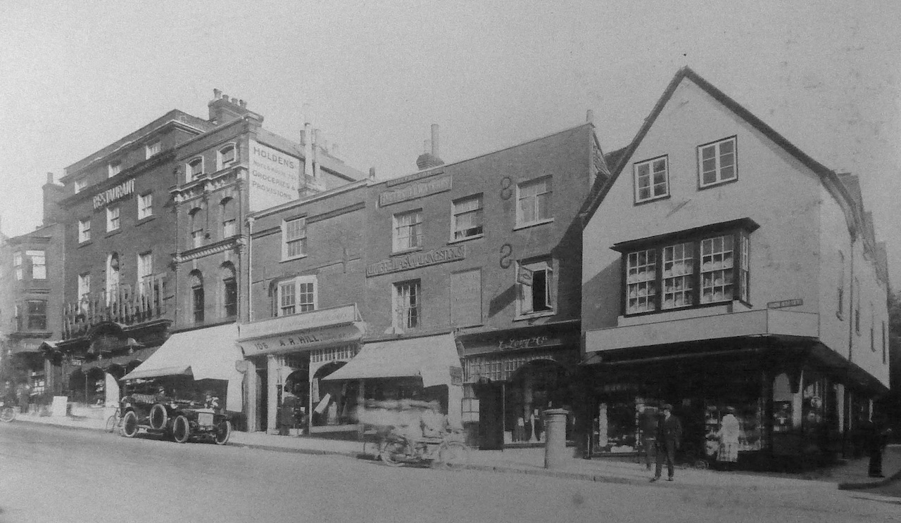
Do you recognise this view in Guildford town centre? Click to enlarge in a new window.
This week’s mystery vintage picture shows a view in the town centre taken in the 1920s and from the archives at the Guildford Institure. Do you know where and can you add some details?
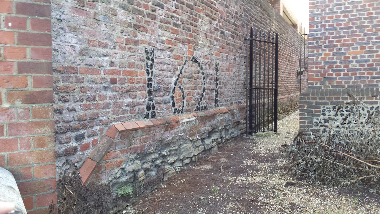
Where can this be found? Click to enlarge in a new window.
The quirky picture shows a date inlaid into a wall in the town centre. This may be a bit of a difficult one. The clue is that it relates to a well known almshouse.
If you know the answers to this week’s mysteries, please leave a reply in the box below – and include extra details if you have them.
They will be published along with two more mystery images at about the same time next week. Good luck.
Share This Post


Responses to Where is This? No.232
Leave a Comment Please see our comments policy. All comments are moderated and may take time to appear. Full names, or at least initial and surname, must be given.

I'm living well for nothing at all! (See: No Trifling Matter: Magpie Trapped in Godalming Sainsbury’s)


Next stop, Debt Chasm! (See: We Should All Be Outraged About the Failure to Deal with Legacy Debt)


Bernard Parke
October 27, 2016 at 7:35 am
The Restaurant was Bretts which later became the site of Woolworths.
Dave Middleton
October 27, 2016 at 12:51 pm
The street scene is the lower end of Guildford High Street, with the junction of Quarry Street at the extreme right.
The building on the right of the picture is now Thomas Cook’s, the travel agent and was formerly home to WHSmith, before they moved a few doors up the High Street into the building shown as a restaurant in the picture.
The next two buildings up the hill have been remodelled or rebuilt since the picture was taken, but the building housing Holden’s grocers between them and the current WHSmith hasn’t changed much at all – in fact the old painted signage on the high wall is still just about visible.
No comment on the quirky picture!
Dave Middleton
November 4, 2016 at 11:11 am
I forgot to mention that the Thomas Cook building, previously occupied by WH Smith, still has the name WH Smith carved into the wooden beam that projects out from the front of the building.
Also, before WH Smith and Margaret Cole’s “Old Blue China Shop” pictured, the building was, in 1905, home to Angell & Son, long before they moved to Woodbridge Road at the junction with Onslow Street. In 1905, the shop had a very sturdy looking flagpole fixed to the front gable end above the first floor window.
Sue Warner
October 27, 2016 at 3:32 pm
Guildford High Street and to the right of the picture is Quarry Street.
Carol Norris
October 27, 2016 at 4:49 pm
Picture 1 : High Street and corner of Quarry Street. The building on the corner was once WH Smith and before that, I think it was Boots the Chemist.
There was a lending library upstairs which had a very creaky wooden floor.
I seem to recall changing my grandmother’s books there probably around the late 1940s.
Is the tall building a bit further up the High Street Holden’s the grocers?
John Lomas
October 27, 2016 at 6:51 pm
The old picture shows the High Street from Quarry Street up towards Chapel Street.
I think the gap above Holdens is the Shambles, strangely not a name I remember, though I believe there was a bookshop which had a side entrance into it as well as a main entrance onto High Street.
While talking of that area, what was the cafe and roast coffee shop on that part of High Street in the 1950s?
I think the car might be a Daimler.
The date of 1621 is significant for Abbot’s Hospital, although I haven’t managed to find where it is.
Mike Williams
October 27, 2016 at 7:06 pm
The building on the right is on the corner of High Street and Quarry Street.
Many will remember the WHSmith shop with open bookstall trading here. But as this did not open until 1929, the photo must have been earlier as David says.
Is the wrought iron gateway between The Bars and Martyr Road?
Keith Childs
October 28, 2016 at 5:46 pm
The first is at the junction of the High Street and Quarry Street but as a relative newcomer to Guildford I cannot give more details.
The mystery picture is of the inside of the boundary wall of Abbot’s Hospital and 1621 is the date when this wall was built.
The first residents of the hospital arrived in 1622.
John Thorp
October 29, 2016 at 10:44 pm
I was going to identify the location in the lower High Street as being from where WHSmith used to be, to where they are today.
But then I spotted another shop just visible on the left-hand end of the row.
That was my grandfather’s bookshop, located where Gap is today.
In those days the family lived above the shop and my aunt told me that her bedroom overlooked the street.
There were quite a few public houses in the High Street then, including one just opposite the shop and she said that she often watched out of the window at the antics at chucking out time.
Margaret Cole
November 1, 2016 at 9:41 am
The first picture shows 46 High Street, which had a few changes of traders. The old blue China Shop then WWSmith and Thomas Cook.
The second one I believe is off North Street behind the Old Cloth Hall part of Abbot’s Hospital. The date 1621 referring to George Abbot’s accident in shooting a gamekeeper or something like that. I’m not much of a historian but I keep trying!
Bill and Doug Staniforth
November 1, 2016 at 12:34 pm
Picture 1 is High Street at the corner of Quarry Street. On the corner was once WHSmith, now Thomas Cook.
Picture 2 is the rear of Abbot’s Hospital in North Street. The date on the wall is on the left-hand side and we’re pretty certain it’s Mick Giles’ birth year!
Chris Townsend
November 1, 2016 at 5:49 pm
The High Street view shows Brett’s, a long-established cook, confectioner and caterer, with the restaurant once a popular venue.
Woolworth’s occupied the site from 1927, and it’s now WHSmith. The 18th-century building is listed, and was originally a house.
Higher up the street, on the corner of The Shambles, Burton’s replaced the buildings on the left in 1929.
Charles Holden occupied the ornate shop, built in 1864 for his family’s grocer’s business by Henry Peak, the Guildford architect.
Maurice Quittenton’s umbrella and walking stick shop had several different locations in the town over the years, and operated “The County Umbrella Hospital, recovering and repairing on the premises”. J. Levy & Co. were tailors, and on the corner of Quarry Street was George Perridge’s china and glass shop, as featured in Where is This? no.42.
Abbot’s Hospital was built around 1621, so my guess is that the date is on one of its walls, perhaps beside the path from North Street where there’s some parking space.
Beyond the wall would be the buildings on Jeffries Passage.
David Godden
November 19, 2016 at 12:09 pm
Fascinating insight. Thanks.
Virginia Goodman
November 1, 2016 at 8:36 pm
I believe it’s the corner of Quarry Street and High Street.
The corner building (at least 40 years ago) was WHSmith.