 Abraham Lincoln
If given the truth, the people can be depended upon to meet any national crisis...
 Guildford news...
for Guildford people, brought to you by Guildford reporters - Guildford's own news service
Where Is This? No.26
Published on: 25 Sep, 2012
Updated on: 12 Oct, 2012
By David Rose
Some of the regular responders seems to have been stumped by last week’s pictures.
No such problems for Chris Townsend, Brian Holt, Ray Springer, and Doug Staniforth, and so on, who either correctly recognised either one or both pictures. Click here to see last week’s post and their replies at the foot of the page itself.
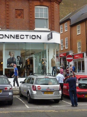
The answers are: the mystery photo was of the Guildford & District Co-op dairy in Woodbridge Road – the site now occupied by the Currys and PC World store.
The mystery date appears on the building in North Street on the corner with Market Street. Now the French Connection store, it was once Gammon’s store. And as Ray Springer noted, also once a Berni Inn (on the first floor). Whatever happened to Berni Inns? Does anyone know when they packed up? The Guildford one was still in existence in 1983 – probably the last time I went there!
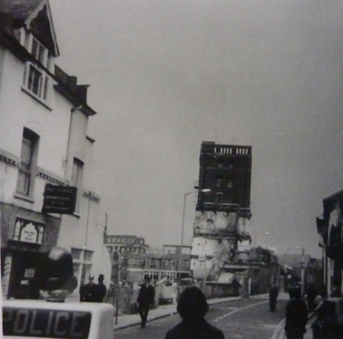
On to this week’s mystery picture. Can you name the street and the building in the centre standing all on its own? I guess some will be able to say what the occasion was and may be able to add some memories if they were there – Sunday, February 17, 1974, to be precise.
Until I find some more to photograph, I have run out of signs or buildings featuring dates – so we now move on to clocks. There are loads of them on buildings in Guildford.
Thanks to Alistair Fulton who has been out and about photographing them. Some are easy, some not so.
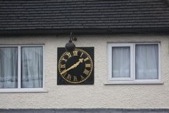
Here’s the first one – do you know where it is?
If you know the answers please leave a reply in the box below. All replies will be posted at about the same time next week, along with a new post with the answers to this week’s photo and mystery date, and the next pair of images.
Responses to Where Is This? No.26

Click on cartoon for Dragon story: Public Asked for Views on SCC’s Proposal for Reduced Speed Limits


Recent Articles
- Letter: Will GBC’s New Planning Document on Building Heights Be Effective?
- Proposed New Leisure Contract Should Improve Facilities and the Council’s Income
- Witness Appeal Following Fatal Collision
- Celebration at Guildford Cathedral of its Latest and Future Church Leaders
- Photo Feature: Now You See It…
- Letter: Snail-paced Progress for Full Weir Repair
- Mayor’s Diary: July 5 -July 20
- One Homeowner Recompensed but Fight Continues Over Waverley CIL Charges
- Letter: Fine Those Guilty of Anti Social Behaviour
- GBC Working Hard To Mitigate Looming Weyside Urban Village Deficit


Recent Comments
- Jan Messinger on Public Asked for Views on SCC’s Proposal for Reduced Speed Limits
- Fiona White on GBC Asks Residents for Views on Its Draft Building Height Guidance
- Dave Middleton on Letter: Fine Those Guilty of Anti Social Behaviour
- Carina Coverly on GBC Asks Residents for Views on Its Draft Building Height Guidance
- M Durant on Online Event Will ‘Help Residents Have Their Say On Local Government Reorganisation’
- Jim Allen on GBC Working Hard To Mitigate Looming Weyside Urban Village Deficit
Search in Site
Media Gallery
Dragon Interview: Local Artist Leaves Her Mark At One of England’s Most Historic Buildings
January 21, 2023 / No Comment / Read MoreDragon Interview: Lib Dem Planning Chair: ‘Current Policy Doesn’t Work for Local People’
January 19, 2023 / No Comment / Read MoreA3 Tunnel in Guildford ‘Necessary’ for New Homes, Says Guildford’s MP
January 10, 2023 / No Comment / Read More‘Madness’ for London Road Scheme to Go Ahead Against ‘Huge Opposition’, Says SCC Leader
January 6, 2023 / No Comment / Read MoreCouncillor’s Son Starts Campaign for More Consultation on North Street Plan
December 30, 2022 / No Comment / Read MoreCounty Council Climbs Down Over London Road Works – Further ‘Engagement’ Period Announced
December 14, 2022 / No Comment / Read MoreDragon Interview: GBC Reaction to the Government’s Expected Decision to Relax Housing Targets
December 7, 2022 / No Comment / Read MoreHow Can Our Town Centre Businesses Recover? Watch the Shop Front Debate
May 18, 2020 / No Comment / Read More


Bernard Parke
September 25, 2012 at 6:03 pm
1) Friary Tower
2) The horologist in the Worplesdon Road. opposite Seafare .
Malcolm Fincham
September 25, 2012 at 7:49 pm
The only major building work in the Guildford area back in 1974 [as a very young lad] was at the Friary so I would guess this to be a view down Commercial Road, which was then a bus stop area for London Country buses, but no idea what the occasion was?
The second picture, I’m sure, is above the horological shop, Worplesdon Road [opposite Byrefield road]
Ray Springer
September 26, 2012 at 7:36 pm
1974 photograph is of the demolition of the Friary Brewery to make way for the Friary Shopping Centre.
The Brewery was in an area between Onslow Street and Commercial Road. The tall building was the main tower in the brewery which was blown up (presumably on February 17th)
Brian Holt
September 27, 2012 at 2:57 pm
It is the demolition of the old Friary Meux Brewery in Commercial Road, which is now the bus station.
The clock is above the Horological Workshops in the Worplesdon Road, Stoughton which is next to the Total petrol station, and is directly opposite Byrefield Road.
Chris Townsend
September 29, 2012 at 4:55 pm
The mystery photo shows the demolition of the Friary Brewery, Commercial Road.
Darrol Radley
October 2, 2012 at 6:47 pm
The sad looking tower must be the final remains of the Friary brewery tower just before demolition on Onslow Street.