- Stay Connected

Socialize

 Abraham Lincoln
If given the truth, the people can be depended upon to meet any national crisis...
Abraham Lincoln
If given the truth, the people can be depended upon to meet any national crisis...

 Guildford news...
for Guildford people, brought to you by Guildford reporters - Guildford's own news service
Guildford news...
for Guildford people, brought to you by Guildford reporters - Guildford's own news service
Where is This? No.277
Published on: 21 Oct, 2017
Updated on: 21 Oct, 2017
By David Rose
All but one of the replies to the previous vintage picture correctly identified the location as Onslow Street, and roughly where the goods entrance to the Friary Centre is today.
Similar views of this street have been featured before, but this one appears to have been taken from some height on a building opposite.
Suggestions in the replies included from the gas works, Jackson’s motor garage or the then new Bedford Road car park.
In his suggestions, John Lomas referred to a picture that was featured in the forerunner of this column, Can You Identify These Locations? No.27, in 2012, that was originally published on the St Catherine’s Village website, with all posts transferred to the Dragon when it was established.
Although that picture does not display now (a technical glitch we can’t fix), the view was of Onslow Street but believed to have been taken from near to what is now part of the Casino nightclub complex.
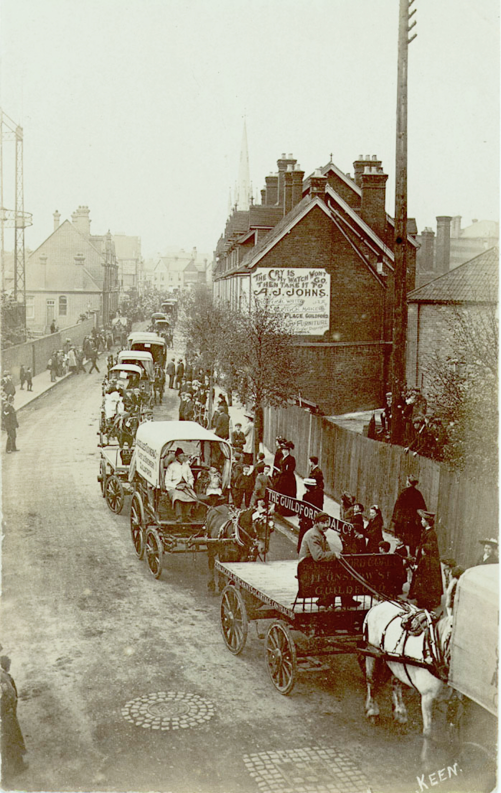
A view of Onslow Street that was previously featured as a mystery picture in 2012. Click on pictures to enlarge in a new window.
Here is that picture. It features a horse show parading through Guildford in about 1910.
The sundial featured as the quirky picture in the previous post can be found in the Castle Cliffe Gardens, between Quarry Street and Castle Hill. Not an easy one at all!
Click here for last week’s post and all the replies at the foot of it.
Where is this?
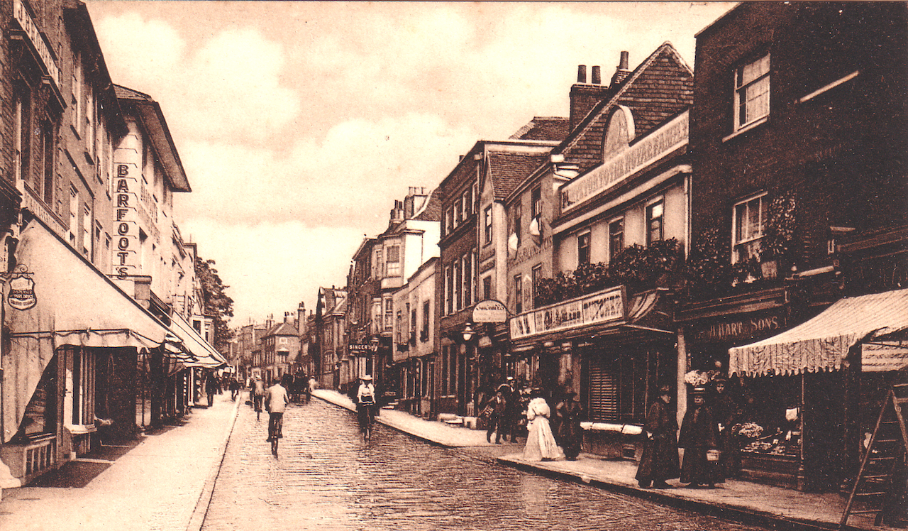
This week’s mystery vintage picture is an Edwardian postcard view taken in the town centre. As a clue the buildings on the left have gone, while most of those on the right still stand. Do you know where this is?
And do you know where this is?
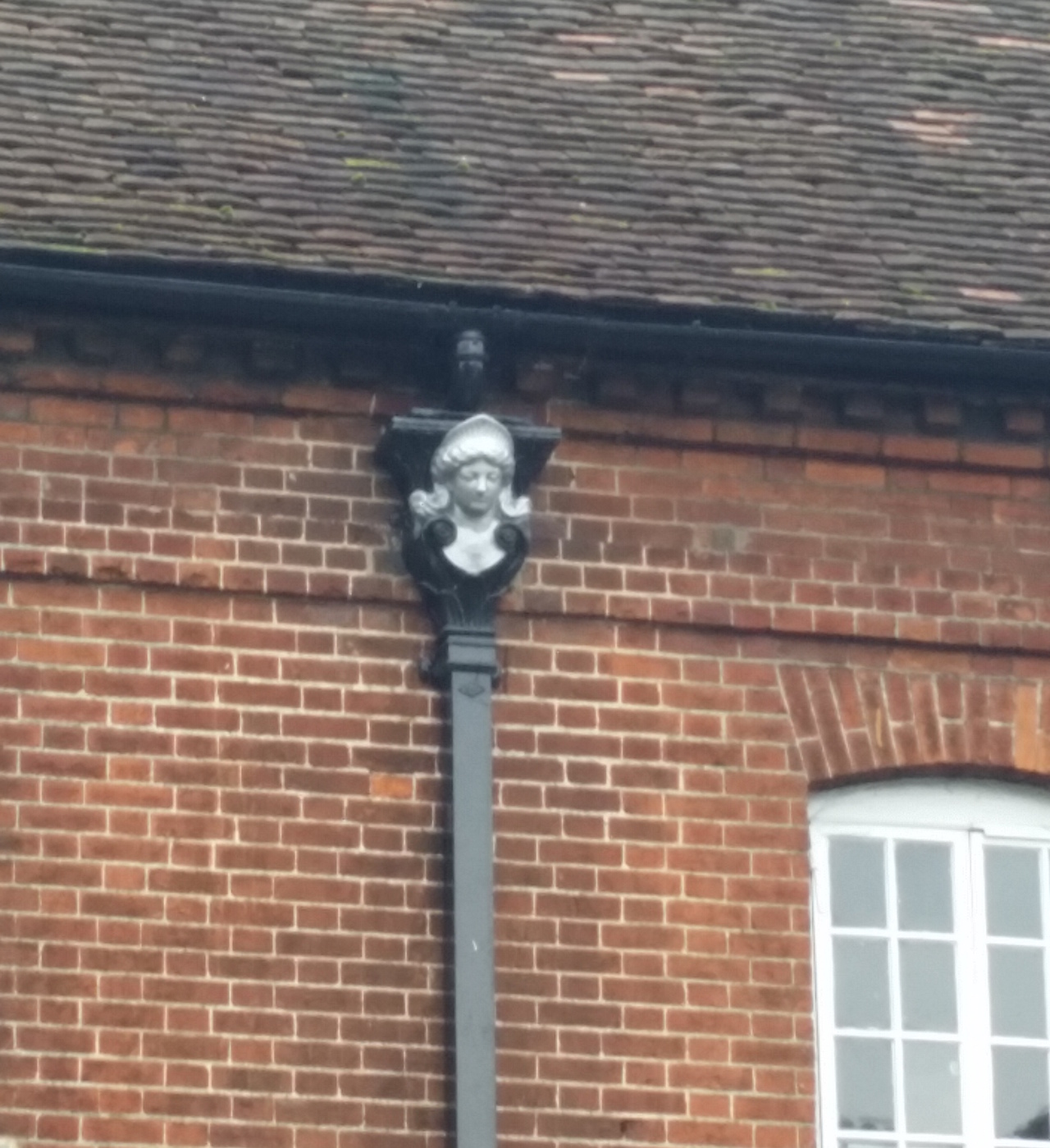
The quirky picture was taken by reader Jan Messinger. I hadn’t noticed this feature, attached to a drain hopper on a distinctive Guildford building, close to to the town centre and near an entertainment venue.
If you know the answers and perhaps can add some more details, please leave a reply in the box below. I’ll give the answers in two week’s time.
Share This Post


Responses to Where is This? No.277
Leave a Comment Please see our comments policy. All comments are moderated and may take time to appear. Full names, or at least initial and surname, must be given.

I'm living well for nothing at all! (See: No Trifling Matter: Magpie Trapped in Godalming Sainsbury’s)


Next stop, Debt Chasm! (See: We Should All Be Outraged About the Failure to Deal with Legacy Debt)


Dave Middleton
October 22, 2017 at 1:37 am
The street scene is the lower part of the upper High Street, if that makes sense. The photographer would’ve been standing roughly level with Rymans, looking East. All the buildings on the left of the picture were demolished when the road was widened.
The rain hopper is on the Mill Studio, near the Yvonne Arnaud Theatre.
Brian Holt
October 23, 2017 at 9:50 pm
This picture taken in early 1900s is the view from Ram Corner looking along Upper High Street.
On the right side of the road behind the lamp-post the shop sign is Singer and the Royal Grammar School next door. On the left is all new shops now.
The drain hopper is on the front of the old Town Mill, next to Yvonne Arnaud Theatre, Millbrook.
Chris Townsend
October 26, 2017 at 9:22 pm
The postcard view is of Upper High Street; the trees were beside the historic Allen House, which was set back from the road, opposite the Royal Grammar School.
After the buildings on the left in the old view were demolished about 1959, the street was widened, leaving the pillared porch of Allen House encroaching on the new pavement.
The house remained for a short time, next to the present Norfolk House, but was demolished about 1963, the Royal Grammar School’s new building having been built in the grounds of Allen House.
According to a 1905 Kelly’s Directory, Edward Strelley Barfoot had a furnishing warehouse. He was the son of Joseph Whittaker Barfoot who founded the Surrey Advertiser in 1864.
In the 1950s, the building housed the town’s art gallery.
On the right of the view, Singer’s occupied the same site until at least 1957. That looks like Quittenton’s umbrella and walking stick shop right of centre. The gateway next to it leads to Baker’s Yard.
Henry Gale, butcher, “Purveyor to the Royal Family”, had come to Guildford about 1888. Some readers will remember Mercer’s butchers on that site. Ambrose Hart was a fruiterer and nurseryman.
I’m not certain, but I think the quirky picture is of the Toll House, where the turbine is installed, beside the Town Mill.
Ron North
October 27, 2017 at 2:08 pm
Upper High Street (Spital street) – Barfoot’s Paperhanging and Decorative Warehouse (demolished in the 1950s) is on the the left.
Joseph Whitaker Barfoot (owner) was founder of the Surrey Advertiser in 1864.
Ron North
October 27, 2017 at 8:37 pm
The quirky picture is a feature located on the Town Mil near the Yvonne Arnaud Theatre.
John Lomas
October 29, 2017 at 11:49 am
I think the old picture is showing the top section of High Street as the bend is leading to the North Street junction.
The gutter bucket is on the old Town Mill where the access to the Yvonne Arnaud Theatre is.
J E Davey
October 31, 2017 at 11:22 pm
I think this shows the upper high street. The left-hand side is now Norfolk House and on the right, opposite “Barfoots”, can be seen the entrance to Bakers Yard, which leads through to Sydenham Road.
Doug and Bill Stanniforth
November 3, 2017 at 11:33 am
Upper High Street. Once known as Spital Street. Barfoot’s Paperhanging and Decorative Warehouse is on the left.
The quirky picture is of the Mill Studio, Millbrook.
Just to remind the Ed. Has he put his clocks back 1 week instead of 1 hour? This would explain the delay in the answers of “Where is this?”