- Stay Connected

Socialize

 Abraham Lincoln
If given the truth, the people can be depended upon to meet any national crisis...
Abraham Lincoln
If given the truth, the people can be depended upon to meet any national crisis...

 Guildford news...
for Guildford people, brought to you by Guildford reporters - Guildford's own news service
Guildford news...
for Guildford people, brought to you by Guildford reporters - Guildford's own news service
Where Is This? No.57
Published on: 15 May, 2013
Updated on: 15 May, 2013
By David Rose
The view of St Catherine’s Lock on the Godalming Navigation didn’t pose a problem to all of you who replied to last week’s mystery photograph. I think the picture postcard would date to about 1910.
In the book The Wey Navigations by Alan R Wardle, published by the Surrey Industrial History Group in 2003 (essential bedtime reading for waterways enthusiasts), the author notes of St Catherine’s Lock: “St Catherine’s Cut, about 700 yards long and almost straight, made a much shorter and deeper channel for barges. The lock, half way along, was originally constructed of timber but was rebuilt in concrete in 1909. The fall of water through the lock is small – about 3 feet – and initially there was no provision to by-pass surplus water. The sluice, the channel around the lock and the cart bridge over it are alterations made under the the RWIS programme.” Note: The River Wey Improvement Scheme took place in the 1930s.
Some lovely comments by those who left a reply, click here see them at the foot of last week’s post. Many will remember the place near St Catherine’s Lock called Three Oaks where people used to swim.
And interesting to read that Peter Holt mentions the Shalford Junction signal box. I have recently copied some photos of the box, including pictures of the signalman who was there for many years and the house he and his family lived in that was adjacent to it. A story with photos will appear under the Through Time section of The Guildford Dragon NEWS soon.
The mystery statue is indeed in Quakers’ Acre off North Street. If Bernard Parke is right and the Victorian artist George Frederick Watts (1817-1904) is buried there, the people at Watts Gallery in Compton will be very interested, as his final resting place is normally said to be Compton Village Cemetery! Perhaps there was another person with the same name?
Should you want to read a little more about Quakers’ Acre and the history of the Quaker movement in Guildford, click here.
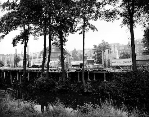
Do you know which building stands here today?
This week’s mystery photo is again a riverside location, nearer to the town this time. What’s being built here then?
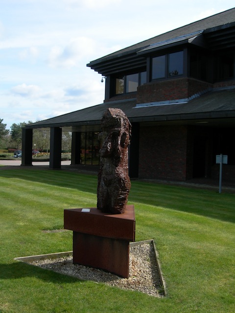
Where can this piece of public art be found?
And the mystery piece of public art, photographed by Peter Bullen… do you know where it is?
If you know the answers to this week’s, and perhaps have some comments to make, please leave a reply in the box below. All replies will be posted at about the same time next week, along with a new post with the answers to this week’s vintage photo and sculpture / statue picture, and the next pair of images.
Share This Post


Responses to Where Is This? No.57
Leave a Comment Please see our comments policy. All comments are moderated and may take time to appear. Full names, or at least initial and surname, must be given.

I'm living well for nothing at all! (See: No Trifling Matter: Magpie Trapped in Godalming Sainsbury’s)


Next stop, Debt Chasm! (See: We Should All Be Outraged About the Failure to Deal with Legacy Debt)


Matthew Linegar
May 15, 2013 at 6:54 am
I reckon it’s the guidlford boat house? You can see the mill on the background.
Matt
Bernard Parke
May 15, 2013 at 9:06 am
1) Yvonne Arnaud in construction
Ray Springer
May 15, 2013 at 11:08 am
The Yvonne Arnaud Theatre in Millbrook. Designed by Guildford Architects Scott Brownrigg & Turner, and built by Marshall-Andrew, it was opened on 2nd June 1965
Peter Bullen
May 15, 2013 at 11:28 am
Yvonne Arnaud Theatre, one the site of the old iron foundry?
John Lomas
May 15, 2013 at 1:04 pm
That is the site of the Yvonne Arnaud Theatre.
This dates from after I left the area. The North Street Repertory Theatre was still active then.
David & Ann Bailey
May 15, 2013 at 1:49 pm
The building being constructed is the Yvonne Arnaud Theatre. The building in the picture is the Town Mill.
Norman Hamshere
May 15, 2013 at 10:02 pm
Yvonne Arnaud Theatre under construction.
Julia Funnell
May 15, 2013 at 10:37 pm
1) Looks like the Town Mill with St Mary’s to the left, so I think the answer is the Yvonne Arnaud Theatre.
2)This is outside the BOC building in Priestley Road on the Research Park.
Brian Holt
May 19, 2013 at 5:28 pm
This is where the Yvonne Arnaud Theatre stands. You can see the town-mill in the background.
The site was used for an iron foundry until that was demolished in 1941. It then became a speedway track, the home of the Millmead Monarchs. As children we attended their race meetings.
The theatre opened in 1965.
Chris Townsend
May 19, 2013 at 6:11 pm
The building site is that of the Yvonne Arnaud Theatre, opened in 1965.
The land at Mill Mead was, in Victorian times, occupied by Filmer & Mason’s Iron Foundry, later by Dickenson & Byrne, and then by Blackburn & Co. It was approached from Mill Lane.
After the foundry was closed and demolished, in about 1941, the land was used as a dirt-track for motorcycle racing.
Doug Staniforth
May 21, 2013 at 4:12 pm
It’s the Yvonne Arnaud Theatre constructed by Marshall Andrew
Pass