 Abraham Lincoln
If given the truth, the people can be depended upon to meet any national crisis...
 Guildford news...
for Guildford people, brought to you by Guildford reporters - Guildford's own news service
Where Is This? No.66
Published on: 16 Jul, 2013
Updated on: 16 Jul, 2013
By David Rose
Readers with good memories of Guildford’s pubs and a couple of eagle-eyed bus enthusiasts were among those who replied to last week’s post.
The pub was indeed the Dolphin and in the photo of it an Aldershot & District Dennis Lancet bus can be seen.
Click here to see last week’s post and all the replies at the foot of it.
The mystery piece of public art can be found at the University of Surrey. And thanks to David and Ann Baily who added that it is on the former Surrey Satellite building.
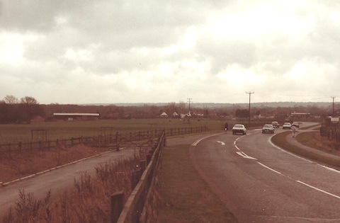
This week’s mystery vintage photo is a colour print, so it can’t be too old, but how this view has changed.
The picture dates to January 1984. The road is as it is now – even the slip road leading to the A3 for emergency vehicles is the same. The houses in the far distance still stand. There was once a farm here, now there’s houses and a large store. Can you work out where this is, or recognise the view?
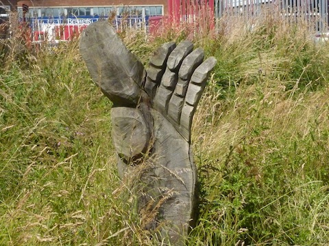
The picture of a piece of public art was taken by me this week. It is one of a number of wooden carvings in the same area. What can you add?
If you know the answers to this week’s, and perhaps have some comments to make, please leave a reply in the box below. All replies will be posted at about the same time next week, along with a new post with the answers to this week’s vintage photo and sculpture / statue picture, and the next pair of images.
Responses to Where Is This? No.66
Leave a Comment Cancel reply
Please see our comments policy. All comments are moderated and may take time to appear. Full names, or at least initial and surname, must be given.Recent Articles
- Home-to-School Transport Refused
- Devolution: Ministry Asks for Clarification of How £5 billion Debt Will Be Managed
- Website Maintenance
- Letter: The Younger Generations Might Learn from Our Experience
- Final Steam Train Signalled by Farncombe, Petersfield and Haslemere Signal Boxes
- New Toucan Crossing on Woking Road to Facilitate Weyside Urban Village Project
- Updated: Honesty Questioned as Waverley Scraps Ground Maintenance Deal
- Letter: Please Send Nominations for Design Awards
- Notice: Do You Need Nature on Prescription?
- Mayor’s Diary: April 27 – May 11


Recent Comments
- Ricky Sonn on Wildlife Group Plans To Release Beavers To Revive Surrey Wetlands
- David Roberts on Letter: The Younger Generations Might Learn from Our Experience
- Jim Allen on Devolution: Ministry Asks for Clarification of How £5 billion Debt Will Be Managed
- Martin Elliott on New Toucan Crossing on Woking Road to Facilitate Weyside Urban Village Project
- Helen Clear on Letters, Comments, Complaints Policy and Privacy Statement
- Frank Emery on Royal Surrey Patients Complain Changes Won’t Fix Underlying Parking Problem
Search in Site
Media Gallery
Dragon Interview: Local Artist Leaves Her Mark At One of England’s Most Historic Buildings
January 21, 2023 / No Comment / Read MoreDragon Interview: Lib Dem Planning Chair: ‘Current Policy Doesn’t Work for Local People’
January 19, 2023 / No Comment / Read MoreA3 Tunnel in Guildford ‘Necessary’ for New Homes, Says Guildford’s MP
January 10, 2023 / No Comment / Read More‘Madness’ for London Road Scheme to Go Ahead Against ‘Huge Opposition’, Says SCC Leader
January 6, 2023 / No Comment / Read MoreCouncillor’s Son Starts Campaign for More Consultation on North Street Plan
December 30, 2022 / No Comment / Read MoreCounty Council Climbs Down Over London Road Works – Further ‘Engagement’ Period Announced
December 14, 2022 / No Comment / Read MoreDragon Interview: GBC Reaction to the Government’s Expected Decision to Relax Housing Targets
December 7, 2022 / No Comment / Read MoreHow Can Our Town Centre Businesses Recover? Watch the Shop Front Debate
May 18, 2020 / No Comment / Read More


Barbara Howarth
July 19, 2013 at 12:43 pm
Crumbs can that really be the A3 at Burpham? Never seen a photo of it “before”. If so Sainsbury’s and the Weybrook Estate, on which I live, are now here, built around 1987. I’ve heard older locals say it used to be farmland, recognised in the street names now: Dairymans Walk, Jersey Close, etc.
And the wooden sculpture is one of those quirky ones down by the river at Woodbridge Meadows. Given away by the visible Brewers sign!
Bibhas Neogi
July 20, 2013 at 7:43 pm
This is Clay Lane looking south at just south of Clay Lane bridge over the A3
Sue Bushell
July 22, 2013 at 8:03 am
Could this view be of the A3 coming towards Guildford with the exit from the Hog’s Back on the left? If so the view now is of the Surrey Research Park and new sports facility.
I remember as a young girl walking across the fields from Park Barn with my aunt and following a path alongside this road one summer’s evening, not something one would do now!
The wooden hand is down by the river in Walnut Tree Close opposite Screw Fix, I do not know anymore about this I’m afraid.
david & ann bailey
July 22, 2013 at 11:50 am
We think it is the old A3 at Burpham, the farm was Bowers and the cottages were Bowers cottages and the large store would be Sainsbury’s.
The sculpture is on the river bank at Woodbridge Meadows, you can see Brewers in the background.
Chris Townsend
July 22, 2013 at 9:00 pm
I think the view is of the A3 through Burpham, looking towards Guildford. If that’s so, then the farm could be Bower’s Farm, where Weybrook Park has since been built, and the store Sainsbury’s, Clay Lane.
The sculpture is one of a number at Woodbridge Meadows created in 2008 by the Treepirates, wood carvers, from tree stumps and logs left over from clearance work there.
Brian Holt
July 22, 2013 at 10:39 pm
I think this is Burpham, looking towards Guildford, and the slip road on the left, was where the Ministry of Transport, had a weighbridge, and used to pull lorries and coaches for spot checks.
The houses are at the bottom of Merrow Lane.
On the right of the photo,where there is a pedestrian, is an entrance to Sutton Place.
Sainsbury’s store would be in the distance today.
The carved hand is in Woodbridge Meadows near the river, and the photo was taken looking towards the Royal Mail sorting office fence, With Brewers in the background.