- Stay Connected

Socialize

 Abraham Lincoln
If given the truth, the people can be depended upon to meet any national crisis...
Abraham Lincoln
If given the truth, the people can be depended upon to meet any national crisis...

 Guildford news...
for Guildford people, brought to you by Guildford reporters - Guildford's own news service
Guildford news...
for Guildford people, brought to you by Guildford reporters - Guildford's own news service
Where Is This? No.102
Published on: 26 Mar, 2014
Updated on: 26 Mar, 2014
By David Rose
Last week’s mystery photo location showing a Safeguard bus was identified by many as the former Onslow Street bus station. It’s now the open space near the Electric Theatre and where all the wannabe young musicians hang out while awaiting their lessons to start at the Academy of Contemporary Music in the upper floors of the Rodboro Buildings.
In that picture the word ‘GUILDFORD’, that formed the bus station sign can be seen on what was then the empty shell of the former electricity works building – now the Electric Theatre, with the Rodboro Buildings just in view on the right.
The quirky modern day photo shows the grotto-like feature that is in the Castle Grounds. Yes, it is similar to the bricked-up ‘cellars’ that can be seen in Millbrook, which some people suggested.
Some comments about secret tunnels used by smugglers and the like linked to the High Street, etc. No-one knows if any of that is true. Any more stories and observations gratefully received.
Click here to see last week’s post and all your replies with, as usual, lots of extra information.
I like John Lomas’ comments about the buses and their respective numbers that ran to and from Stoughton. I think the 28 has long disappeared, but Arriva’s 26 still operates, but the route is different from the original Aldershot & District one. I used that many times. We used to joke that if you went upstairs on the double decker and sat at the back you would get your money’s worth with a longer ride! Some people believed us…
Also, I forgot last week to name the location of the quirky photo of the ball of mistletoe in a tree featured the week before. I have now added the location – Woodbridge Road, nearly opposite the Drummond pub.
I’d just like to say that all who correctly identified the locations now automatically become members of the exclusive local history appreciation society – the Guildford Anoraks.
Any new readers who wonder what on earth all the correspondence about speedboats is about … well it’s to do with a plea for some kind of prize for correctly identifying the images. Speedboats being the regular prize on the old TV game show Bullseye.
Here I have to thank regular reader Peter Holt for the model boat he has donated to me. Made by the Guildford model maker Victory Industries, it’s now the latest addition to my collection of old things to do with Guildford. And thanks Peter for the model railway wagons with a Guildford connection and the old lemonade bottle of the Castle Brewery. I’ll feature these in a Through Time story soon.
Perhaps us Guildford Anoraks need to find a venue for our next party conference. Might be the boating lake in Stoke Park and I can put that boat on the water and see it cruise across the lake!
Here’s this week’s mystery vintage photo…
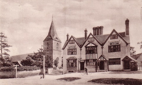
Do you recognise this view taken in the 1900s?
It shows a pub and church in what was then (the 1900s) a village on the outskirts of Guildford. The pub was owned by Mellersh & Neale – a Reigate brewery; so back then the Guildford breweries didn’t have a complete monopoly of tied houses in the area. Do you know where this is?
The quirky photo is courtesy of my good friend Dan James, whose wonderful images are regularly featured here in his own section. Click here to view.
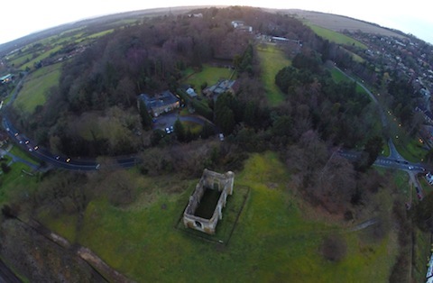
A bird’s eye view of what?
He has a radio-controlled miniature helicopter, called a drone, with a tiny camera attached. I asked him to take some unusual aerial photos over Guildford, as this is one of them. Do you recognise where this is? The ruined chapel is a clue.
If you think you know the answers, please leave a reply in the box below. The answers, along with the next pair of images, will be published about the same time next week.
Share This Post


Responses to Where Is This? No.102
Leave a Comment Please see our comments policy. All comments are moderated and may take time to appear. Full names, or at least initial and surname, must be given.

I'm living well for nothing at all! (See: No Trifling Matter: Magpie Trapped in Godalming Sainsbury’s)


Next stop, Debt Chasm! (See: We Should All Be Outraged About the Failure to Deal with Legacy Debt)


Andrew Barr
March 26, 2014 at 6:53 am
The pub is The Horse and Groom with St John’s Church in Merrow.
The aerial photo is St Catherine’s Chapel.
Bernard Parke
March 26, 2014 at 7:22 am
1) Horse and Groom at Merrow.
2) Aerial view of of St Catherine’s Chapel.
Chaz Folkes
March 26, 2014 at 11:39 am
The first picture is a view of Merrow showing the Horse and Groom and the church of St John The Evangelist before the road layout got complicated.
The second picture is of St Catherine’s Hill off Ferry Lane.
Mary Bedforth
March 27, 2014 at 9:32 am
1. Horse and Groom, Merrow.
2. St Catherine’s.
Hope that drone thing comes nowhere near my garden on a nice sunny day. Their growing use should be banned.
[David Rose adds: Dan James is very careful where he flies his remote-controlled mini helicopter. The last thing he wants to do is to upset anyone.]
ray springer
March 27, 2014 at 10:22 am
The pub is the Horse and Groom at Merrow, with the church of St John the Evangelist almost next door.
The pub was once called the Running Horse and before that the Hare and Hounds – names presumably because of the proximity of the race course on Merrow Downs nearby.
The building itself is old – 17th century originally.
The quirky aerial photo is of St Catherine’s chapel.
John Lomas
March 27, 2014 at 1:47 pm
Hi
That is the Horse and Groom in Merrow with St John’s church.
There is another picture dated 1911 which shows it with a pub sign (missing from the frame on the post in yours) and also the two patches of grass joined together and a post and chain fence extending from the pub sign post and in front of the grass seperating it from the road.
The quirky pic is St Catherine’s with St Catherine’s House visible just beyond the Portsmouth Road (junction with Sandy Lane to the right of the picture).
Braboeuf Manor is also visible among the trees top centre, the straight line in the bottom left corner is probably a bit of the railway cutting south of the tunnel.
Judy Oliver
March 27, 2014 at 4:36 pm
First picture is the Horse and Groom at Merrow.
I think the second one is St Catherine’s on the Portsmouth Road
David Bennett
March 27, 2014 at 7:57 pm
The photo is of the Horse and Groom in Merrow.
The aerial shot shows the ruins of St Catherine’s Chapel.
Graeme
March 27, 2014 at 8:07 pm
The first photo is the Horse and Groom pub in Merrow. The general look of it hasn’t changed much over the years – just the owners! I think the church to the left is St John’s in Merrrow.
My guess at the second photo is the ruins of St Catherine’s chapel over in Artington…Great photo by Dan….
Tony Bullen
March 28, 2014 at 8:31 pm
The Horse and Groom at Merrow, in between the church is the road to Newlands Corner.
St Catherine’s chapel above the River Wey.
Arpix
March 29, 2014 at 7:22 am
St. Catherine’s Hill, Artington?
Chris Townsend
March 29, 2014 at 7:31 am
The vintage view shows St. John’s Church, Merrow, and the 17th century Horse and Groom, at the junction of Epsom Road and Trodd’s Lane. At that time, the narrow Trodd’s Lane was the usual route to Newland’s Corner.
The bird’s eye view shows St. Catherine’s Chapel. Across the centre the Portsmouth Road bends around St. Catherine’s Hill. Middle right are the junctions with Ferry Lane and the entrance to Braboeuf Manor which now belongs to the College of Law.
hilary williams
March 31, 2014 at 11:40 am
Merrow, 1904
Peter Holt
March 31, 2014 at 4:40 pm
The pub is the Horse and Groom at Merrow.
Its name is probably related to the race course on Merrow Downs.
The ruined chapel is at St Catherine’s.
Doug and Bill Stanniforth
March 31, 2014 at 4:55 pm
The pub is the Horse and Groom, Merrow.
The quirky photo is of St Catherine’s Chapel with St Catherine’s Manor over the road.
I presume the drone helicopter was a prize, are we to feel cheated?
Brian Holt
April 1, 2014 at 12:08 pm
Separated by the narrow Trodds Lane this is The Horse and Groom pub and St John’s Church, Epsom Road Merrow.
The pub was originally a farmhouse and has the date of 1615 on the front of the building. It has been called the Hare and Hounds, then Running Horse- a name no doubt associated with the annual Whitsun week Guildford Races held from about 1701 to 1870 on Merrow Downs.
The bird’eye view is of St Catherine’s Chapel.
Richard de Wauncey, the rector of St Nicholas Church,rebuilt this little chapel, a familiar landmark on its hill overlooking the River Wey, in the early 14th century.
In 1308, he also obtained a licence to hold an annual fair there around the feast of St Matthews the Evangelist, in October.
The chapel fell into disuse in the 16th century, but the fair continued to be held up until shortly before the First World War, although attempts were made to halt it during the previous century because of concerns over a number of cholera epidemics in the vicinity.
With its pinnacled buttresses, three doorways and eight large windows open to the sky, responsibility for the ruined chapel was taken over by the borough in the 20th century, and the iron railings were installed to protect the remaining fabric of the building.
Andy Coumbe
April 2, 2014 at 11:25 am
I’d be happy for Dan to fly his drone over my house near the cricket ground. Chocks away!