- Stay Connected

Socialize

 Abraham Lincoln
If given the truth, the people can be depended upon to meet any national crisis...
Abraham Lincoln
If given the truth, the people can be depended upon to meet any national crisis...

 Guildford news...
for Guildford people, brought to you by Guildford reporters - Guildford's own news service
Guildford news...
for Guildford people, brought to you by Guildford reporters - Guildford's own news service
Where Is This? No.107
Published on: 30 Apr, 2014
Updated on: 30 Apr, 2014
By David Rose
The vintage picture seen last week showed The Cloisters in the cemetery at Compton near the Watts Memorial Chapel.
Click here to see last week’s post and the replies at the foot of it where you can read more about The Cloisters’ designer Mary Watts, widow of artist George Frederick Watts, as a memorial to him. Chris Thomson gives plenty of details and a link to the Watts Gallery website. Also, some very interesting points by Fiona Curtis.
The quirky photo of a sign with a question mark is at the bar in Park Street now called Thirty 3 Hz. Brian Holt gives details about its origins as the Plough pub, while some more of you noted its other more recent names – Platform 9, Scrumptious, and possibly even Diva for a while. John Lomas gives the best definition as to what 33 hertz relates to – we’ll leave it there!
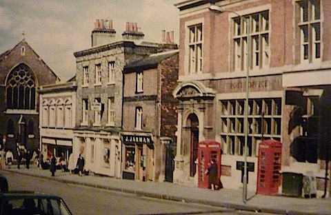
Do you recognise this street view?
On to this week’s and the vintage photo is a Guildford town centre street scene, probably not too hard as some of the buildings remain, or will it prove tricky?
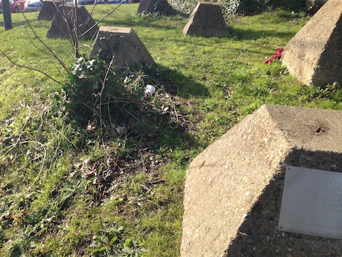
Where can these things be found and what are they?
Reader Raineee Wornham’s son took this week’s quirky photo. What are these strange concrete blocks and where can they be found?
If you think you know the answers, and may be able to add some extra details, please leave a reply in the box below. The answers, along with the next pair of images, will be published about the same time next week.
Share This Post


Responses to Where Is This? No.107
Leave a Comment Please see our comments policy. All comments are moderated and may take time to appear. Full names, or at least initial and surname, must be given.

I'm living well for nothing at all! (See: No Trifling Matter: Magpie Trapped in Godalming Sainsbury’s)


Next stop, Debt Chasm! (See: We Should All Be Outraged About the Failure to Deal with Legacy Debt)


John Lomas
April 30, 2014 at 11:03 pm
North Street Methodist Church at far left of the photo on the corner of Woodbridge Road. I think the first shop, on the corner, was in the 1950s a model and toy shop which might have also sold cycles. Unless the shop I am thinking of is just hidden round the corner.
The large building with the phone boxes is the main post office.
The tank traps, there are a few round the area, but I am guessing near London Road railway station.
Nick Clarke
May 1, 2014 at 12:22 am
I think the second one is the tank defences at the London Road entrance to the London Road railway station.
Christopher Jackson
May 1, 2014 at 7:49 am
Next to London Road railway station bridge and ww2 antitank blocks. #homeguard
John Gibson
May 1, 2014 at 3:17 pm
They be dragon’s-teeth! London Road railway station, anti-tank/vehicle pimples put in around 1940 as part of point defences witin one of the defence lines around the SE of England in case of invasion by the Germans.
Probably would have had iron spikes sticking out the top and linked with barbed wire.
Ron Hilton
May 3, 2014 at 2:16 pm
Two very easy ones this time me thinks.
North Street looking at the post office building, just before it out of shot was the Congregational Church, a very big church at the time. In the distance is the original Methodist Church which was also very big, opposite the church up stairs was Smarts the barber.
Anti-tank traps near railway lines to slow the advance of the German army in WW2 near London Road railway station perhaps.
William O'Brien
May 3, 2014 at 5:15 pm
North Street – Guildford post office – cannot remember the name of the church on the corner?
Tank traps – used to be some on slopes down to the railway – near the university?
Peter Holt
May 5, 2014 at 12:32 pm
1. North Street. 2. Concrete WW2 tank stops. The only ones I know of when I lived in Guildford were by London Road railway station.
Chris Townsend
May 5, 2014 at 6:36 pm
The vintage photo is of North Street, showing buildings little changed since 1894 when the Methodist Church was built on the corner of Woodbridge Road. On the opposite corner was Evans’s wool shop (as I remember it), then Pullen’s florist’s and greengrocer’s, and Jarman’s the tobacconist. To the right is the main post office, demolished in 1971.
The war memorial inside has been removed to the present post office at the top of the street.
The “dragons’ teeth”, WW2 defences partly hidden by undergrowth for many years, are on the embankment near London Road railway station.
Brian Holt
May 5, 2014 at 8:21 pm
The street view is North Street, of the old post office, and you can see the Methodist Church which was on the corner of North Street and Woodbridge Road.
The second photo shows the tank stops (or traps) at the side of the railway bridge in London Road. They are opposite Clandon Road. These anti-tank defences were installed during February 1942 by 578 Army Field Company of the Royal Engineers.
This site is now sponsored by the Safer Guildford Partnership 1998.
Ray Springer
May 6, 2014 at 2:43 pm
This is North Street and the main post office. Next door was Jarmans, the tobacconists and on the corner of Woodbridge Road was Pascalls. Opposite on the other side of Woodbridge Road was the Methodist Church. Apart from the church and the post office, most of the other buildings are still there.
The quirky picture is of the “dragon’s teeth” as they were known, tank traps, erected at the start of Second World War. They are located near Stoke Park, Parkway and the Riverside Nature Reserve.
They would also, no doubt, have prevented the invasion of speed boats!