- Stay Connected

Socialize

 Abraham Lincoln
If given the truth, the people can be depended upon to meet any national crisis...
Abraham Lincoln
If given the truth, the people can be depended upon to meet any national crisis...

 Guildford news...
for Guildford people, brought to you by Guildford reporters - Guildford's own news service
Guildford news...
for Guildford people, brought to you by Guildford reporters - Guildford's own news service
Where Is This? No.108
Published on: 6 May, 2014
Updated on: 6 May, 2014
By David Rose
Many correctly identified North Street featuring the former post office building and the Methodist Church in last week’s vintage photo. Also some interesting notes about others shops and features once in that vicinity.
Even more people identified the ‘dragon’s teeth, anti-tank traps that can be seen near London Road railway station.
These features date from the Second World War are among others than can be found in the area. There are some more in the woods off Parkway near the Spectrum leisure centre.
There is a plaque on one of them at London Road that notes they were put there in 1942 (Brian Holt gives details). That date has puzzled me, as most of these defences (part of what was called the GHQ Stopline) were swiftly constructed and put in place in 1940 when the threat of invasions was thought highly likely.
From my understanding, the concrete blocks had iron ‘loops’ at the top (remains can still be seen). If the enemy had invaded, the blocks would have been lifted, perhaps by some sort of mobile crane or by men using heavy metal poles, into the road.
John Gibson who also replied tells me of another road block in the area which I have not come across before. I will investigate further and once found will offer it up as another mystery image.
Click here to see last week’s reply and all the comments and extra details at the foot of it.
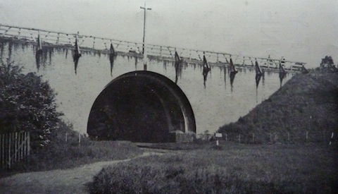
Do you know where this bridge is and why the cross is on it?
On to this week’s mystery vintage image. Here is a bridge a few miles roughly to the south west of Guildford with a wooden cross on it. The photo dates to about 1934 when the road that bridge originally carried was opened. The bridge is still in use but no longer carries the A3, which was diverted when improvements were made some 30-plus years ago. Any ideas where it is and why the cross, which is one of two on the bridge?
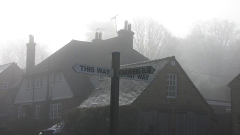
Roads to somewhere, but where can this sign be found?
Here’s the quirky photo and one sent in by Bill Stanniforth. Do you know where the direction sign can be found?
If you think you know the answers, and may be able to add some extra details, please leave a reply in the box below. The answers, along with the next pair of images, will be published about the same time next week.
Share This Post


Responses to Where Is This? No.108
Leave a Comment Please see our comments policy. All comments are moderated and may take time to appear. Full names, or at least initial and surname, must be given.

I'm living well for nothing at all! (See: No Trifling Matter: Magpie Trapped in Godalming Sainsbury’s)


Next stop, Debt Chasm! (See: We Should All Be Outraged About the Failure to Deal with Legacy Debt)


John Lomas
May 7, 2014 at 6:07 am
The bridge over the Pilgrims’ Way near Compton.
This, That and the other Way was at Blackheath near Wonersh (corner of Sampleoak Lane and Blackheath Lane.
John Gibson
May 7, 2014 at 11:56 am
The tunnel/bridge is the A3 slip road southbound that leads to Watts Gallery roundabout at Compton – but no idea why it has a cross on it !
The sign is at the cross roads at Blackheath Village.
Raineee Wornham
May 7, 2014 at 4:08 pm
The bridge is Pilgrims’ Way bridge at Compton.
The crosses are there to mark Pilgrims’ Way, although they are not the original crosses or railings!
The road sign is in Blackheath!
Ray Springer
May 8, 2014 at 11:52 am
This is the bridge carrying the old A3 at Compton, near Down Lane. The road is now a slip road onto the new A3 .
The crosses mark the crossing of the Pilgrims’ Way.
Chris Townsend
May 9, 2014 at 8:06 am
The bridge is at Compton, and carries the original Guildford and Godalming bypass over the Pilgrims’ Way. The bridge and its crosses are visible from the present A3 on leaving Guildford in the direction of Milford.
The quirky sign is near Blackheath village crossroads.
Brian Holt
May 12, 2014 at 3:00 pm
This arch road bridge is for the (B3000). slip road from the A3 into Compton. It was built in 1931 by Edwin Landseer Lutyens, who lived with his parents in nearby Thursley. The two crosses which have been renewed were erected to mark the Pilgrims’ Way.
It can be accessed from Down Lane Compton, by following a footpath westward past G.F.Watts’ house Limnerslease.
The signpost is on the corner of Blackheath Lane and Littleford Lane, at the cross roads in Blackheath.
Chris Kay
May 12, 2014 at 8:31 pm
The bridge is at Monks Hatch near Watts Gallery at Compton.
I think it was designed by Edwin Lutyens. The crosses signify that the Pilgrims’ Way (also North Downs Way) passes below. Monk is a popular designation here, so perhaps there was a monastary
in the area.
The sign is at Blackheath village. If you go on to navigate the heath it can get more confusing!
Doug and Bill Stanniforth
May 14, 2014 at 8:59 am
The first picture is the bridge on the old A3 slip road to Compton. Was the cross something to do with the Pilgims’ Way?
Don’t think it’s a river bridge, so still no chance to use our sparkling new speedboat that we still havhaven’t received yet
Really no idea about the crossroads sign at Blackheath!
Ron Hilton
May 14, 2014 at 4:50 pm
The bridge looks like the old bridge at Compton.