- Stay Connected

Socialize

 Abraham Lincoln
If given the truth, the people can be depended upon to meet any national crisis...
Abraham Lincoln
If given the truth, the people can be depended upon to meet any national crisis...

 Guildford news...
for Guildford people, brought to you by Guildford reporters - Guildford's own news service
Guildford news...
for Guildford people, brought to you by Guildford reporters - Guildford's own news service
Where Is This? No.109
Published on: 14 May, 2014
Updated on: 2 Jul, 2019
By David Rose
There were a number of correct replies saying that last week’s vintage mystery photo showed the bridge near Compton (on the B3000).
I was not aware that it was designed by the famous Edwin Lutyens! The crosses are there as it passes over what is commonly known as the Pilgrims’ Way. Just how many pilgrims passed that way on the supposed route from Winchester to Canterbury we will never know, but probably nowhere near as many as was believed by historians several decades ago.
The sign post, again as many correctly identified, is at Blackheath. Evidently it was erected by a local resident and has stood the test of time for several years now.
See all the replies at the foot of last week’s post by clicking here.
Note that the Stanniforths are still after their speedboat prize (long running joke). Well I guess I will have to pay a visit to the Dolls Hospital in Swan Lane or Pascalls in Woodbridge Road to see if they have any in stock. Anyone got a time machine I can borrow?
Further to the quirky phone a couple of posts ago that featured the Second World War tank traps than can be seen near London Road railway station, my good friend Peter Bullen writes: “I remember the ‘dragon’s teeth’ concrete blocks had a vertical angle iron post sticking out of the tops about four or five feet high. I don’t think they were meant to be moved once in place but were sited in places to prevent vehicles from going off road to avoid other obstacles.
“One such obstacle were lines of big concrete squares fitted flush with the road surface. They did have metal handles sunk into the tops and these were indeed used to pull out these concrete plugs leaving deep, square holes into which huge, heavy metal V-shaped beams were dropped to provide a substantial barrier to any from of transport. I think there was one such barrier in Pewley Way just by the footpath down to Addison Road.
“One unrelated point: do you (or any Dragon readers, perhaps) know of a firm called PHG & Sons, Guildford, who made kitchen furniture under the name Guildform? I have a typical 1950s formica topped kitchen table with an oval white plastic tag underneath with that name on it, but I can find no references to any firm like that in the two or three Guildford directories I have.”
Can anyone add any details?
And now for your perusal this week…
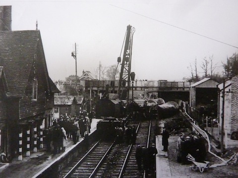
Which railway station near Guildford is this?
The vintage photo features a railway station near Guildford and shows the clearing up operation following a collision of two goods trains in April 1944. One of the trains was made up of fuel tankers that caught alight.
Note the striped posts on the left by the station building painted that way to help passengers when alighting during the blackout. The station is still there (busy east-west line), but the station building has now gone. The steel road bridge might be a clue. Also note the man up the telegraph pole. A small building seen just below him and to the right, still stands.
Can you name the location and are you able to add any more details?
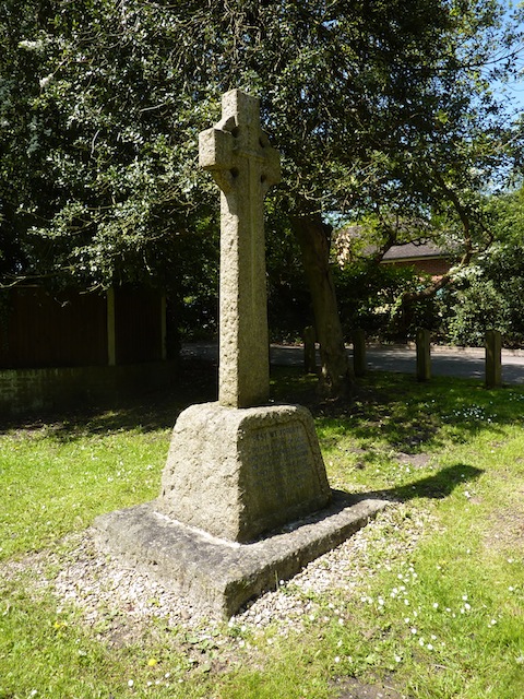
Where is this war memorial?
The quirky photos shows a wayside First World War memorial that is just about on the boundary of one parish in the borough of Guildford and the start of another borough of a now large town.
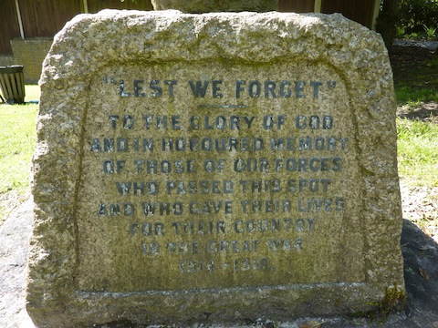
The inscription on the war memorial.
The inscription is interesting in that it does not list any names of fallen servicemen as such, but is a reminder of ‘those of our forces who passed this spot and who gave their lives for their country in the Great War 1914-1918’.
Any idea where it is and perhaps who paid for it?
If you think you know the answers, and may be able to add some extra details, please leave a reply in the box below. The answers, along with the next pair of images, will be published about the same time next week.
Share This Post


Responses to Where Is This? No.109
Leave a Comment Please see our comments policy. All comments are moderated and may take time to appear. Full names, or at least initial and surname, must be given.

I'm living well for nothing at all! (See: No Trifling Matter: Magpie Trapped in Godalming Sainsbury’s)


Next stop, Debt Chasm! (See: We Should All Be Outraged About the Failure to Deal with Legacy Debt)


Dave Holt
May 15, 2014 at 4:44 pm
PHG refers to PH Gillingham & Sons who had a factory where your table was made in Ladymead opposite the fire station. They also had an antique business in London Road near to the ambulance station. I worked there after leaving Northmead school in 1961.
If your table has a white plastic manufacturers label it was made before 1962, about that time they changed to transfers. I remember that we use to stamp the table model number on the frame but not sure about a date.
The factory was managed by the sons Leslie and Percy who sold the factory and site after their father had passed away.
John Lomas
May 15, 2014 at 5:34 pm
The station is Shalford and the timber frame building is now an antiques and florist shop
Ray Springer
May 16, 2014 at 6:04 pm
This is Shalford station. On 11th April 1944 a train of loaded petrol tank wagons collided with another engine at Shalford station. An explosion and fire then ensued and some of the wagons were under the road bridge (A281) The heat caused the steel members of the bridge to buckle.
The driver of the train received the British Empire Medal for moving the burning train to a safe position.
Chris Townsend
May 16, 2014 at 6:13 pm
To answer Peter Bullen’s question about P.H.G. & Sons: could this have been an enterprise of Percival Hugh Gillingham, furniture dealer?
Brian Holt
May 20, 2014 at 12:33 pm
This is Shalford station, the platform on the left used to have several cattle pens.
The memorial is on the junction of Bagshot Road and Berry Lane.
Berry Lane is at Fox Corner, sometimes referred to as being in Worplesdon, but it’s just inside the Pirbright parish boundary.
Doug and Bill Stanniforth
May 20, 2014 at 1:58 pm
First picture is Shalford station. This was extensively used for the transportation of speedboats, albeit model ones to Pascalls. That was the shop opposite the Astor cinema, not the one further down Woodbridge Road that sold motorbikes and scooters including Vespas.
The second picture is the war memorial near Bridley Manor, Berry Lane, Worplesdon.
Chris Townsend
May 20, 2014 at 6:14 pm
The collision was at Shalford Station. All I know on the subject is in a chapter about the incident, with more photos, in the book “Guildford – the War Years 1939-1945”, by Graham Collyer and David Rose. The small building is intriguing; anyone know its history?
The memorial is near the boundary of Worplesdon and Woking, near Fox Corner, opposite the junction of Berry Lane with the Bagshot Road.