- Stay Connected

Socialize

 Abraham Lincoln
If given the truth, the people can be depended upon to meet any national crisis...
Abraham Lincoln
If given the truth, the people can be depended upon to meet any national crisis...

 Guildford news...
for Guildford people, brought to you by Guildford reporters - Guildford's own news service
Guildford news...
for Guildford people, brought to you by Guildford reporters - Guildford's own news service
Where Is This? No.114
Published on: 18 Jun, 2014
Updated on: 20 Jun, 2014
By David Rose
The vintage picture shown last week of a st John Ambulance parade was taken in the sports ground, Woodbridge Road. Markenfield Road can be glimpsed in the background beyond the trees.
The quirky photo featured an aerial view looking towards Jacobs Well, from the water meadows beside Clay Lane.
Click here to see last week’s post and the images.
Three readers emailed their comments, as the reply box systems was, and still is, not working.
Chris Townsend: The vintage photo shows Woodbridge Road sports ground, marked out with running tracks, opposite the garage on the left-hand corner of Markenfield Road. The quirky photo shows Clay Lane, looking towards Jacobs Well. The prominent white building on the right of the bend is Burpham Cottages, the L-shaped building is Jacobs Well Cottage, formerly Jacobs Well Farm, parts of which date from about 1500. To the left is Slyfield industrial estate. The bright blue vehicles are at the Chambers Waste depot.
John Lomas: I reckon the St John picture is Stocton Road and the recreation ground. This would be evening sun, so the parade is facing east. This puts the houses on Stocton Road itself and those arched front doors are typical from number 63 upwards. Unless some of those houses have been demolished then the low building behind the trees is on the site where 57,59,61 are now. I don’t know what was there earlier, but the floodlights at the Guildford City ground might have been visible through that gap. I think that back in the 1950sthe St John base was somewhere in the Leas Road area The aerial picture shows Clay Lane, Jacobs Well, the pool in the garden is very obvious on satellite view (Google). The central vertical axis is around north west and because of the distorting effect of a fisheye or very wide angle lens I suggest the white buildings are on the Slyfield Industrial Estate, probably Alexander Dennis.
Brian Holt: Picture number one is Woodbridge Road sports ground (cricket ground) and the white house used to be offices with the Markenfield petrol station next door on the right. Picture number two is Jacobs Well estate, the road is Clay Lane. On the right of the road is Chamber’s yard. The factories on the left are at the Slyfield Industrial Estate.
And so on to this week’s images…..
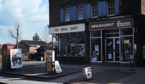
Do you recognise this parade of shops?
The vintage picture dates to about the 1980s, but much has now changed. Neither the wool shop (was also a post office) and the newsagents exist, and what about that cigarette machine! The phone box has gone as well. Do you know were this is?
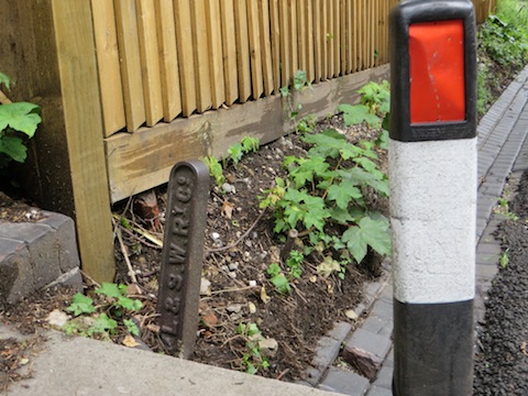
An iron relic from the London & South Western Railway. Do you know where it is?
The quirky photo features a cast iron London & South Western Railway Company (LSWR) marker post. The photo was emailed by Jon Plowman. I had not seen this before. I think it might be a little tricky, but Jon assures me it can be found in a road that’s fairly close to Guildford railway station (the main one).
The ‘Leave a Reply’ comments box is now working again, so if you know the answers please leave a reply in the box below. Comments will be published on Tuesday or Wednesday coming, with the next pair of images.
Share This Post


Responses to Where Is This? No.114
Leave a Comment Please see our comments policy. All comments are moderated and may take time to appear. Full names, or at least initial and surname, must be given.

I'm living well for nothing at all! (See: No Trifling Matter: Magpie Trapped in Godalming Sainsbury’s)


Next stop, Debt Chasm! (See: We Should All Be Outraged About the Failure to Deal with Legacy Debt)


Jennie
June 20, 2014 at 10:55 pm
The first picture is Aldershot Road, on the corner with Southway, good wool shops are hard to find these days.
ray springer
June 22, 2014 at 8:05 pm
This is the corner of Aldershot Road and Southway. Not a lot has changed, the shops are now an undertakers and a flower shop and as you say the phone box has gone.
I have no idea where the quirky picture is – at a guess I would say Walnut Tree Close
Sheila Atkinson
June 23, 2014 at 5:44 pm
The shops are on the corner of Southway Avenue and Aldershot Road. In the early 1950s the wool shop and Post Office were run by a Mr and Mrs Coombs, I went to school with their daughter Rosemary.
Chris Townsend
June 23, 2014 at 5:48 pm
The parade of shops is on the corner of Southway and Aldershot Road. The houses on the left were built alongside what was part of an ancient track which followed old field boundaries out to Farnham Road by Friars Gate, and beyond, past Henley Grove. The track was beside the boundary of the back gardens of Beckingham Road, on lower ground than the Southway road and pavement. There were once sign posts, one at the Aldershot Road end, which from memory said “Footpath to Farnham Road”, and one similar on Farnham Road. Is either of them still there?
Brian Holt
June 24, 2014 at 11:11 am
The parade of shops are in the Aldershot Road. They are my local shops.
The former Aldershot Road post office and wool shop was on the corner of the junction with Southway, and is now Aylings the undertakers.
Forbuoys next door later became Martin Newsagents, then a ladies hairdressers and is now Jean’s the Florist.
Among other shops in the parade is Rowley’s a family butchers shop, Empire Fish and Chip shop & Restaurant, who only fry their fish to order so it is always hot and with very large portion of chips, and Lloyds the Chemist.
In place of the cigarette machine now is the Park Barn & Westborough Community Notice Board, which I regularly update with information,flyers etc.
Brian Holt
June 26, 2014 at 4:46 pm
Yes Norman Hamshere is correct there was a small gents loo there at that end of Southway and is in the picture.
Cannot remember when it closed, probably before the houses was built as no one would want that in front of their houses.