- Stay Connected

Socialize

 Abraham Lincoln
If given the truth, the people can be depended upon to meet any national crisis...
Abraham Lincoln
If given the truth, the people can be depended upon to meet any national crisis...

 Guildford news...
for Guildford people, brought to you by Guildford reporters - Guildford's own news service
Guildford news...
for Guildford people, brought to you by Guildford reporters - Guildford's own news service
Where Is This? No.117
Published on: 9 Jul, 2014
Updated on: 9 Jul, 2014
By David Rose
Not everyone correctly identified Guildford Technical College as featuring in last week’s post. But most correctly named the Three Pigeons pub in the High Street as being in the quirky photo.
Click here to see last week’s post and all the replies with some good additional details about the technical college supplied by Chris Townsend, Ray Springer and Bernard Parke.
Moving swiftly on, here are this week’s mysteries.
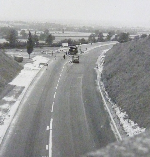
Do you recognise this section of the Guildford and Godalming bypass?
The vintage photo, taken from an over bridge by my friend Peter Turner, shows a section of the Guildford and Godalming bypass when it was made into a dual carriageway at the end of the 1950s / early 1960s. Do you know where this is?
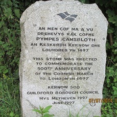
Where can this memorial stone be found?
The quirky photo of a feature that can be seen today was taken by Bernard Parke when out on one of his regular walks.
It’s a memorial stone I had overlooked – Cornish rebels passing through Guildford?
Do you know where it can be found, and can you add any details?
If you know the answers, please leave a reply in the box below. Replies will be published at about the same time next week along with the next pair of images.
Share This Post


Responses to Where Is This? No.117
Leave a Comment Please see our comments policy. All comments are moderated and may take time to appear. Full names, or at least initial and surname, must be given.

I'm living well for nothing at all! (See: No Trifling Matter: Magpie Trapped in Godalming Sainsbury’s)


Next stop, Debt Chasm! (See: We Should All Be Outraged About the Failure to Deal with Legacy Debt)


Chaz Folkes
July 9, 2014 at 12:50 pm
The bridge in the photograph is where the A31 crosses the A3, just at the Guildford end of the Hog’s Back.
The Cornish memorial is on the downs between Wodeland Avenue and Henley Fort, in the corner by the top of the lane.
John Lomas
July 9, 2014 at 10:59 pm
The old photo is surely the A3 passing under the A31 Farnham Road / Hog’s Back.
The Cornow memorial appears to be at Blackheath near Chilworth (courtesy of Wiki). This is a bit of Surrey/Guildford history of which I was totally ignorant and wiki mentions a clash with government forces at “Gill Down”, could that be the downs between Pewley Hill and Newlands Corner, the day after they arrived in Guildford and also that they eventually went from Guildford via Banstead and “Chussex Plain” to the other Blackheath.
This was the area where the final battle, known as the Battle of Blackheath but also called the Battle of Deptford Bridge, took place.
I am looking forward to finding out more from your other correspondents
Margaret Cole
July 10, 2014 at 7:37 pm
The road junction is where the A31 joins the A3 heading towards Guildford taken from the bridge leading to the Hog’s Back.
The Cornish rebels’ stone is probably in Bernard Parke’s garden it’s chalk and no doubt home made!
It has got me fooled, probably The Mount Cemetery. Just a guess.
Lindsay Blackwood
July 11, 2014 at 4:34 pm
Top picture is where the A31 joins the A3.
Memorial stone is at the top right hand side of the Guildford downs just before the exit gate.
Ian Plowman
July 11, 2014 at 9:41 pm
Photo is where the slip road from A31 Hog’s Back joins the A3.
Quirky picture corner of the downs off the green track by Henley Fort
Ray Springer
July 12, 2014 at 6:54 pm
This is the junction of the slip road from the Hog’s Back (A31) on to the Guildford and Godalming bypass (A3).
The quirky picture is of the commemorative stone of the Cornish march from St Keverne in Cornwall to London via Guildford. It is situated on The Mount on the North Downs Way near Henley Fort.
The march in 1497 was in response to an increase in taxes by King Henry VII affecting the tin miners creating the Cornish Rebellion. The stone was placed there in 1997 on the 500th anniversary of the march.
Chris Townsend
July 13, 2014 at 7:40 am
The vintage photo shows where the slip road from the A31 Farnham Road joins the bypass, looking towards the fields of Manor Farm.
Is the bridge over the bypass the one supposed to be afflicted by the legendary Gypsy curse?
The memorial stone is on the Downs near Henley Grove.
Brian Holt
July 13, 2014 at 8:12 pm
(1) This photo was taken from the Farnham Road bridge over the A3, and is looking north towards the cathedral and Guildford.The road on the left is the slip road (A31) from the Hog’s Back.
(2) The memorial stone is at the top of The Mount, on the right 50 yards before Henley Fort, near a gate.
It is a commemorative stone marking the date the county was overrun by as many as 15,000 Cornish rebels heading for London. There was a brief battle just outside Guildford at ‘Gil Down’ in June 1497.
On June 14, 1497, the Cornish army arrived at Guildford, although shocked by the scale of the revolt, Henry VII had not been idle, the army of 80,000 men assembled for Scotland was recalled.
The same day the Cornish army arrived at Guildford, Lord Daubeney and his army took up position upon Hounslow Heath, and were cheered by the arrival of food and wine dispatched by the Lord Mayor of London.
The Crown decided to take the offensive and test the strength and resolve of the Cornish forces. Lord Daubeney sent out a force of 500 mounted spearmen and they clashed with the Cornish at ‘Gil Down’ outside Guildford.
The Cornish army left Guildford and moved via Banstead to Blackheath where they pitched their final camp, looking down from the hill on to the Thames and City of London.
David Bennett
July 14, 2014 at 7:55 pm
I think this is the stretch of the A3 approaching Guildford with the A31 slip road coming in on the left.
Dave Middleton
July 23, 2014 at 6:28 pm
The Road picture is indeed the A3 viewed looking North from the A31 Farnham Road Bridge. What no-one has mentioned yet is the fact that, in those days, to join the A31 Hog’s back from the A3 at that location, you had to turn right at the junction (you can see the bollards and island),and cross the lane for Guildford / London bound traffic. This situation continued on into the early 1980s and I remember it being a real dice with death sometimes to get across, when vehicles came over the brow of the hill at speed where the current slip road is. It was very much a case of “Foot Down and Go For It!” Having made it across, the road up to the Hog’s back (now the slip road down from the Hog’s Back) was two way traffic.
As for the Gypsy Curse Bridge, I understood that was the new slip road bridge to the Hog’s Back, not the Farnham Road bridge. The story I heard was that when the new bridge was being built, some of the workmen were rude to a passing gypsy woman and she cursed them and their work in return for their rudeness, so the curse is much more recent!