- Stay Connected

Socialize

 Abraham Lincoln
If given the truth, the people can be depended upon to meet any national crisis...
Abraham Lincoln
If given the truth, the people can be depended upon to meet any national crisis...

 Guildford news...
for Guildford people, brought to you by Guildford reporters - Guildford's own news service
Guildford news...
for Guildford people, brought to you by Guildford reporters - Guildford's own news service
Where Is This? No.120
Published on: 29 Jul, 2014
Updated on: 29 Jul, 2014
By David Rose
Great replies once again to last week’s images.
The vintage photo showed a ‘slow’ train to Portsmouth between the two tunnels at St Catherine’s. The bridge from where the picture was taken is Ferry Lane. Plenty of railway facts offered by those who replied.
Frank Phillipson emailed his reply with an image of the former British Railways crest. Here it is:
“The photo shows a 4-SUB (4 coach suburban) EMU (Electrical Multiple Unit) built in 1940s by the Southern Railway heading south between the two tunnels at St Catherine’s.
British Railways crest featuring a lion, a wheel and a crown.
“It is one of the earlier units with a domed cab roof. The date is the late 1960s even 1970/71 as the unit has full yellow warning ends but the coach livery appears to be Southern Region green as half way along the leading coach there seems to be the circular British Railways “ferret and dartboard” crest (actually a lion holding a wheel) which was used with this livery.
“If it were the later all blue livery you would expect to see the white double arrow British Rail logo on the side near the cab door.
“The “73” headcode is for a Waterloo to Portsmouth & Southsea, slow, via Worplesdon. Were 4-SUBs used often on this sort of service south of Guildford? I thought that they were mainly used on the New Guildford line via Effingham Junction to terminate at Guildford in Platform 1.”
The quirky photo of a fading ‘ghost sign’ can be seen in Chapel Street. Again some excellent extra details, but as two bakers are mentioned – Gwinn’s and West’s, I’m not sure which one was the one that had the HOVIS sign on its wall. I think Brian Holt has explained who was where in Chapel Street.
Click here to see the replies and additional details at the foot of last week’s post.
Here are this week’s mysteries.
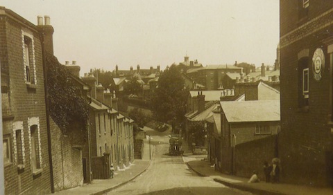
Do you recognise this street?
The vintage photo show a street in a ‘hilly’ part of Guildford. In the distance an institution can be seen, a little of which has been preserved. That’s a good clue!
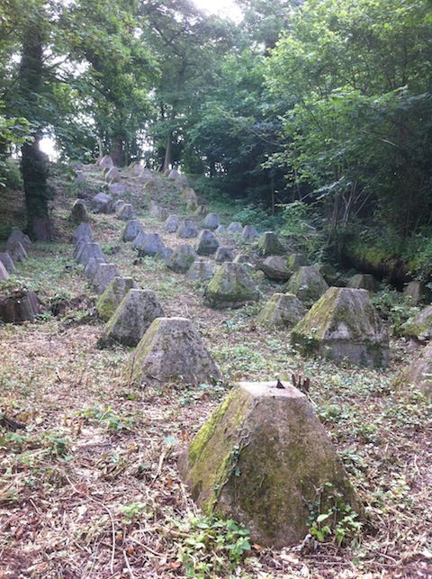
Have you seen these features from Britain’s Second World War defences?
We have featured the anti-tank traps near London Road railway station before, but here are some more in Guildford that have fairly recently had the undergrowth that had been partially covering them removed. As a clue, they are in some woodland near a River Wey backwater.
If you know the answers, please leave a reply in the box below. Replies will be published at about the same time next week along with the next pair of images.
Share This Post


Responses to Where Is This? No.120
Leave a Comment Please see our comments policy. All comments are moderated and may take time to appear. Full names, or at least initial and surname, must be given.

I'm living well for nothing at all! (See: No Trifling Matter: Magpie Trapped in Godalming Sainsbury’s)


Next stop, Debt Chasm! (See: We Should All Be Outraged About the Failure to Deal with Legacy Debt)


Chaz Folkes
July 30, 2014 at 12:10 pm
The vintage shot is taken from the top of Cooper Road in Charlotteville looking across to St Luke’s Hospital. There are a few of the old buildings worked into the new development as well as the old Spike building on Warren Road. I recall a butchers on the right hand side of Cooper Road which I think shut at the end of the 90s.
The second set of tank traps go down to the River Wey between the Spectrum and the bridge under the A3. I saw a yard-long grass snake sunning itself nearby when I last walked down that way and haven’t been back since!
Dave Middleton
July 30, 2014 at 9:16 pm
The street scene is Cooper Road at Charlotteville, looking east from the junction with Addison Road. The junction on the right is Cline Road, where the Pig and Tater pub, latterly the Foresters was located, sadly recently converted into houses and flats I believe.
The “institution” would’ve been St Luke’s Hospital on Warren Road, also now gone and the site given over to housing, apart from The Spike which has been preserved. The large building on the right in the foreground was a shop of some kind and still remains, albeit as flats.
Shirley and Brian West
July 30, 2014 at 10:06 pm
I think it is Cooper Road. Cline Road and Addison Road are on the right. Looking down, on the corner of Cline Road was the Pig and Tater public house.
Chris Townsend
August 3, 2014 at 1:03 pm
The vintage photo is dominated by the grim prospect of the workhouse on the horizon. The view shows Cooper Road, with the corner of the former post office on Addison Road on the right. Looking down the road, on the left-hand corner of Cline Road was a shop, and on the right the Foresters Inn, now redeveloped. In the centre is the climb up to Warren Road beside the boundary wall of the workhouse site.
Brian Holt
August 4, 2014 at 9:08 pm
This picture is of Cooper Road taken from the junction with Addison Road. The first building on the right is the side of the Addison Road Post Office and shop.
These tank traps are behind the Spectrum running track, towards the river.
Doug and Bill Stanniforth
August 5, 2014 at 5:18 pm
It’s Cooper Road, home of the Pig and Tater.
The other photo is probably near St Catherine’s (like a lot of photos seem to be).
Yes, I find it’s easy to get to St Catherine’s on my speed boat – but, in this case, are totally wrong. Ed
Margaret Cole
August 6, 2014 at 3:17 pm
The first picture is Cooper Road, Charlotteville, on the corner of Addison Road. The plaque is on the side of the grocer’s shop, C Deneyerno, 12 Addison Road, and the distant view is of St Luke’s Hospital.
The second picture is at London Road station. They are known as dragons teeth and are tank traps erected 1941 as a deterrent.