- Stay Connected

Socialize

 Abraham Lincoln
If given the truth, the people can be depended upon to meet any national crisis...
Abraham Lincoln
If given the truth, the people can be depended upon to meet any national crisis...

 Guildford news...
for Guildford people, brought to you by Guildford reporters - Guildford's own news service
Guildford news...
for Guildford people, brought to you by Guildford reporters - Guildford's own news service
Where Is This? No.121
Published on: 6 Aug, 2014
Updated on: 6 Aug, 2014
By David Rose
A view looking down Cooper Road was the mystery vintage view last week. Correctly identified by a number of readers.
Click here to see their replies at the foot of last week’s post.
Being that the picture postcard view was probably taken around 1910, the institution on the horizon was then in full operation as the Guildford Union Workhouse, that had been built in 1836.
“After 1930, the workhouse became a Public Assistance Institution under the name St Luke’s Home. The workhouse infirmary was taken over by Surrey County Council in 1930 and became Warren Road Hospital. In 1945, it became St Luke’s Hospital, and in 1948 became part of the newly created National Health Service.”
The above paragraph can be read on a fantastic website devoted to workshouses. Click here to go to the section on Guildford’s workhouse – well worth reading and some very good images!
The anti-tank traps, also known as dragon’s teeth (no relation to this news website) featured in the quirky image last week can be found in the woodland near the Spectrum leisure centre, just off Parkway, and bordering a backwater of the River Wey. It’s actually the ‘original’ river as the cut of the Wey Navigation bypasses it from Stoke Mill to Bowers Lock.
I liked Chaz Folkes’ comment about seeing a very big snake there a while ago!
So, what’s the name of that woodland? It was once part of the grounds of Stoke Park Mansion, so I guess it is a part of today’s Stoke Park.
My parents always called it the Riverside Walk. But in the 1970s a school friend always referred it to Dingley Dell. I thought he called it that as Dingley Dell was also the title of Geordie folk-rock band Lindisfarne’s third album. We were both avid fans of the band. But just recently, while talking to a bottle collector friend of mine on one of our ‘bottle digs’, the woodland cropped up in conversation and he called it Dingley Dell. Does anyone have any thoughts?
The path through the woods leads to a field that borders today’s Stoke Nature Reserve. While walking it with my dad when I was quite young we encountered a swarm of bees. Just as scary as Chaz’s snake!
And now on to this week’s mysteries…
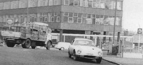
Do you recognise this view?
The vintage photo is a bit grainy I have to admit, and I have cropped it somewhat from the top. The direction the sports car is going in can’t be attempted these days! Some clues there for you. Do you recognise this view?
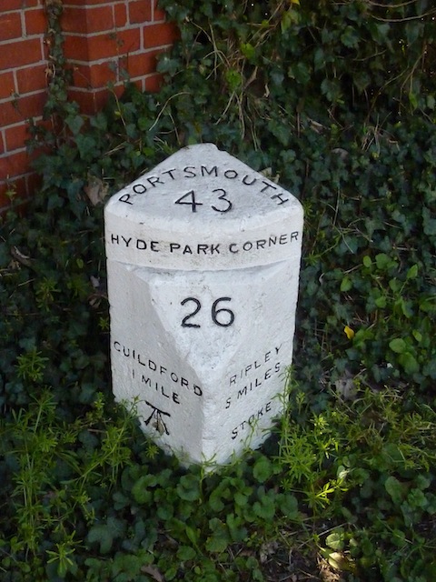
Do you know where this can be found?
The quirky photo is one one of Guildford’s mileposts. Where can this one be found? If you don’t know exactly, the mileage distances shown may help you to work it out.
Does anyone know how hold these are?
If you know the answers, please leave a reply in the box below. Replies will be published at about the same time next week.
Share This Post


Responses to Where Is This? No.121
Leave a Comment Please see our comments policy. All comments are moderated and may take time to appear. Full names, or at least initial and surname, must be given.

I'm living well for nothing at all! (See: No Trifling Matter: Magpie Trapped in Godalming Sainsbury’s)


Next stop, Debt Chasm! (See: We Should All Be Outraged About the Failure to Deal with Legacy Debt)


John Lomas
August 7, 2014 at 8:43 am
The mile post is on the town-side exit from roundabout at the junction of Boxgrove Road and Parkway with London Road.
It would appear that Surrey and Hampshire have stretched over the years as the Ripley and Portsmouth distances are too short. :-D.
Incidently, is that an OS benchmark on the MS under the Guildford distance?
I would have thought that to be a vulnerable place to put an OS height marker, surely it is liable to be moved by a vehicular strike.
John Lomas
August 7, 2014 at 8:58 am
I think the lorry is turning left from the bottom of Farnham Road towards either the railway station and Walnut Tree Close, or by bearing right passing the garage, Bridge Street. The Lotus is heading towards the Farnham Road bus station one-way system.
Dennis Harvey-Hepherd
August 7, 2014 at 10:42 am
This picture is of the Bridge House site at the corner of Walnut Tree Close and Bridge Street on what is now the Guildford gyratory system.
Mark Lenel
August 7, 2014 at 11:11 am
The black & white photo is (I think) on the Guildford gyratory, looking over what is now East Bridge House.
The milepost is at the roundabout at the top corner of Stoke Park, on the corner of London Road and Boxgrove Road.
Chaz Folkes
August 7, 2014 at 11:56 am
The milestone is by roundabout where London Road, Parkway and Boxgrove Road all join up.
The building in the older photograph looks a bit like Friary Court that covers the A281, but the Shell station signs don’t fit in with that theory…
Mo Legg
August 7, 2014 at 2:31 pm
Surely this must be the first modern building on the current Bridge House site at the junction of Bridge Street and Walnut Tree Close.
I remember as a lad the maze of red painted steel sections being put together by the brave/foolish erectors.
Sorry haven’t a clue of the whereabouts of the milepost, but does anyone know where in Guildford town centre is the datum point for milepost measurements?
David Seymour
August 8, 2014 at 7:30 am
This building was opposite the train station as you enter Walnut Tree Close from the one way system. I think possibly that the building was occupied by Shell.
Les Knight
August 8, 2014 at 9:04 am
Bridge House, Walnut Tree Close.
Norman Hamshere
August 8, 2014 at 1:08 pm
Would have been site of the Railway Hotel where Railway Esplanade joined Bridge Street and Walnut Tree Close. The sports car would be heading the wrong way round the infamous gyratory system.
Chris Townsend
August 10, 2014 at 3:55 pm
The vintage photo shows the original Bridge House, built about 1961. The opposite corner, to the right, now occupied by the YMCA and an underpass, was the site of the Railway Hotel until it was demolished in 1963.
The milestone is on London Road, just west of the junction with Boxgrove Road. To help date the stone: from 1748 to 1873 the road was owned by the Kingston upon- Thames to Sheet Bridge [near Petersfield] Turnpike Company; from 1767, milestones were compulsory on turnpike roads to help coaches keep to schedule.
The 1871 town plan has MS (for milestone) marked on the north side of Spital Street (Upper High Street), near the site of the present-day Pizza Express. I don’t find it marked on later maps, so maybe the stone has been lost during road widening, but I have spotted the next one, down the Portsmouth Road.
Errol Newman
August 10, 2014 at 4:21 pm
The building is/was Bridge House that contained Guildford 2 Tax Office. It was opposite the entrance to the railway station on the corner of Walnut Tree Close. I was lucky to have a school holiday job there.
I think the milestone is near Fanum House, the AA office, at the end of London Road, corner of Boxgrove. It has an Ordnance Survey bench mark, used by surveyors to ascertain the local ground heights, etc. above sea level (Ordnance Datum). Now no longer needed with modern satellites.
Mike Dillon
August 10, 2014 at 7:06 pm
Bridge House Bridge Street
Brian Holt
August 12, 2014 at 12:31 pm
Bridge House was on the corner of Walnut Tree Close and Bridge Street. Built in the early 1960’s it was initially used by the Post Office as it area telephone headquarters. You went there when you wanted a telephone installed. The Shell filling station underneath was operated by Coombs who had garages in Portsmouth Road, and on the by-pass going towards the Hog’s Back.
When the new Bridge House was built it was a government office for the South East.