- Stay Connected

Socialize

 Abraham Lincoln
If given the truth, the people can be depended upon to meet any national crisis...
Abraham Lincoln
If given the truth, the people can be depended upon to meet any national crisis...

 Guildford news...
for Guildford people, brought to you by Guildford reporters - Guildford's own news service
Guildford news...
for Guildford people, brought to you by Guildford reporters - Guildford's own news service
Where Is This? No.122
Published on: 11 Aug, 2014
Updated on: 11 Aug, 2014
By David Rose
A good many replies to last week’s mysteries – the vintage photo showing the junction of Farnham Road and Bridge Street near the entrance to the railway station and Walnut Tree Close and the original Bridge House. While the quirky photo showed a milepost that can be found near the roundabout on the corner of London Road and Boxgrove Road, beyond the top end of Stoke Park.
Click here to see last week’s post and all the replies – plenty of comments about the vintage picture and the milepost (including how old it might be). How many of us still call it the AA roundabout? The AA’s Fanum House hasn’t been occupied by the motoring organisation for years!

Do you recognise this view?
Moving swiftly on to this week’s, and a vintage photo sent in by John Lomas and dating from the 1970s. However, there has been quite a bit of change by this part of the River Wey over the past 40 years. Do you recognise the scene?
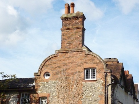
Do you know where this building is?
The quirky photo shows the end of a rather pleasing building not far from Guildford town centre. Do you know where it can be found and perhaps add some extra details?
If you know the answers, please leave a reply in the box below. Replies will be published at about the same time next week.
Share This Post


Responses to Where Is This? No.122
Leave a Comment Please see our comments policy. All comments are moderated and may take time to appear. Full names, or at least initial and surname, must be given.

I'm living well for nothing at all! (See: No Trifling Matter: Magpie Trapped in Godalming Sainsbury’s)


Next stop, Debt Chasm! (See: We Should All Be Outraged About the Failure to Deal with Legacy Debt)


John Gibson
August 12, 2014 at 11:15 am
First photo is of the River Wey, looking downstream at Woodbridge Meadows, probably taken from footbridge crossing river looking through arch of “7 arches” railway bridge.
To the left is sorting office before it was surrounded by present day security fencing. To the right these buildings are part of the new Fairview Home flats and Travis Perkins site. The outfall into river in centre of picture still exists but the towpath is now surfaced and there is a small car park where the people are sitting.
The building is the gable end of No.20 Quarry Street but I don’t know much more about it than that.
Doug and Bill Staniforth
August 12, 2014 at 4:49 pm
The photo of the river is Walnut Tree Close with the sorting office on the left and on the right it shows Keith Moon’s Timber Yard.
The building is probably near St Catherine’s.
The photo by the Wey was taken years ago just before I passed through in a new speed boat. Just thought you would like to know. Ed
Mike Melbourne
August 23, 2014 at 1:56 pm
Who? John Moon I believe.
David Middleton
August 12, 2014 at 6:05 pm
The gable end of the building is on Number 20 Quarry Street at Guildford, not a million miles from the Guildford Museum!
The river view is the Wey at Woodbridge Meadows, near to the current Royal Mail sorting office, The old Travis Perkins wood yard is on the right of the picture. I suspect the picture was taken from the wooden pedestrian footbridge, looking under the railway viaduct.
Chaz Folkes
August 13, 2014 at 9:16 am
The river scene photograph is of Woodbridge Meadows. The trees have grown a bit since then!
The second photograph is taken on Quarry Street just past the Castle Arch. It’s the last building on the west side of the street going towards the A281.
Margaret Cole
August 13, 2014 at 8:18 pm
View of the River Wey that shows the Guildford sorting offices, Woodbridge Meadows on the left and Dennis’ Works high in the background. On the right is where Wickes store now is.
No.13 Quarry Street just opposite the Castle Arch. This grade 2 listed building was once Lloyds Bank regional office.
In 1988 builders found ancient murals beneath the plaster, which were carefully framed and restored (see the book Changing Face of Guildford).
The house is now on the market for a princely sum. Keep buying the lottery tickets.
Chris Townsend
August 16, 2014 at 8:13 am
The 1970s photo looks as if it was taken from a bridge. I think Emmanuel Church and Stoughton Barracks are on the horizon. On the right could be a builder’s yard, as was once on Woodbridge Road, with the back of the old Co-op Dairy on the left. So my guess is that the view is from Woodbridge, looking north.
The quirky photo shows 20 Quarry Street, a listed building which dates from the 16th century with later additions. Why is it named The Fountain Head? Was it once a pub?
ray springer
August 17, 2014 at 7:02 pm
Think this is the river adjacent to Walnut Tree Close in Woodbridge Meadows
Ray Springer
August 18, 2014 at 10:16 am
The quirky picture is a building in Quarry Street (number 19 I think) currently occupied by Architects Gerry Lytle.
Brian Holt
August 18, 2014 at 10:04 pm
This photo taken from the footbridge next to the railway bridge in Woodbridge Meadows.
On the right of the River Wey is Travis Perkins timber yard and store. On the left is the old Royal Mail sorting office, next door is now Screwfix.
Doug and Bill Stanniforth
August 19, 2014 at 12:00 pm
The building is nowhere near St Catherine’s but is 20 Quarry Street which commands a view of Leroy’s (Speed) Boat Yard.
Yes, and views of speedboats are all you lucky lads are going to get. Ed
Norman Hamshere
August 19, 2014 at 5:12 pm
Picnickers in the shadow of the railway viaduct at Woodbridge Meadows
John Lomas
August 20, 2014 at 12:03 am
The Dutch gable is the first house, on the left, as you come up the hill on Quarry St from the junction with Millbrook.