- Stay Connected

Socialize

 Abraham Lincoln
If given the truth, the people can be depended upon to meet any national crisis...
Abraham Lincoln
If given the truth, the people can be depended upon to meet any national crisis...

 Guildford news...
for Guildford people, brought to you by Guildford reporters - Guildford's own news service
Guildford news...
for Guildford people, brought to you by Guildford reporters - Guildford's own news service
Where Is This? No.124
Published on: 27 Aug, 2014
Updated on: 27 Aug, 2014
By David Rose
Memories were certainly stirred by last week’s mystery photos.
Click here to see last week’s post and all the replies with those details at the foot of it.
Starting with the vintage photo of White’s Stores in Worplesdon Road, some good information about the other businesses and people that ran them on that stretch of road.
My old mate Simon Vine mentioned a copy of a newspaper from September 1, 1939, that he found in one of the derelict houses there back in the 1970s. I don’t think I was there that day. I am sure I would have tried to grab it from him and would still have it!
Once or twice some of our gang climbed the fence over the railway line beyond Pinks Hill at Wood Street and entered an old trackside permanent way hut. There we found pages from old newspapers stuffed between the timbers, probably an attempt by the railwaymen to stop the draughts. I didn’t get to keep them. Malcolm (the Dragon’s regular birdwatcher correspondent) might have had them.
On to the quirky photo that showed the building in Haydon Place that was once Andertons music story, and a very interesting reply from Heather Earl, who notes that the building was constructed in 1930 for The Haydon Furnishing Works, owned by her grandfather Harold Challen, and his partner.
Heather also adds that the firm had previously used the premises more latterly known as the Berverley Hall for the Deaf, and until recently was occupied by the Guildford School of Acting.
The hall is not going to be demolished and a few months ago I was contacted by Cllr Caroline Reeves enquiring about its history. I couldn’t help her much, but evidently the hall is going to be renamed and a suitable one at that is being sought. I suggested something simple like Haydon Hall.
The thing is, no one seems to know why the name ‘Beverley”. Can anyone help with that?
Here are this week’s mysteries…
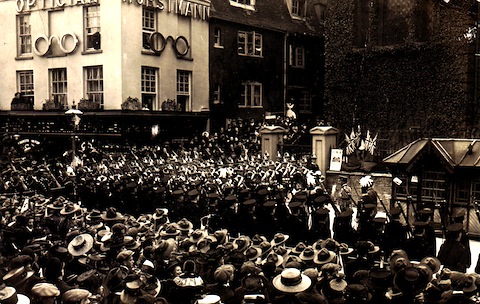
A crowd has gathered to mark an occasion. Where and what?
A large crowd has gathered in Guildford town centre. I think it might date to the peace celebrations in 1919 to mark the end of the First World War. Do you recognise the location and can you add any details about the event or other features shown?
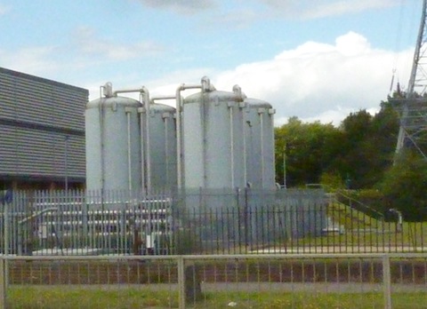
Where are these and what are they used for?
The quirky picture shows some storage tanks beside a busy stretch of road in Guildford. Have you seen these and does anyone know what they are for? I haven’t a clue.
If you know the answers, please leave a reply in the box below. Replies will be published at about the same time next week.
Share This Post


Responses to Where Is This? No.124
Leave a Comment Please see our comments policy. All comments are moderated and may take time to appear. Full names, or at least initial and surname, must be given.

I'm living well for nothing at all! (See: No Trifling Matter: Magpie Trapped in Godalming Sainsbury’s)


Next stop, Debt Chasm! (See: We Should All Be Outraged About the Failure to Deal with Legacy Debt)


Heather Earl
August 27, 2014 at 10:45 pm
This is not relating to this week’s photos – but I can answer your query about the earlier uses of the Beverley Hall. I have a newspaper cutting about it (from Surrey Ad. – unknown date but must be early fifties as it states the closure of the Haydon Furniture Works).
The article mentions that it was first used as a chapel of the Primitive Methodist Church, from 1878. When this use was discontinued, at an unknown date, it was used as a tobacco and cigar factory for several years by “Mason & Toogood” until 1919, when it was acquired by Harold Challen’s Furnishing business.
I think the name Beverley Hall came about after the closure of that business, but have no idea of the reason for it.
John Lomas
August 27, 2014 at 11:53 pm
The old photo looks like it could be High Street looking from Abbot’s Hospital side towards Holy Trinity Church. The shelter is reminiscent of the cabbies’ shelters seen in London.
The event could be, a thanksgiving service post WWI, before the memorial was erected in the Castle grounds, a St George’s Day parade (see the St George’s flags), or possibly a royal celebration coronation/jubilee etc.
Holy Trinity was the pro-cathedral from 1927 on until consecration of the permanent cathedral on Stag Hill.
The modern picture is on Ladymead between the Next building and Allianz. It appears that the site may be some sort of electricity substation judging by the overhead lines and pylons finish there.
I wonder if the hold coolants, maybe liquid or gas, of some sort. Is that a windsock (visible on Google street view) for helicopter landings on the site or perhaps to warn of wind direction if there is a leak of gas?
On the other hand, it is the site, and apparently the same building, next to the tanks of the old Guildford Corporation’s waterworks pumping station.
David Jopson
August 29, 2014 at 7:10 pm
Where is this No:124 is Guildford High Steet Outside Holy Trinity Church. The taxi drivers’ ‘cabin’disappeared sometime in the 1960s
Chris Townsend
August 30, 2014 at 12:51 pm
I don’t know why “Beverley”, but the former chapel is marked on an 1896 O.S. map, with the street to the west then known as North Place. Surrey History Centre’s catalogue lists an 1874 item: “Primitive Methodist Church, Guildford: invitation to a Bazaar to be held in the Eastern Hall (where was that?) in Guildford to raise funds for the new chapel and schools then being built in North Place, Stoke Fields.”
To confuse things, in Lyn Clark’s book on Stoke, she mentions that Francis Paynter “built the Haydon Place Hall to be used as an educational centre for teetotal ideas”. Is that a different hall – but where?
If there’s a foundation stone for the hall, behind the present hoardings, maybe it has the answers.
Ray Springer
August 30, 2014 at 8:20 pm
This has to be one of the celebrations at the end of WW1 when The Queen’s (Royal West Surrey) Regiment paraded outside the Holy Trinity Church in the High Street. The Horstmann’s the Opticians building is still in existence but presently now occupied by Mint Velvet, a ladies fashion shop.
The quirky photo is in Ladymead. Thames Water owns this property, and I guess the vessels must contain water or chemicals. Originally this site was the Guildford, Godalming & District Water Board and the building designated a pumping station.
Chris Townsend
August 31, 2014 at 6:51 pm
The vintage photo shows the top of High Street outside Holy Trinity church. The late C18th building on the left remained an optician’s (Bateman’s) until recently.
From Matthew Alexander’s “Vintage Guildford”, I read that Frederick Horstmann set up as a clockmaker, jeweller and antique dealer in Upper High Street in 1899; he was the first qualified optician in the town. The firm moved to the building in the photo in 1909.
The cabmen’s shelter on the right survived for many years, at least into the late ’50s.
Doug and Bill
September 2, 2014 at 4:39 pm
It’s Holy Trinity Church, High Street.
The tanks are next to the Environment Agency building on Ladymead, possibly containing extra water needed when speed-boating.
Of course those with no boats – need no water! Ed
Margaret Cole
September 2, 2014 at 9:02 pm
Holy Trinity Church proclaiming something special, military, Scouts and dignitaries all there, a bit before my time – so its one to you.
There tanks are next to NEXT and Halfords on the left, the other way is Ladymead Pumping Station, so probably to do with purification of the Water but who knows?