- Stay Connected

Socialize

 Abraham Lincoln
If given the truth, the people can be depended upon to meet any national crisis...
Abraham Lincoln
If given the truth, the people can be depended upon to meet any national crisis...

 Guildford news...
for Guildford people, brought to you by Guildford reporters - Guildford's own news service
Guildford news...
for Guildford people, brought to you by Guildford reporters - Guildford's own news service
Where Is This? No.72
Published on: 27 Aug, 2013
Updated on: 27 Aug, 2013
By David Rose
Some divided opinions as to the North Street church shown here last week. It was, in fact, the Congregational Church, on the corner of Lea Pale Road, not the Methodist Church, that was on the corner with Woodbridge Road.
And the train can indeed be seen at the entrance to the small car park in Woodbridge Meadows near the ‘seven arches’ railway bridge. It is a model of an M7 class locomotive. Thanks to Mr Holt (the Clitherow Kid) and Norman Hamshere who recognised the tank engine and added some detail.
To see all the replies at the foot of last week’s post, with lots of additional information about the Congregational Church, click here. Do read John Lomas’ comment regarding the panda crossing that can be seen in last week’s vintage photo too.
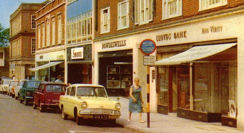
Does this street scene look familiar?
On to this week, and staying with a traffic theme, here’s a cropped view from a colour picture postcard dating to about the 1960s. May not be too difficult for our regular experts to recognise, but it’s obviously from the days before yellow lines were painted here and you didn’t need to buy a ticket to park either!
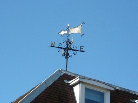
Do you recognise where this weather vane is?
This week’s quirky ‘thing’ is a weather vane that can be found quite near the town centre – do you know where?
If you know the answers to this week’s, and perhaps have some comments to make, please leave a reply in the box below. All replies will be posted at about the same time next week, along with a new post with the answers to this week’s vintage photo and quirky picture, and the next pair of images.
Share This Post


Responses to Where Is This? No.72
Leave a Comment Please see our comments policy. All comments are moderated and may take time to appear. Full names, or at least initial and surname, must be given.

I'm living well for nothing at all! (See: No Trifling Matter: Magpie Trapped in Godalming Sainsbury’s)


Next stop, Debt Chasm! (See: We Should All Be Outraged About the Failure to Deal with Legacy Debt)


Bernard Parke
August 28, 2013 at 6:24 am
Upper High Street on the opposite side to RGS.
Once known as Spital Street as there was once a hospital in this part of Guildford.
The building at the end is that of the Old Guildford Borough Council Office.
Norman Hamshere
August 28, 2013 at 10:24 am
Upper High Street, Lloyds bank sub branch,A nn Verity hair dresser, Guildford Municipal Offices far left and a selection of cars now only seen on the rally field including an Austin Farina A40 – our first car.
Peter Bullen
August 28, 2013 at 10:25 am
Outside Eastgate Buildings in Upper High Street with the old Municipal Offices, last building on the right. And, yes,those were the days when you could park right outside the shops even in the High Street itself, for nothing! Although there was keen competition for places, particularly on a Saturday morning.
ray springer
August 28, 2013 at 12:05 pm
I have got the last two (70 & 71) wrong, but I think I am right this time – it is Upper High Street from the Municipal Offices to Ann Verity, including Dowdswells, Lloyds Bank, Smarts and Charles Holden (Grocers). Don’t think any of them are there now.
Still searching for the weather vane
Carol Norris
August 28, 2013 at 12:13 pm
Picture 1 : Upper High Street with turning to Eastgate Gardens just visible at the left side of the photo. Good view of the well-known local family Dowdeswells’ stationery shop. I seem to recall another of their shops at some time in Swan Lane and then a move to bigger premises at the Ladymead end of Walnut Tree Close.
John Lomas
August 28, 2013 at 8:30 pm
Upper High Street, near the entrance to Eastgate Gardens and the car park.
A little further up the road (behind the camera and on the same side was the library), in my time it was in a temporary building which I believe had previously been a Civic Restaurant.
Judy Oliver
August 29, 2013 at 10:23 pm
The postcard shows the upper High Street where McDonalds is now. The square building on the far left is the old Municipal Buildings where the council used to be housed before moving to Millmead.
Sue Bushell
August 31, 2013 at 6:53 pm
This is the Upper High Street where McDonalds is now situated.
Chris Townsend
September 1, 2013 at 5:19 pm
The postcard shows the north side of Upper High Street at the top of the town. On the left is a glimpse of the ’60s block which replaced shops east of Allen House. Then there’s the Municipal Offices, built in the early ’30s, demolished in the ’80s, and the entrance to a car park and Eastgate Gardens. Next to the two shops on the corner is Smart’s, house furnishers, then Eastgate House. Dowdeswell’s were printers and stationers and sold office equipment. Ann Verity was a ladies’ hairdresser’s.
The weather vane is on the building on the corner of Tunsgate and Sydenham Road.
Brian Holt
September 1, 2013 at 6:00 pm
The shops are in the upper High Street by the entrance into Eastgate Gardens.
The weather vane is above the shop of Bardoe & Appel and the offices, on the corner of Tunsgate and Sydenham Road.
Do not know what the date is for, unless it’s the date the building was built.
Peter Holt
September 2, 2013 at 10:15 am
This week’s photo was taken at the top of the High Street. The building on the far left is the old council office.
The weather vane is on top of an office block in Tunsgate / Sydenham Road.
See page 52 of “Guildford Through Time”. Another good book from David Rose and Bernard Parke.