- Stay Connected

Socialize

 Abraham Lincoln
If given the truth, the people can be depended upon to meet any national crisis...
Abraham Lincoln
If given the truth, the people can be depended upon to meet any national crisis...

 Guildford news...
for Guildford people, brought to you by Guildford reporters - Guildford's own news service
Guildford news...
for Guildford people, brought to you by Guildford reporters - Guildford's own news service
Where Is This? No. 73
Published on: 3 Sep, 2013
Updated on: 4 Sep, 2013
By David Rose
Well done to one and all who correctly recognised last week’s vintage photo as being in Guildford’s upper High Street and the weather vane being on a building on the corner of Tunsgate and Sydenham Road.
Click here to see last week’s post and all the replies with lots of information about what was in view.
John Lomas mentioned the restaurant that was once in the upper High Street. This was one of Guildford’s wartime British Restaurants, set up nationally to provide a decent meal for people at a modest cost. There is more about them in my book Guildford The War Years 1939-45 (co-written with Graham Collyer).
One thing I am keen to find out about is the fact that in some British Restaurants tokens were issued for meals. People could buy these in advance and then use them to pay for their meals. It meant that at busy times the service was sped up so that transactions by way of issuing change in real money was not needed.
I am always on the look out for any of these tokens that people may have tucked away somewhere. We know they were used in the Godalming area. Godalming Museum has a few in its collection.
Also, I was interested to read Norman Hamshere’s comment about the Austin Farina A40 pictured in the upper High Street and that it was his family’s ‘first car’.
This is now taking me back, but I remember that car well. (Wasn’t it light blue in colour?) Norman might just recall, but in about 1969, I travelled in that car with with my dad along with Norman (driving) his wife Joy and their first daughter Sue, down to the Longmoor Military Railway near Liss.
I believe, at the time the Merchant Navy class Bullied pacific, 350028 ‘Clan Line’ was in shed there, and from time to time the recently preserved loco was in steam.
I remember, as a nine-year-old, being in the back of the car – Joy must have had Sue on her lap, and that was before their second daughter Julie was born.
As we passed across the county boundary from Surrey into Hampshire (and seeing a sign beside the road) me saying “now we have three Hamsheres in Hampshire!” Funny the things that stay in the old brain box after all these years!
Anyway, enough of my railway ramblings, but only to add that of course ‘Clan Line’ is still regularly seen to this today hauling railway steam specials through Surrey.
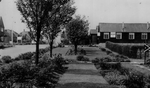
Which army camp is this? The photo dates to about the 1960s.
On to this week’s mystery vintage photo and a view of an army camp somewhere in Guildford. Even if you don’t know the exact spot where the photo was taken, I’m hoping many readers will be able to name the camp and add a few details.
I am not sure of the exact location – the houses on the left my be a give away. I think they are still there and the site of the camp is now full of houses. What can you add?
Do you know where this is?
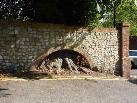
The ‘quirky’ thing is an interesting picture of a wall, quite near Guildford town centre. Whoever built this wall came up with a neat solution to get around the roots of a large tree. As a clue, it is near a house with a strong literary connection and opposite a well known place that contains a wealth of local history.
If you know the answers to this week’s, and perhaps have some comments to make, please leave a reply in the box below. All replies will be posted at about the same time next week, along with a new post with the answers to this week’s vintage photo and quirky picture, and the next pair of images.
Share This Post


Responses to Where Is This? No. 73
Leave a Comment Please see our comments policy. All comments are moderated and may take time to appear. Full names, or at least initial and surname, must be given.

I'm living well for nothing at all! (See: No Trifling Matter: Magpie Trapped in Godalming Sainsbury’s)


Next stop, Debt Chasm! (See: We Should All Be Outraged About the Failure to Deal with Legacy Debt)


Deanna Avery
September 4, 2013 at 12:41 am
The wall with the tree trunk roots is on the bottom of Guildford castle, next to Guildford museum.
Peter Bullen
September 4, 2013 at 10:31 am
The WRAC camp, Stoughton? And the tree root is opposite the entrance to the Castle Grounds in Castle Arch.
ray springer
September 4, 2013 at 12:11 pm
The barracks must be the Queen Elizabeth WRAC barracks in Grange Road, not sure whereabouts though.
The “quirky” picture of a wall is in Castle Hill nearby to “The Chestnuts” house where Lewis Carroll lived and died (1898) He is buried in The Mount cemetery in Guildford.
Opposite is the Guildford Museum
Chris Townsend
September 6, 2013 at 7:30 am
The view is of the WRAC camp which was at the end of Grange Road, Stoughton, and is now the Queen Elizabeth Park estate. The house and bungalows on the left are in Tylehost, opposite what is now Princess Mary Close, where there was once an entrance to the camp. Present-day street names have associations with the WRAC.
The quirky wall is opposite the entrance to the Castle Grounds nearest Castle Arch, off Quarry Street
Bernard Parke
September 6, 2013 at 5:57 pm
1) WRAC camp at Stoughton. I seem to remember that there was a second entry point off Harts Gardens.
2) Tree opposite the museum building near Castle Arch
Andrew Cox
September 7, 2013 at 9:25 am
The second picture is at the bottom of Castle Hill next to the Castle Grounds.
Brian Holt
September 8, 2013 at 6:12 pm
As the photo shows a road with a slope rising then dropping down in the distance this is Tylehost at the bottom of Johnston Walk.
The Barracks on the right was the Womens Royal Army Corps, Queen Elizabeth Park. there was a gate here.
As there is no perimeter wall or any fencing
are these huts part of the Barracks.
The wall built around the roots of a tree are opposite the bottom Castle Grounds gate that comes out into Castle Hill (or at the back of Guildford Museum).
david & ann bailey
September 9, 2013 at 3:35 pm
We think the WRAC camp at Grange Road Stoughton
Castle Hill close to The Chestnuts.
doug and bill
September 10, 2013 at 9:27 am
we think this is Grange Road. Very near shere the cafe was near ‘pig alley’. not far from Briitens Pond where a speedboat can be used (hint).
The tree root is near Castle Arch by Lewis Carroll’s house and the castle (not far from the river (another hint).
doug and bill
September 10, 2013 at 9:32 am
is this Grange Road near the old cafe by pig alley, not far from Brittens Pond where a speedboat can be used (HINT).
The tree root is near Castle Arch and near Lewis Carroll’s house, the castle and river (ANOTHER HINT).