- Stay Connected

Socialize

 Abraham Lincoln
If given the truth, the people can be depended upon to meet any national crisis...
Abraham Lincoln
If given the truth, the people can be depended upon to meet any national crisis...

 Guildford news...
for Guildford people, brought to you by Guildford reporters - Guildford's own news service
Guildford news...
for Guildford people, brought to you by Guildford reporters - Guildford's own news service
Where Is This? No.78
Published on: 8 Oct, 2013
Updated on: 8 Oct, 2013
By David Rose
The Bridge Cafe once stood in Ladymead, opposite the junction with Woodbridge Road. Today it’s roughly where the car park of B&Q is. And of course many correctly identified this view as seen in last week’s mystery vintage photo.
The crown, as also pictured last week, can be seen in Guildford High Street where the NatWest bank is. It was where the Crown Inn once stood. See last week’s post and all the replies at the foot of it – as always some excellent additional information.
I might be wrong, but adding to Brian Holt’s comments about Haydon’s bank, I think that has become Lloyds TSB bank – that is a little further down the High Street. I’m going on what Matthew Alexander noted in his book Vintage Guildford, published in 1981.
Brian also mentioned pub landlord Mr Curtis, also known as ‘Robin Redbreast’, due to the red waistcoat he always wore. The Curtis family once owned the farm that occupied the land beyond the Bridge Cafe and over towards the river.
But wasn’t Robin Redbreast also the landlord of the Vintner’s Arms pub that was in North Street – halfway between Swan Lane and what’s now the entrance to M&S?
In the early 1960s, Bert Curtis (either son or grandson of Robin Redbreast, I think) played drums in a Guildford band that went by the name of the Age Beaters.
Do click on to the link Bill Staniforth has added in his comment that will take you to a Flickr page of 1968 flood photos. I have not seen any of those particular pictures before!
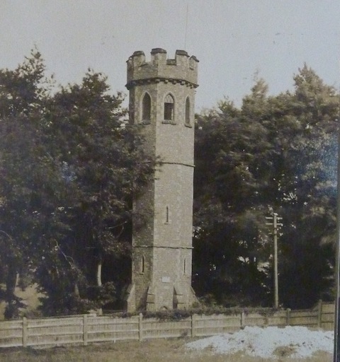
Where is this tower?
Here’s this week’s mystery vintage photo. I’m not sure how many of you will recognise this 1921 view of a stone tower. It still stands, much hidden by trees and next to one of Guildford’s cemeteries. Do you know the name of it and where it can be found?
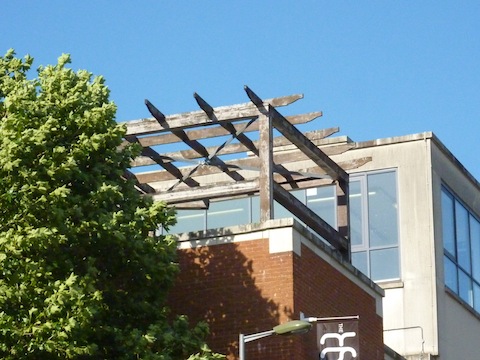
Where can this be found?
Seen above is this week’s ‘quirky’ photo of something in the town centre. Any ideas?
If you know the answers to this week’s, and perhaps have some comments to make, please leave a reply in the box below. All replies will be posted at about the same time next week, along with a new post with the answers to this week’s vintage photo and quirky picture, and the next pair of images.
Share This Post


Responses to Where Is This? No.78
Leave a Comment Please see our comments policy. All comments are moderated and may take time to appear. Full names, or at least initial and surname, must be given.

I'm living well for nothing at all! (See: No Trifling Matter: Magpie Trapped in Godalming Sainsbury’s)


Next stop, Debt Chasm! (See: We Should All Be Outraged About the Failure to Deal with Legacy Debt)


Ray Springer
October 9, 2013 at 8:56 am
The tower is Bookers Tower behind the Mount Cemetery.
It was built in the 1830s and named after the then Mayor of Guildford, Charles Booker.
Bernard Parke
October 9, 2013 at 11:51 am
1) Bookers Tower The Mount Cemetary
2) Roof Garden of The Kings Head in Quarry Street/Castle Street
John Lomas
October 9, 2013 at 5:08 pm
Hi
Good job you gave the clue about a cemetery.
I lived in guildford and surrounding districts from birth to 24 and had not evem heard of this.
http://en.wikipedia.org/wiki/Booker's_Tower
Is the other picture Harvey’s roof garden?
Is it still in use, I remember having coffee up there and watching the tipping buckets water feature over the pool.
Ian Plowman
October 9, 2013 at 8:48 pm
The tower is Bookers Folley at the Beech Lane end of the Old Mount Cemetery. The photographer was stood in the new cemetery.
Andy C
October 11, 2013 at 9:07 am
The tower is in the cemetery just off The Mount. No idea what it is called though!
The odd structure is part of the Thai Terrace isn’t it? I did wonder if it was the top part of Printing House Square, but the wood in the photo doesn’t look half as bad 😉
David & Ann Bailey
October 11, 2013 at 2:40 pm
This is Bookers Tower, next to The Mount Cemetary, built by the father of two boys who drowned in the River Wey.
This stucture is on the top of The Garden Resturant next to the multistory car park in Sydenham Road.
Chris Townsend
October 11, 2013 at 5:59 pm
Booker’s Tower is in the far corner of the old section of the Mount Cemetery, but has lost its crenellations. Charles Booker, three times Mayor of Guildford, built the Tower in 1839 as a memorial, and to perpetuate his name. He had two sons, who both died aged 15: Charles Collyer in 1824, and Henry in 1827. The white heap is probably chalk, the result of grave-digging, on the new cemetery side of the path.
The quirky photo shows the top corner of Milkhouse Gate and Sydenham Road. The wooden structure is above the Thai Terrace restaurant whose sign is just visible.
Doug and Bill Staniforth
October 15, 2013 at 5:08 pm
The tower is at the edge of The Mount cemetery. Interestingly, you can see the River Wey from the top of it. An absolute Mecca for speedboats.
Just a wild guess, the other picture is the Thai Terrace in Sydenham Road.
[Hmmm, unusually perceptive. Anyone might think you have been getting help. Anyway, as all responsible boatmen know there is a 5 knot speed limit on the river. Clearly, in the unlikely scenario that you were eligible for a speed-boat prize, it would have to be issued with paddles, and no engine, to prevent local law-breaking. Ed]