- Stay Connected

Socialize

 Abraham Lincoln
If given the truth, the people can be depended upon to meet any national crisis...
Abraham Lincoln
If given the truth, the people can be depended upon to meet any national crisis...

 Guildford news...
for Guildford people, brought to you by Guildford reporters - Guildford's own news service
Guildford news...
for Guildford people, brought to you by Guildford reporters - Guildford's own news service
Where Is This? No.87
Published on: 11 Dec, 2013
Updated on: 11 Dec, 2013
By David Rose
North Street was the location of last week’s mystery vintage photo, with the quirky photo being the Baptist chapel in Chertsey Street.
Some good answers by those who left replies. Thank you. To read their comments, with a lot more details about North Street and the chapel in Chertsey Street that was once a place of Methodist worship, click here for last week’s post and all those replies at the foot of it. Chris Townsend supplies a link about the history and origins of that Baptist chapel.
Replying to Gay Wheeler’s comment about a blacksmith being on the site where the library is now in North Street. I can’t say for certain I have heard that. I do know that for many years the site was occupied by tent and marquee firm Alfred Bull. Can anyone add any details?
For some more details about the origin of Quakers’ Acre in North Street. There is one of the town centre history plaques at its entrance. Part of the wording reads: “Quakers Acre The Society of Friends, or ‘Quakers’ as they were generally known, became established in Guildford during the 1650s, when Oliver Cromwell ruled following the Civil Wars. They suffered persecution after the Restoration of Charles II in 1660 but in 1672 this was relaxed. The Guildford Quakers, who had previously met in each other’s homes, now felt it time to acquire a Meeting House and burial ground. In 1673 they acquired a house and a plot of land at the North Street end of the inn-yard of the Crown (now the NatWest Bank). A new meeting house was built on a site across the street in 1805 and this garden was used simply as a cemetery until it was given to the town in 1927.”
Now on to this week’s mystery pictures. Here’s the vintage one…
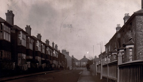
Do you recognise this street?
Here’s a street scene from just before the First World War. It’s in Stoughton. Towards the end of the line of houses on the left are some shops. There are still shops there, well of a kind! No traffic back then, nothing like that at all now! Any idea which road?
Using Google Street View or similar websites are allowed, but you may not qualify for that speedboat prize!
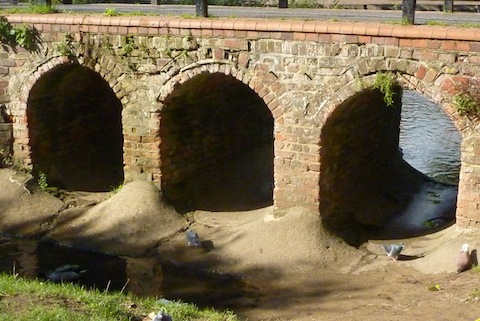
Do you know where this bridge can be found?
The quirky photo taken a few weeks ago features some a nice brick arches that form a small bridge. Do you know where this is?
If you know the answers to this week’s, and perhaps have some comments to make, please leave a reply in the box below. All replies will be posted at about the same time next week, along with a new post with the answers to this week’s vintage photo and quirky picture, and the next pair of images.
Share This Post


Responses to Where Is This? No.87
Leave a Comment Please see our comments policy. All comments are moderated and may take time to appear. Full names, or at least initial and surname, must be given.

I'm living well for nothing at all! (See: No Trifling Matter: Magpie Trapped in Godalming Sainsbury’s)


Next stop, Debt Chasm! (See: We Should All Be Outraged About the Failure to Deal with Legacy Debt)


Bernard Parke
December 11, 2013 at 12:15 pm
1) Manor Road
2) The bridge leading to GBC at Millmead
John Lomas
December 11, 2013 at 5:04 pm
Hi
That is the top of Manor Road, just before the bend, looking uphill.
The houses in the far distance with a single chimney stack are actually the backs of the houses on New Cross Road which look out at the front on to the recreation ground where the Carols in the Park event is held.
Vanessa Sewell
December 11, 2013 at 6:14 pm
I’m thinking Manor Road, the shops being the tattooists? The second one is definately the footbridge leading across from the council offices to Millmead Lock.
ray springer
December 11, 2013 at 6:41 pm
The road is Manor Road looking towards the junction with Stoughton Road and Grange Road.
The bridge is the one over the river beyond Millmead on the pedestrian link from the Council Offices to the Yvonne Arnaud Theatre and Millbrook.
This is not an ideal spot for speed boats, I might add.
Gina Redpath
December 12, 2013 at 10:24 am
This is the bridge over the river between the canal and Millmead behind the Yvonne Arnaud Theatre.
Now 27 and living in Beijing, Betty [daughter?] was just 7, it had been raining for many days and these arches were almost completely submerged, we were on the bank by the furthest arch watching the fast flowing water when she stepped forward, slipped and was completely submerged, we managed to haul her out losing just one Wellington Boot. It was a very wet and memorable walk home.
P Holt aka Cliterow Kid
December 12, 2013 at 12:01 pm
This weeks photo was taken at the top end of Manor Road. I think you can see my brother walking down the road. The bridge can be seen from Millbank car park.
If I am right please can you e-mail me some more cigars before Christmas. Thank you.
We don’t wish to encorage ‘kids’ to smoke so thanks but no cigars. Ed
Chaz Folkes
December 12, 2013 at 3:24 pm
The bridge is on Millmead island, just down from the Council Offices on the path that leads to the Yvonne Arnaud.
Carol Norris
December 12, 2013 at 6:37 pm
Photo 2 : Foot bridge from Millmead going towards YAT. I remember walking easily across the river when the water was very low – I think sometime in the 1950s. The picture looks as if it was taken at that time.
Judy Oliver
December 13, 2013 at 12:09 am
The first picture I think is Manor Road, at the top with the awkward bend.
The arches are down at Millmead
Brian Holt
December 15, 2013 at 10:14 pm
This is looking up Manor Road towards Stoughton Road.
On the left at the end of the houses were four shops. The first one was B A Dawson Stores and next door was Mr Clark’s tailoring.
Mr Joe Dawson (a well known YBS bus driver) came with his parents and sister to Manor Road Stores in November 1928. These two shops became Zodiac Cleaners and is now a tattoo shop.
Joe’s father did not enjoy very good health, but he did what he could in the shop, and worked a lot of ground in the allotments in Stoughton Road (now Badger Close). He sold the produce at the shop.
Joe used to go round the streets of Stoughton, Westborough and Rydes Hill district with a horse and cart. Calling on customers, selling fruit, vegetables and dry goods, Tuesdays to Saturdays. On Mondays he went round with paraffin, brushes, pots and pans, soap and soap powder.
The horse and cart was kept in a shed and stable, which years later become the wool shop in Manor Road then a pet shop. However, in 1933 the horse and cart were disposed of and a van was acquired.
Mr Dawson died at the end of 1933 and Joe and his mother carried on until May 1936, when the business was sold.
The arches are under the bridge across the river going from Millmead towards the theatre.
Great comment Brian, thank you. You paint a lovely picture of Guildford in the inter-war years and the different pace of life that existed then. Ed
Chris Townsend
December 16, 2013 at 7:53 pm
The Stoughton scene shows the top of Manor Road looking towards the bend in the road and the backs of the houses on New Cross Road, at the junction with Stoughton Road and Grange Road.
In the quirky photo those are townie pigeons, so the arches are those of the footbridge over the river by Millmead, where the path leads towards the lock and Millbrook.
Doug and Bill
December 17, 2013 at 3:51 pm
It’s Manor Road, behind the fence on the left is Guildford’s famous tattoo parlour (specialising in nautical tattoos)
The bridge is at Millmead near the Council Offices probably where they keep their emergency speedboat(s)
Bernard Parke
December 18, 2013 at 7:23 am
1) Abbot’s Hospital with a Dennis coach
2) The weir opposite the Guildford Rowing Club