- Stay Connected

Socialize

 Abraham Lincoln
If given the truth, the people can be depended upon to meet any national crisis...
Abraham Lincoln
If given the truth, the people can be depended upon to meet any national crisis...

 Guildford news...
for Guildford people, brought to you by Guildford reporters - Guildford's own news service
Guildford news...
for Guildford people, brought to you by Guildford reporters - Guildford's own news service
Ash’s New Road Bridge: GBC Answers Some Of The Key Questions
Published on: 12 Dec, 2023
Updated on: 14 Dec, 2023
 By David Reading
So long as all goes to plan, in just under a year Ash will have a new road bridge crossing the railway line near Ash Station. Guildford Borough Council’s aim is to alleviate the traffic problems that build up at the station when the level crossing barrier goes down.
Over the years, we have published the concerns that some people have expressed about the project, as well as giving the planners’ reasons for going ahead. The concerns centre primarily on the cost of the project, and on doubts about whether the bridge will genuinely address Ash’s traffic problems effectively.
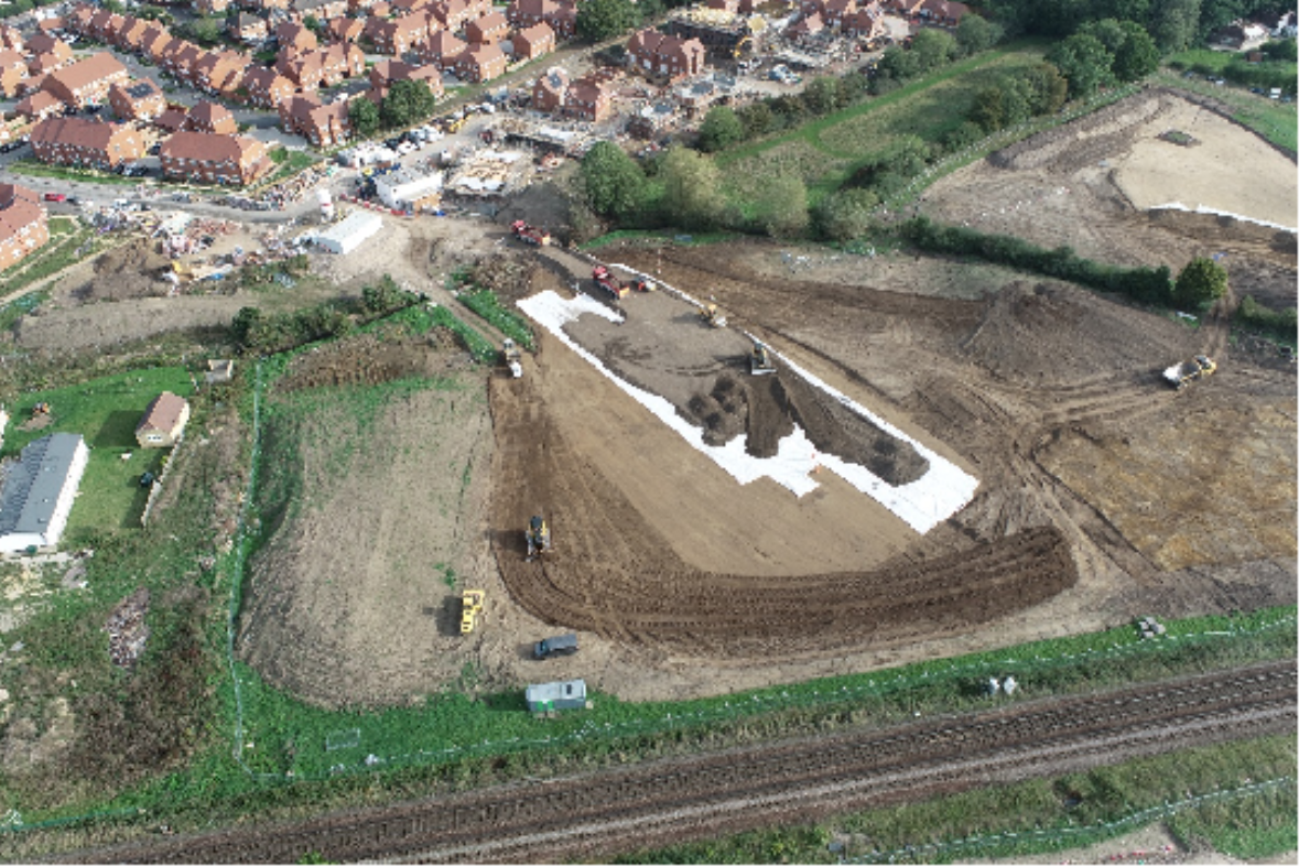
Ash bridge: north embankment fill begins
In this article, we asked the council a series of questions that address some of the concerns.
We have reported that completion of the work is expected in December 2024. Are you still on course to meet that target, and will be bridge actually open at that time?
GBC: We made excellent progress when the weather was good in September. Storms Babet and Ciaran hampered our progress slightly and we now expect the work to finish in January 2025. But the bridge will open before then, as it forms part of Phase Five of the traffic management scheme in October 2024. Traffic will be diverted over the bridge rather than down Ash Church Road and over the level crossing. The level crossing will be closed to vehicles, but open for pedestrians.
You can find details of the traffic management scheme on our website. Traffic management updates for Ash Road Bridge – Guildford Borough Council
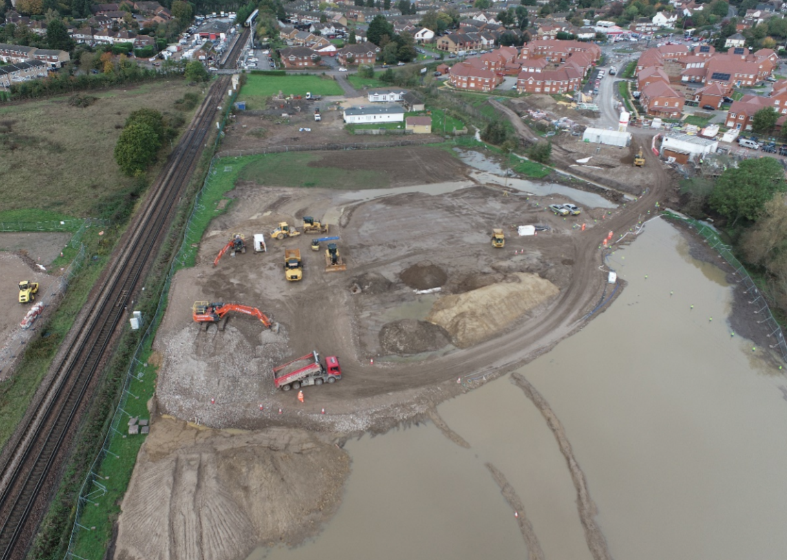
Flooding following Storm Ciaran – north side
Do you have a clear idea when work will start on the footbridge, and when it is likely to open?
GBC: At present, Network Rail is undertaking the feasibility study for the footbridge over the railway at Ash Station. They will then prepare detailed design documents. We will submit a planning application when the feasibility report and detailed design information are received. The actual work on constructing the footbridge will be Network Rail’s responsibility.
Some people have expressed concerns that while the traffic problems around the level crossing will be alleviated, the bridge project will simply move the problems to other areas. Could you address this concern?
GBC: Baseline traffic monitoring has taken place this year and will be repeated in 2024. The focus of the monitoring is Grange Road. We will also complete further monitoring to establish the current use of key local routes.
Before the bridge is open, a report will be submitted to Guildford Borough Council as the Local Planning Authority. Surrey County Council will then be consulted as the Local Highway Authority. It will include details of the survey results, timings, and locations of traffic surveys that will take place after the bridge has opened. The report will cover the possible needs for further traffic calming requirements at Grange Road or Foreman Road.
The later surveys are likely to take place 12 months after the opening of the bridge to allow for traffic patterns to settle. If traffic is shown to have increased on Grange Road beyond an agreed threshold, then additional measures will be considered.
The surveys and reporting will focus on whether there has been any change in the use of Grange Road after the bridge has opened. Additional traffic data will also be captured for links such as the A323, Foreman Road and Ash Green Road to review any difference in the use of these routes following the opening of bridge and closure of the level crossing to motor vehicles.
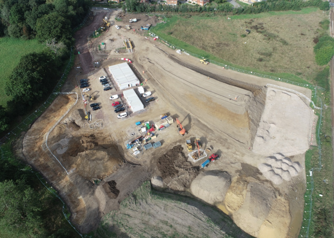
South side ramp under construction.
We have reported the total cost of the project as £45 million. Could you provide a breakdown on who is contributing what?
GBC: The total updated budget is £44 million.
- We have secured £23.9 million towards the road bridge from the Homes England Housing Infrastructure Fund (HIF).
- Surrey County Council is contributing £5million.
- Section 106 contributions have been secured by the council from developers building housing in the vicinity of the level crossing, and these will continue to be secured. At this stage we can’t confirm details of the S106 contributions.
- The rest will come from a combination of council reserves and borrowing.
What measures are being taken to alleviate any flood risk that may result from the bridge project?
GBC: There will be two attenuation basins and one buried attenuation tank. These are designed to temporarily store storm water, to then be released back into the watercourse. The surface water run-off from the new highway goes into these.
They have been sized to provide enough storage for a ‘design storm of one in 100 years’. This means an extreme storm that will be equalled or exceeded, on average, once every 100 years, or has a one per cent chance of occurring in any given year. They also include an extra 40 per cent allowance for climate change.
The two basins also have an extra 30cm depth before an overflow level is reached to provide more volume.
The basins and tank are designed to be dry to maximise the available storage volume. They will fill up during a storm and then dissipate the surface water runoff into the watercourse at a controlled rate until they are empty.
In addition to the basins and tank to control surface water runoff from the highway, there are three flood compensation storage areas north of the railway: two larger ones to the east of the new road and a smaller area to the west. These have been sized to accommodate the volume of floodwater displaced by the development from the floodplain. Again, these will be typically dry, except in flood conditions. The two larger flood compensation storage areas are profiled towards the watercourse with flap valves to allow the water to drain back into the watercourse when levels subside.
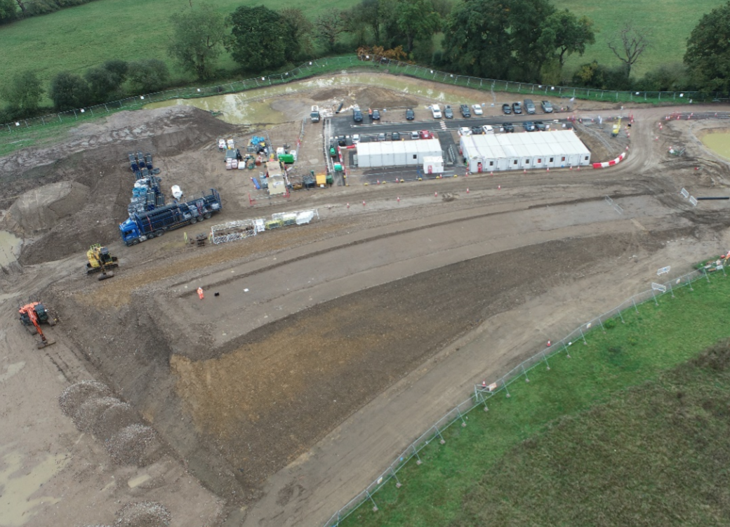
Embankment and site offices on the south side
What work will be undertaken to enhance the environment around the bridge?
GBC: The landscape design aims to integrate the bridge into the surroundings by planting native species of trees and mixed native woodland plants. Species-rich grass meadow and native species hedgerows will be used along the highway to create a physical buffer and visual screening. Wet grassland meadow species will also be planted within flood attenuation ponds and flood compensation basins.
Species-rich grass meadow has more than 15 plant species per square metre and more than 30 per cent cover of wildflowers or sedges.
In addition, three bat boxes and three bird boxes will be erected in trees to the north-east of the bridge. Six dead log piles will be created on the embankment slopes to the north of the railway. These will provide habitat for invertebrates, reptiles/amphibians and hedgehogs. Further details can be found in Planning Condition 27 on the GBC Planning Portal.
Share This Post


Responses to Ash’s New Road Bridge: GBC Answers Some Of The Key Questions
Leave a Comment Please see our comments policy. All comments are moderated and may take time to appear. Full names, or at least initial and surname, must be given.

I'm living well for nothing at all! (See: No Trifling Matter: Magpie Trapped in Godalming Sainsbury’s)


Next stop, Debt Chasm! (See: We Should All Be Outraged About the Failure to Deal with Legacy Debt)


Richard Lucas
December 12, 2023 at 3:11 pm
Good reporting.
Pertinent, relevant questions.
Straight answers with sufficient detail
Lisa Wright
December 12, 2023 at 8:22 pm
The traffic lights at the Dovers roundabout have been a nightmare for months, sometimes adding 20 minutes a time to a trip to Ash and Tongham.
I drove through the area yesterday and noticed work progressing through the new housing estate ( I wonder if they knew there was going to be a new main road through that estate before buying their houses)
However, since the workmen have now moved to the other side of the train crossing, they’ve blocked off Foreman Road with fencing and cones. Unfortunately the kids coming out of school were walking along the inside of the road where the traffic cones have been placed where the pavement used to be. It was getting dark and was very dangerous…an accident waiting to happen. Yes, they could have walked on the other pavement side but they’re kids so won’t do that. Who do we contact to let them know of the dangerous situation for pedestrians?
Frank Emery
December 14, 2023 at 2:46 pm
As a matter of interest to many locals, what is going to happen to the current pedestrian and cyclist situation?
George Potter
December 15, 2023 at 1:57 pm
I think this is answered in the article: “Traffic will be diverted over the bridge rather than down Ash Church Road and over the level crossing. The level crossing will be closed to vehicles, but open for pedestrians.”
George Potter is a Lib Dem borough councillor for Burpham