- Stay Connected

Socialize

 Abraham Lincoln
If given the truth, the people can be depended upon to meet any national crisis...
Abraham Lincoln
If given the truth, the people can be depended upon to meet any national crisis...

 Guildford news...
for Guildford people, brought to you by Guildford reporters - Guildford's own news service
Guildford news...
for Guildford people, brought to you by Guildford reporters - Guildford's own news service
Concerned Burpham Residents Submit Development Plan To Guildford Borough Council
Published on: 1 Nov, 2014
Updated on: 2 Nov, 2014
Burpham residents concerned over future development in their area have submitted their plans to Guildford Borough Council.
The plan, drawn up by the Burpham Neighbourhood Forum, contains a suite of policies that seek to guide development in Burpham over the next 20 years.
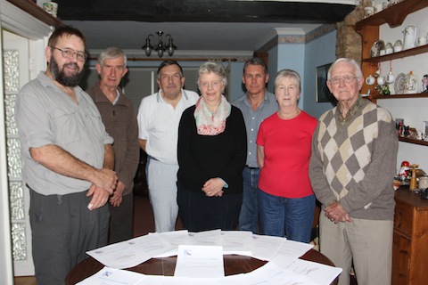
Members of the Burpham Neighbourhood Forum who have submitted their neighbourhood plan to Guildford Borough Council.
The policies cover a range of topics, such as protection of the environment and general development control issues, such as the density of new development and parking requirements.
It seeks to designate important green spaces in Burpham as ‘local green space’, giving such land a high level of protection from future development, in accordance with Government policy set out in the National Planning Policy Framework (NPPF).
 The chairman of the Burpham Neighbourhood Forum, Ros Pollock, said: “The plan has been submitted to the council for the final round of consultation before submission to an independent examiner.
“The plan represents over two years hard work by forum members, who are passionate about their community and who want to ensure future development in Burpham is appropriate and of a high standard.
“Input into the plan by local people has been extensive and, subject to a local referendum, I look forward to the plan becoming part of the development plan for Burpham and therefore a material consideration in the determination of planning applications in the ward.”
The plan can be viewed on the forum’s website at: Burphamneighbourhoodforum.org
Neighbourhood planning is a flagship government policy, designed to empower local communities. Burpham was the first community in Guildford to designate a forum and prepare a neighbourhood plan.
Guildford Borough Council will now check the plan for legal compliance, before launching a six-week public consultation period.
Following the consultation the council must appoint an examiner to review the plan. The examiner must be a suitably qualified person whose appointment is made with the agreement of the forum. The examiner can: recommend the plan progresses to a referendum of voters in Burpham; recommend the plan be amended before referendum; or recommend the plan not proceed to a referendum.
A simple majority is required in the referendum for the plan to become part of the development plan for Burpham.
In the meantime, the Secretary of State can recover planning appeals relating to 10 or more housing units in Burpham to determine himself.
Share This Post


Responses to Concerned Burpham Residents Submit Development Plan To Guildford Borough Council
Leave a Comment Please see our comments policy. All comments are moderated and may take time to appear. Full names, or at least initial and surname, must be given.

I'm living well for nothing at all! (See: No Trifling Matter: Magpie Trapped in Godalming Sainsbury’s)


Next stop, Debt Chasm! (See: We Should All Be Outraged About the Failure to Deal with Legacy Debt)


Peter Knight
November 2, 2014 at 8:26 pm
Where are the generations who are likely to be affected in 20 years in this picture?
I’ve also just looked at their website a typical question reads: “Do you believe that the Slyfield Link Road will be a Rat Run?”
Pretty embarrassing really – many leading questions designed to influence and deliberately designed to make interviewees think in a certain way.
Challenging a link road which will see so many residents benefit by reduced traffic on their roads and diverting that traffic straight onto the A3 is the most logical thing I’ve heard from the council. But I guess not in my back yard Burpham eh?
Put your efforts in to voting in a decent councillor this time!
Jim Allen
November 3, 2014 at 12:46 am
Clearly Mr Knight lives in a truly Utopian world – The age of the people in the picture has absolutely no relevance at all to the plan’s contents.
Please read the survey responses, they are on the Burpham Neighbourhood Forum website – and we jumped through that diversification / age hoop two years ago.
Then instead of saying “congratulations on a magnificant effort”, Mr Knight has to bring in a side subject and moan about that. I would guess he lives on the other side of the Wey and believes: “direct the traffic out of my back yard into someone else’s’, without consideration to the existing and future traffic problems of Burpham.
I believe his approach is a biased and unsustainable stance to take. Perhaps he would like to consider the proposed 2,000 houses at Gosden Hill, and the 1,000 at Merrow, which will generate close on 5,000 additional cars on to Burpham roads when Aldi is taken into account.
As he has raised the question of the illogical link road, perhaps he should consider a few known facts before bringing in a second subject to a simple good news press release.
1: It will be a longer (approximately half a mile) noiser route to the A3 as the route will raise HGV’s 20 feet above the surrounding green belt when it crosses the Wey and A3.
2” The route will directly affect 135 properties which will not be eligible under current schemes for noise mitigation compensation.
3: The route is to be built over drying flats (dried sewage) onto the deepest section of a zone 3b active flood on to Clay Lane which is all green belt, on a route restricted by a 7.5-ton weight limit.
4: There is no documentary or statistical evidence for need.
5: The route will require extensive pedestrian protection for primary school children crossing Clay lane due to the additional HGV traffic predicted.
5: The cure for the A320 Moorfield intersection can be achieved via use of section 16 of the Commons Act. The removal of the bus lane on the A320 which is used 30 seconds every 16 minutes would also go a long way to remove the traffic problem. While it should be noted that the highest accident rate along the A320 is between Jacobs Well Road and Clay Lane, this proposed new link road will do nothing to solve that problem.
Far better, solve the A320 problems (costing £1’000s) and then do the traffic survey to discover need from Slyfield (costing millions).
6: The incidental claim is this link road will make no difference to the A320 traffic, but they want to bring in another 400 jobs with associated traffic. 300 HGV movements per day, which is also illogical.
Mr Knight and all those claiming “not in my back yard” should study Consortium Development’s Foxley Wood – proposals of the mid 1980s and use the term correctly! They could have got off their back sides and made their own neighbourhood plans, like we, the residents of Burpham have, but instead he chooses to denigrate people who actually care for their community and countryside.
As for councillors, I see no mention of any councillor in the article and question why Mr Knight should attempt to bring politics into a non-political organisation’s two years of hard work. I do not know.
And finally, I would guess Mr Knight would be happy with the leading question being: “Do you think diverting more traffic on to Clay Lane is a good idea (without considering relevant facts)?”
David Smith
November 4, 2014 at 11:12 am
I have to say, I also think this link road is an excellent idea. I kind of see the points made by Mr Knight – it’s the same as the Guildford Vision Group – minorities claiming to represent the whole and this picture shows that perfectly.
I can see this road getting approved instantly as it makes sense.
Also, we could build (providing the relevant measures are taken if the land is floord plain) another supermarket and extend Slyfield.
Selina Maxwell
November 4, 2014 at 12:58 pm
I live in Jacobs Well and if a route could be provided that would take traffic away from our village and the Woking Road I think we should go for it.
Burpham really is bounded by the A3, so I can honestly see no reason why Burpham residents would resist something like this.
Furthermore, I have many friends in Burpham and many who have been all for Aldi, and I struggle understanding where the overall message comes that Burpham didn’t want it!
Jim Allen
November 4, 2014 at 6:04 pm
I believe the Guildford Dragon should move the Slyfield link road to a different news item.
Perhaps Ms Maxwell might explain why traffic travelling from Woking to or from Guildford along the A320 would deviate down Clay Lane – on to a road which travels at 90 degrees to the intended journey route, then right at the other side of Jacobs Well on to Clay Lane, link into Slyfield and back out on to the A320 at the junction causing the problem at the entrance to Slyfield?
How does this reduce traffic in Jacobs Well? The theory increases traffic movements and overall journey times within Jacobs Well.
As for this road passing through Burpham ‘only’ are Burpham residents worth so much less than Jacobs Well residents?
Noting only northbound traffic will be able to use this new link, the traffic ‘coming from the north’ will have to traverse the whole of Burpham central area to access Slyfield past a full primary school whose children, all under eleven years old, many of whom have to cross Clay lane to access the school. What of their safety? Does the A320 have young school children crossing it on a twice daily basis? I don’t think so, as primary schools lie both sides of the A320, thus there is no need.
One also questions how traffic using Salt Box Lane to Clay Lane via the A320 (Normandy to A3) would benefit reducing traffic in Jacobs Well – so I am not sure how this road would help this problem either.
As for making sense, see my previous post to see what is sensible and rational. Solving the traffic problems along the A320 is rational, driving a road across active flood plain and green belt is not, it will increase problems not decrease them.
As for minorities, if you think consulting every single household in Burpham is a minority perhaps Mr Smith can explain what a majority is! Everyone in Burpham had the chance to express their views on the Burpham Neighbourhood plan in 2013.
I will say again, everyone has had and still has, right across England and not just Guildford, the opportunity to write their own ‘statutory’ neighbourhood plan. see NPPF 2012 and the Guildford Vision Group is not a statutory body, unlike the Burpham Neighbourhood Forum.
If anyone can provide documentary proof and statistical evidence of the actual need for this link road, which would stand up to simple scrutiny, it would make interesting reading. I would love to read it. No one has provided any such hard facts to date. At this point I will refer to that very well known film The Twelve Angry Men, as I rest my case on the subject.
It is a shame that the other correspondents cannot find it in their cold hard hearts to simply say “congratulations on such an achievements to the residents of Burpham”.
David Smith
November 5, 2014 at 11:13 am
Surely the link road is out of the back end of Slyfield removing all the HGVs travelling from Slyfield to the A3 off the Woking and Jacobs Well roads?
This would be at a point near Burpham Court Farm, which is neither affecting Burpham, being on the other side of the A3, or Jacobs Well being further north.
Groups such as the Burpham Neighbourhood Forum fail to understand is that silence can amount to not being concerned. If I don’t object to things or the thousands of people that didn’t object to Waitrose, for example, should be treated as supporting!
I think most people see the Burpham group as a waste of time – they didn’t stop Aldi, they haven’t stopped all of the garden grabbing going on in the London Road area, and let’s face it, they are unlikely to be able to stop Gosden Hill development. So what’s the point (other than to discuss knitting patterns)?
Jim Allen
November 6, 2014 at 7:32 am
Clearly Mr Smith fails to understand basics concepts.
The road is planned to come out by Chambers [waste management company’s premises]. and will only provide access northbound, not south.
As to failing to understand this, sums up his position.
We didn’t stop Aldi because Aldi were so frightened of us they put in their application as we were being formed, it was GBC councillors who ignored and failed to take into consideration the forum and our emerging plan that allowed Aldi through, while garden grabbing was also done by developers who were ‘rushing through’ their applications before our plan became a statutory document.
As for ‘what’s the point?’ read the plan and decide for yourself.
Bibhas Neogi
November 5, 2014 at 12:16 pm
I think what Selina Maxwell was pointing out was that those who access the A3 northbound from the A320 coming from Normandy or Woking could then use Moorfield Road and its new link to Clay lane if built rather than going through Jacobs Well and from the A3 southbound in the reverse direction.
On my website I have suggested an off-slip from the A3 northbound onto Clay Lane and a roundabout west of river Wey on Clay Lane to facilitate access to Slyfield and Burpham (by turning around at this roundabout). I also suggested a southbound on-slip to the A3 by converting the existing emergency access beside Clay Lane Bridge. These enhancements would reduce congestion on the A25 Ladymead from Dennis Interchange to the A320 for traffic heading for Slyfield and also reduce congestion for traffic heading south to this junction from Burpham on London Road, the A25 Ladymead and Midleton Road.
Jim Allen
November 6, 2014 at 7:40 am
I think Mr Neogi has totally misread the reality. Travelling from Normandy one would have to traverse the A320 from Saltbox Road to Moorfield Road before going through the industrial estate to access Clay Lane, which would increase traffic along the A320.
This will never happen as it’s a longer and more constricted journey.
As for the northbound slip at Clay lane, for the 120kVA overhead cables, 28-ft clearance when 45ft is needed, virtually puts a stop to this suggestion – plus the damaging traffic patterns through Sutton Green and New Inn lane/Park Lane to Merrow.
The only thing that would reduce congestion on Ladymead is a four-way at the A320 and removal of all bus lanes (some of which are used less than two minutes in the hour) reducing road widths by 50%.
Bibhas Neogi
November 9, 2014 at 8:07 pm
I would like to know from where Jim Allen had obtained the clearance above ground for high voltage lines. The reference I have come across gives 8.5m (not 45ft or 13.7m) over roads for 220KV according to the table in http://electrical-engineering-portal.com/electrical-safety-standards-for-lvmvhv-part-2#1
Clay Lane runs through a residential area and has a 7.5T environmental limit. The point I was making was that HGVs coming south on the A320 wanting to go north on the A3 currently have to go down to the Stoke Road interchange.
Clay Lane could have traffic calming measures to discourage traffic further with an alternative route for all traffic through Moorfield Road and a new link to Clay Lane. Improving the approaches to Moorfield Lane junction could be part of this scheme.
Traffic from the A3 now has to exit at ‘Dennis’ interchange and go through the congested A25 to the A320 and then to Slyfield industrial area. With an off-slip to Clay Lane, this could provide a better route avoiding the A25 and the A320 altogether.
As for southbound traffic coming off the A3 at Merrow off-slip, and then to Slyfield via Clay Lane, the increase in traffic I guess would be unlikely to be such as to reduce safety on Clay Lane. There is an existing pedestrian crossing on Clay Lane close to the school.
Clay Lane itself is like a dam smack in the middle of the Wey’s flood plain, but it has two bridges over the river and possibly more cross drainage though not visible due to vegetation. The link to it could be built as a viaduct or on an embankment with adequate cross drainage in order to maintain the flood plain almost intact.
I would conclude that the arguments not in favour of such a scheme are not founded on engineering reasons.
Bibhas Neogi
November 19, 2014 at 7:48 am
I might have not got all the factors into account as unlike Jim Allen, I do not live in Burpham, but ‘totally misread the reality’?
I am a chartered engineer and I have a fair grasp of the engineering issues.
I have also proposed a four-way junction at A320 on my website that has been in the public domain since 2009.
I’m still waiting for some confirmation on safe heights of power transmission lines that he had quoted in support of dismissing the case for an off-slip from the A3 northbound at Clay lane.
Nigel Trellis
November 6, 2014 at 2:28 am
Some of the above correspondents seem to think that traffic from a new link road would not affect Burpham as it will immediately join the A3 to the west of the village (is it a village now?).
They take no account of HGV’s travelling southbound on the A3 wanting to reach Slyfield Industrial Estate via this proposed road. These vehicles would need to come off the A3 at Burpham and travel along London Road (A3100)into the centre of the area before turning right at the roundabout westwards along Clay Lane. This runs past sports fields, a children’s playground and near to a primary school. It already heavily trafficked with cars and light commercial vehicles.
The construction of a link road would be across the green fields of the flood plain which are frequently flooded. There must be a knock-on effect on this if this road is constructed.
As for cutting traffic through Jacobs Well, I cannot see people coming eastwards along Saltbox Road diverting all the way down the Woking Road and travelling through the industrial estate. On the map this is a huge “U” route.
What are the views of Surrey County Council highways? What traffic modelling has taken place?
The scheme to improve the A320 between Bellfields Garage and the Woking borough boundary should be resurrected. It involved a new junction to the industrial estate that was designed to cater for all the traffic heading there. I seem to remember that it didn’t go ahead because a number of “tree huggers” occupied some of the large trees in the vicinity. If you look at a 1947 aerial photo of the area you can see that there were hardly any trees there then, it all being open common land!
As for the common land involved, there was to be an exchange of land to replace any common land that was taken.
Improving the A320 as had previously planned would most likely cost less that driving a new link road across virgin ground across a flood plain and a river with all the civil engineering that would be involved.
Have GBC forgotten this scheme and are they and the developers, who seem to have a hand in this, also not aware of all the work that went it?
GBC also happens to own Slyfield Industrial Estate.
Anna-Marie Davis
November 6, 2014 at 9:11 am
I see no need for Mr Smith to be so rude about the Burpham group.
The proposed road is over green belt land and a flood plain. If one is opposed to green belt development, ergo, one should oppose the road, even if it could make your life easier.
The residents of Burpham have often been used as a dumping ground for new houses and supermarkets, and to mock them for trying to point out that their village is turning into a rat run is mean.
If anyone has an excuse to say ‘not in my back yard’ it is Burpham, as it is where everything has been dumped, close to the good schools so everyone makes the most money of course, for many years. It has no yard left and is trying to keep a sense of community after you have taken your children and shopping home.
Driving through Burpham is a nightmare, and hour into Guildford is no way to start your morning.
Remember, the 36/7 bus was deemed too large for Burpham Lane, so no longer stops outside the sheltered housing, but the lane was deemed big enough for Aldi delivery trucks. Give the people of Burpham a break, they’ve taken a lot of development for this town.
Liz Critchfield
November 6, 2014 at 5:03 pm
May I take issue with David Smith on the Burpham group being a waste of time, as it has failed to stop Aldi and garden grabbing in London Road.
He is blaming the wrong group – such matters come under the aegis of the Burpham Community Association which deals with the here and now.
Residents’ associations such as ours can only do so much – we can object to a particular planning application but in the end, it comes down to the members of GBC planning committee.
They voted in favour of Aldi’s second application (some of them having opposed the first application), despite the fact that of those residents who commented on the application, around 80% opposed it. As far as London Road garden grabbing is concerned, Mr Smith should direct his ire at the Planning Inspectorate who overruled GBC and allowed the development to go ahead.
A residents’ association is not a statutory body, unlike a neighbourhood forum. We can only comment on behalf of our residents – and such comments are not accorded any additional weighting; they count as one, even if an RA has carried out surveys and can prove that it is voicing the concerns of several hundred people.
Those who give up their time to run RAs and do what they can to better their communities do not deserve cheap jibes about knitting patterns.
Oliver Martin
November 7, 2014 at 6:46 pm
Having read the above it seems clear that there is a bit of nimbyism going on.
Look at Stoughton and the development they have seen with Queen Elizabeth Park, Merrow with Boxgrove Gardens, Grove Road, etc, and then there are the various flatted developments along the Epsom Road.
Wake up and stop playing the victim Burpham. I reckon most of you are living in previous green belt development of the 1980s.
Surely green belt is named as such as it is able to function like a belt and unbuckle when the need arrises.
Also, while David Smith may have been a bit harsh, the truth can sometimes hurt and isn’t Chambers waste area and Burpham Court opposite one other? Am I being thick or is someone being petty about a few inches!
Peter Knight
November 7, 2014 at 6:54 pm
I am pleased that there is so much support for this road.
Well said David Smith: the point being how effective are members of this group.
Mrs Critchfield: you are indeed correct that the planning committee is responsible, but what I think the above commenters are saying is that progress cannot be stopped by such a group which fail to represent the whole of Burpham.
Jim Allen: in terms of Aldi being scared – what of? Did not Aldi appeal over their first application? And bearing in mind it was recommended for approval (by the professionals), they would have won. Sounds fairly aggressive to me. Perhaps we can all debate this further in the aisles of Aldi when you are doing your shopping!
Jim Allen
November 9, 2014 at 9:40 am
I thank those who have voiced common sense in support of the Burpham Neighbourhood Forum. As to Mr Smith and Mr Knight, I really do think they should study the technical details before commenting.
The road is planned to cross the ‘running river’ near Chambers. This man-made waterway, built circa 1630, crosses from Burpham Court Farm land to Sutton Park land on the 320 meter contour adjacent Chambers’ depot and is the location point of the deepest flooding across Clay lane (24 inches).
In respect of Aldi. They jumped into a planning application (when the site had been dormant since 2006-8) when the NPPF April 2012 was issued. If they had waited until the neighbourhood plan had been completed (the reason for this top story), they would have been in the position that this site had been designated for Burpham community use – not a superMarket.
Far better had a land exchange had occurred with a developer, who as part of their CIL /or community good will, provided a much need community facility, than a commercial facility which would cause serious problems for the future in respect of vehicles, parking and people. Burpham has a total lack of adequate facilities for the 5,000 plus people of the ward.
As to everyone’s objections (and not wishing to hash over ancient history) a car park too small for intended use (one car entering every 37 seconds), reversing HGVs left across the car park entrance,(endangering all pedestrians), 580,000 additional visitors to the site per year, and the experts claiming 1,600 additional cars per day on an overloaded junction, would not affect traffic flows. All totally out of character and too close to the road to future proof the site. Simply the wrong site for such a project.
As for me using Aldi, the name is to me irrelevant in terms of planning. It is site usage we are discussing. When a shop is built there is no point whatsoever in driving sales.
On a point of principle – I (single handedly by not shaving) have been trying to put Gillette (razors) out of business for 30 years, but they are still trading!
Anna-Marie Davis
November 9, 2014 at 10:49 am
Yes, Oliver Martin, many people in Burpham do live in 1980s houses. Not only Weylea Farm, but Churchfields and Weybrook Park, plus a full size supermarket which serves the wider town.
It also houses the largest and most popular secondary school in the area [George Abbot School] which attracts over 2,000 children each morning, most of whom are driven there.
It currently takes over an hour to drive from Burpham to the town centre/station after 7.30pm and before 9am in the morning. As a previous Burpham resident, I moved out because I couldn’t seriously commute to London from my house anymore.
Burpham has taken a lot of development very good heartedly, but there isn’t actually enough road to get out of it anymore.
Burpham is in constant gridlock, even before the Aldi, it isn’t nimbyism, it is logic.
As a wealthy areas, 2,000 new houses means the average family will have four cars by the time both children are 17, that is the socio-demographic in Burpham. That’s 8,000 extra cars.
I don’t think Burpham plays the victim, I think the trouble is because it has allowed development for the greater good for too long.
If it took you two hours to drive two miles each way most days, would you think the roads around you could take another, a fourth, housing estate worth of cars?
I agree, Merrow, Burpham, Epsom Road, all taken a lot of development. How about a few thousand houses out in the sticks, somewhere like Ash?
Bernard Parke
November 9, 2014 at 3:50 pm
A while ago, some local historians approached Guildford Borough Council suggesting a memorial might be placed to commemorate a young New Zealand pilot, Sgt Donald Law, who, during the Second World War, crashed his Spitfire at Slyfield and was killed.
I believe the borough said it would consider naming a road after the airman should a new road be created on the Slyfield Industrial Estate. To date, nothing has happened.
Perhaps if the road being mentioned in the recent correspondence is ever built it might be considered suitable to bear his name and to remind future generations of the sacrifice that he and many of his countrymen made.
When I was with the RAF in New Zealand a few years ago, I mentioned this to the New Zealand Defence Adviser, Group Captain Graham Bond, who warmed to the idea as he felt that it would do much to enhance the lasting relationship with the people of the UK and his country.
Keith Chesterton
November 9, 2014 at 5:47 pm
May I just correct Jim Allen on three of his statements.
1. Primary school children do cross the A320 every day. A large number of children from Bellfields do so to reach Weyfield School.
2. Removing bus lanes on the A320 would do little to alleviate congestion. This occurs chiefly where the A3 slip comes on to the A320 where the bus lane isn’t present.
3. Seven (not the four he suggests) buses an hour use the A320 bus lane and I can vouch for their helping bus passengers get a quicker and more consistent journey. They have been put in to encourage more people to use buses as they become more reliable. This really does reduce congestion!
Jim Allen
November 10, 2014 at 10:00 am
My apologies for item 1 in my previous reply, but note a 30mph speed limit and central island on the A320 – Burpham has no central island adjacent to the primary school and currently a 40mph limit.
How the ratio for walkers to drivers to make this crossing between school areas, would be interesting to know. Is this in itself causing additional congestion in the area? Could a minibus be provide to help reduce this addition to congestion?
Item 2: If the congestion occurs at the A3 slip road as suggested, then re-setting of traffic light timing is required, such that the correct ratio of traffic loading is permitted. As with the Moorfield Road junction, the traffic light setting is incorrect and fails to ratio traffic flows through the junction. No point in allowing 50 cars to pass a set of traffic lights if there is only space for 40 before the next set!
Item 3: Removing the bus lane (which is a point of terror for most motorists) is sensible and logical (Liverpool has just taken this step) even if seven buses per hour use the A320 that is seven times at max one minute. So seven minutes of use every 60 minutes even when the lane is ‘freed up’.
The majority use the non-bus lane, thus in the working day 56 minutes of use in eight hours is simply not economical use of a valuable resource of road space.
Simon Soaper
November 10, 2014 at 8:38 pm
Aldi. Tells you everything you need to know about GBC’s concern for Burpham residents’ wishes.
Nigel Trellis
November 14, 2014 at 7:52 pm
There seems to be some misunderstanding of the planning laws with regard to Aldi.
The Green Man site had “established use” as a commercial site, most recently as a Harvester restaurant.
This had a public car park for customers and a daily delivery lorry.
Even while the site lay derelict it still maintained this business use with its traffic generation. The new Aldi store probably falls into the same traffic generation category as the Harvester did.
It was therefore a foregone conclusion on traffic matters that it was acceptable in terms of planning law, for the Aldi proposal.
If GBC had continued to refuse permission the application would have gone to appeal where a planning inspector would have granted permission and awarded substantial costs against GBC.
Aldi appear to have met all the usual requirements of the Highway Authority (SCC) with the usual traffic studies and assessments, even if the lay person thinks differently.