- Stay Connected

Socialize

 Abraham Lincoln
If given the truth, the people can be depended upon to meet any national crisis...
Abraham Lincoln
If given the truth, the people can be depended upon to meet any national crisis...

 Guildford news...
for Guildford people, brought to you by Guildford reporters - Guildford's own news service
Guildford news...
for Guildford people, brought to you by Guildford reporters - Guildford's own news service
Environment Agency Confirms Alert Was Given After Flooding Had Commenced
Published on: 28 Dec, 2013
Updated on: 28 Dec, 2013
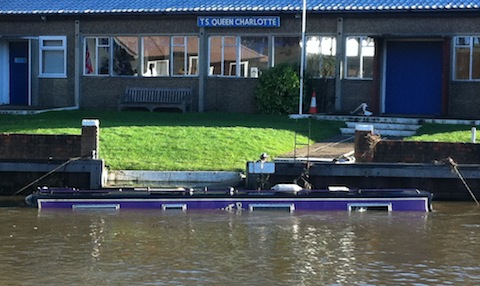
Cost of the flood: Submerged narrow boat moored in front of the TS Queen Charlotte, Guildford Sea Cadets HQ.
A flood alert for Guildford was not issued until mid-morning on Christmas Eve because the river level had not reached the level to trigger an alert, even though it had already broken its banks in areas of the town.
Telephone conference calls were held in the mornings of both December 23 and 24 between the Environment Agency, that is responsible for issuing flood alerts and warnings, the local authorities (county and borough councils) and the emergency services. But the message that no alert had been issued was reiterated delaying precautionary action.
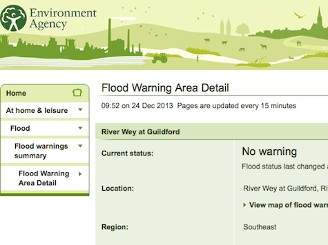
Screen shot of Environment Agency website taken at 1000hrs on December 24th. It shows no warning status for Guildford despite reports of riverbanks overflowing.
In the Guildford gates in the weirs, managed by the National Trust, had been fully opened days before the severe weather arrived, in anticipation of high water levels, to allow the river to flow through unimpeded and drain as quickly as possible.
An alert, “Flooding is possible. Be prepared.” was issued by the agency for the Upper Wey, which covers the river course down to Peasmarsh, just above Guildford, at 6.55pm on December 23, but, despite the continuous rain, an alert for Guildford was not issued until 10.11am on the 24th.
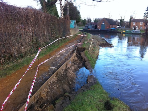
Cost of the flood: Part of the bank and towpath washed away by the flood near Dapdune Wharf.
An Environment agency spokesperson said: “Flood alerts and warnings are often issued sequentially as the river responds to rainfall and gravity moves water from the higher upstream sections to lower downstream sections.
“The time lag between alerts or warnings being issued from one reach to another can sometimes be considerable, depending on the gradient of the river the number of tributaries entering the river etc. We have a gauging station for the Lower Wey at Guildford, this did not show that levels had reached the point at which we would issue an alert until mid-morning on Christmas Eve.
“Levels increased quickly from that point, resulting in a flood warning being issued later that same morning. ”
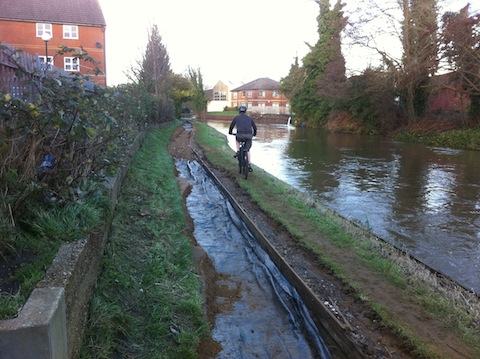
Cost of the flood: The floodwaters washed away the towpath of the River Wey between the town and the seven arch bridge, Walnut Tree Close.
Cllr Caroline Reeves, a Lib-Dem borough councillor for the most severely affected ward in Guildford, Friary & St Nicolas, said: “The flood warning appeared to be given very late in the day, given the huge amount of rain that had fallen.
“The river occasionally rises to the edge of the road at the Millmead car park during the course of any winter, so with the additional rainfall we had, it would seem obvious to the layman that the water would rise further.
“It’s very sad to see residents and businesses, many in my ward, affected by the flood water. While the council has offered help wherever possible, the inevitable influx of water can only be seen as disastrous for all concerned, homes and business alike.”
The council leader, Cllr Stephen Mansbridge and the council’s managing director, Sue Sturgeon, were also invited to comment but nothing has, so far, been received.
Share This Post


Responses to Environment Agency Confirms Alert Was Given After Flooding Had Commenced
Leave a Comment Please see our comments policy. All comments are moderated and may take time to appear. Full names, or at least initial and surname, must be given.

I'm living well for nothing at all! (See: No Trifling Matter: Magpie Trapped in Godalming Sainsbury’s)


Next stop, Debt Chasm! (See: We Should All Be Outraged About the Failure to Deal with Legacy Debt)


John Gibson
December 28, 2013 at 5:47 pm
The National Trust have now closed the towpath from Walnut Tree foot bridge to the railway bridge at Dapdune Wharf as a safety measure to protect towpath users.
Your pictures above clearly show the main area affected where the bank has been eroded greatly reducing the towpath width with a steep drop into deep water. There is a concern that the rest of the bank could give way while someone is walking or cycling along this stretch of the towpath with disastrous results for the individuals concerned.
Due to the depth of water at this location and the need to gain Land Drainage Consent from the Environment Agency for works within 8 meters of a main river it may be several months before the towpath and bank can be repaired and reopened. The cost of repairs will also be substantial and the Trust, as a charity, would welcome any donations towards the cost of reinstating the bank and towpath through the centre of Guildford – a well used pedestrian and cycling route into the town centre avoiding the busy road network.
The National Trust apologise for any inconvenience caused during this temporary closure of the towpath. Alternative routes along Walnut Tree Close or Bedford and Mary Roads are available.
John Gibson
Navigations Manager
Mary Bedforth
December 30, 2013 at 12:33 pm
I have just come back from a walk along the path that borders the river on the meadow side between the footbridge at St Catherine’s and the rowing club. The sensation of the rain being blown against my face was like being stung.
There were two large fallen trees to negotiate and, at the St Catherine’s end, there is a beach of golden sand washed up at Christmas. The river is full and fast flowing. The ducks, swans and gulls are enjoying the lakes. In Shalford Meadow adjoining the football pitches. I did not see the white egrets though.
I sincerely hope that any flooding will not be as severe as before but the five day forecast is grim.
There is no current flood warning when I looked at the Environment Agency site just now.
It states: “No warning. Flood status last changed at 13:07 on 27 Dec 2013
Location: River Wey at Guildford, Riverside Park Nature Reserve and Jacobs Well, Surrey”
Mary Bedforth
January 1, 2014 at 12:00 pm
I have just come home like a drowned rat from a walk along the towpath between Bowers Lock and Stoke Lock, along the boardwalk and back to the car park. I met one other person with his dog.
The river is obviously still full, fast running but not overflowing. Woe betide anyone taking a dip. One section of the river bank on the towpath has been washed away and a section nearby is showing cracks in the ground and looks likely to follow, so beware. Is the NT aware?
What is remarkable is the quantity of Guildford’s golden sand that has been deposited on both banks.
Hope GBC find their five barred gate plus posts that are missing since the flood. Where has it landed?
The boardwalk is excellent and, although it cost much more than the estimate, it is great fun and should last for many years. The old one was extremely dangerous. Children especially must love the new one with its artwork, the wooden sculptures and the hide.
Martin Giles
January 1, 2014 at 2:05 pm
Thank you for this interesting and useful update. All the scores of readers who were about to head off for a New Year’s swim (was there even one? please say) have been warned. Ed.