- Stay Connected
 Abraham Lincoln
If given the truth, the people can be depended upon to meet any national crisis...
 Guildford news...
for Guildford people, brought to you by Guildford reporters - Guildford's own news service
Guildford Company Use Video to Give an Impression of Medieval Guildford
Published on: 15 Jul, 2022
Updated on: 15 Jul, 2022
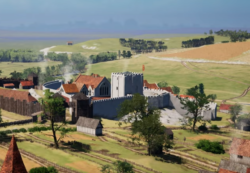
 A Guildford-based company which specialises in creating historical virtual reality experiences has produced a video of medieval Guildford town and castle.
Historic VR Ltd, based in Quarry Street, has made the video available to Guildford Heritage to roughly coincide with and celebrate the Museum’s Video Games – Made in Guildford exhibition.
Below Guildford’s well-known historian and author, Matthew Alexander writes an accompanying article. Matthew commented: “Historic VR Ltd have done a superb job. The glimpses that this video gives us evoke a Guildford long departed, although some echoes of it remain to this day.”
Explanatory article by Matthew Alexander
Hon Remembrancer for Guildford and former curator of Guildford Museum
This visualisation is of Guildford as the town would have appeared around 1300.
It opens approaching the town from the east, showing it lying in the valley which the Wey had cut through the chalk ridge of the North Downs. The river crossing, with its ford of golden sand, gave its name to the town. A stone bridge was built about 1200 by the monks of Waverley Abbey.
Perhaps the first impression is of the small size of the town, having a population probably less than a thousand. Nevertheless, it was the county town. Guildford owed this status to the dominant presence of the castle, the only royal castle in Surrey and the focus of county justice and administration. The video shows glimpses of the scattered buildings within the outer walls, making up one of the most luxurious palaces in England.
Another imposing building was the Dominican friary to the north, emphasising the importance of religion in the lives of the townspeople. There were also three parish churches, in fact, the only town in the county that had more than one.
Of St Mary’s, Holy Trinity and St Nicolas, only St Mary’s survives in its medieval form, though family chapels in both Holy Trinity and St Nicolas retain some early stonework.
Only the very wealthy could afford to build in stone, and nearly all the houses were timber-framed. However several along the High Street had expensive stone-vaulted undercrofts beneath them. These were intended as retail outlets, and at this time Guildford boasted no fewer than three wine merchants selling costly wines imported from Bordeaux.
The town had its weekly market, where farmers in the local area could bring in their produce for sale. The video acknowledges this by representing a market cross in the High Street.
The town’s prosperity came from the wool trade. Sheep grazing in the nearby villages were sheared and wool spun and then woven into cloth. The raw cloth came to Guildford to be finished, including dyeing. Much of it was dyed with woad, which caused the cloth to be known as Guildford Blue.
The video shows the drying racks for the dyed cloth at Millmead. The process was co-ordinated by the clothiers, entrepreneurs who paid for each step in turn before reaping the profits when finally sold. It was often exported to the continent, even as far as Italy.
Bird’s eye views show the layout of the town, with most of the buildings ranged on either side of the High Street, with long yards or gardens running to the rear. These plots had been laid out in the 10th century when Guildford was greatly enlarged.
Running around the town was a circuit of defensive earth ramparts and a ditch enclosing land on either side of the main London to south coast main road which ran through the centre. The land within that boundary was divided up into long narrow strips, still discernable as individual property boundaries today.


Recent Comments