- Stay Connected

Socialize

 Abraham Lincoln
If given the truth, the people can be depended upon to meet any national crisis...
Abraham Lincoln
If given the truth, the people can be depended upon to meet any national crisis...

 Guildford news...
for Guildford people, brought to you by Guildford reporters - Guildford's own news service
Guildford news...
for Guildford people, brought to you by Guildford reporters - Guildford's own news service
Guildford ‘On Borrowed Time’ for Flood Prevention Works
Published on: 4 Mar, 2022
Updated on: 7 Mar, 2022
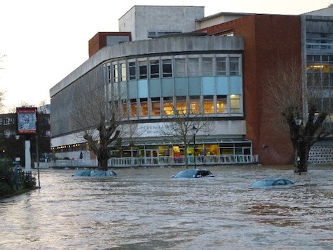
The 2013 flood at its height in Millmead.
By Emily Coady-Stemp local democracy reporter
and Martin Giles
Councillors say Guildford could be “on borrowed time” for work to sort flooding risks in the town centre.
Guildford Borough Council is applying for funding from Surrey County Council and from central government to avoid flooding such as the town saw in 2020 after Storm Dennis hit.

Cllr John Rigg
Cllr John Rigg, lead councillor for Regeneration, said at an Overview and Scrutiny committee meeting on Tuesday night (March 1) that he wanted to keep costs down for the borough council, and stressed the importance of being “on the list” for a share of £7 billion of central government funding.
He said: “The importance of flooding remediation, I can’t overstate.
“I think we are on borrowed time, when you start to see the weather change and how we get heavy rainfall.”
He said the council is working with the Environment Agency and engineers to get advice on how best to protect the town, mentioning serious flooding in 2014 and 1985.
He said: “We are trying to achieve two objectives. The first is to protect existing homes and businesses.
“And the second is to take what opportunity we can to release areas which so far we’ve only been able to use for surface car parking in the town centre, and other areas, which really we haven’t been able to productively use.”
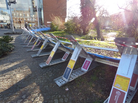
Temporary flood defences in place by Debenhams in Millbrook in 2014.
He said he was pleased with the engagement shown by the Environment Agency and the county council so far, having walked around the town with the Surrey leader Tim Oliver and one of the county’s directors for Environment, Transport and Infrastructure, saying they had been “very, very positive and very constructive”.
Cllr Rigg said the borough council would be applying for a £480,000 grant from the county council, and hoped to have an idea on the outcome by April.
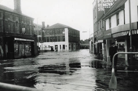
Onslow Street, Guildford during the 1968 floods.
The plan would be to do work in the town in zones, he said, and would include “landscape walls” in the town as well as “upstream storage” to help reduce flooding risk.
Cllr Rigg added: “When you’re doing one area of zone and you protect it against flood water, you’ve got to be very careful you’re not sending the flood water somewhere else where it’s unwelcome.
“So it is quite a complex project, but it is coming along pretty well. And I’m optimistic.”
Cllr Rigg said he was “looking much further ahead” and stressed the importance working with the Environment Agency to be on the list for central government funding.
He added: “I’m absolutely committed to trying to mitigate our costs and get as much government assistance as we can.
“But can I forecast the future perfectly? No. But at the moment, I’m happy with where we are.”
Yesterday (March 3), asked by The Dragon NEWS why is this only emerging publicly as an issue now when it has been a problem for years, Cllr Rigg responded: “Absolutely. I do not understand why, hitherto, with the history of flooding in Guildford and now with climate change we have failed to address this issue and take precautions to protect our town.
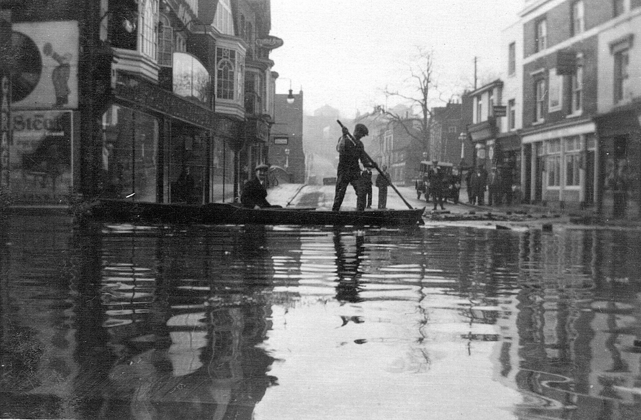
Guildford floods are nothing new this picture taken at the bottom of the High Street, looking west towards The Mount, was taken in 1928.
This is especially so when being in an area susceptible to flooding means you blight areas and cannot get planning consent to regenerate town centre sites to deliver the homes and employment space we desperately need. For decades now this issue has been swept under the carpet .
“Politicians have failed to face up to the obligations they have to the community probably because it is difficult to solve takes time and is costly. The planning of the town and especially the last Local Plan 2019 avoided resolving the issue entirely and was partly the reason why new development had to be pushed onto our green belt, the worst possible place.
“We are now addressing the challenge with the help of the Environment Agency and hopefully Surrey County Council as part of the new Masterplan ‘Shaping Guildford’s Future’. It will take time but we are on the case and with the support of the community we are optimistic flooding can be resolved to create a better safer Guildford.
“To remind everyone of Guildford’s history of flooding: the worst flood in living memory was in 1968 where significant parts of the town were flooded; this affected people, houses, major roads, railway lines and businesses.
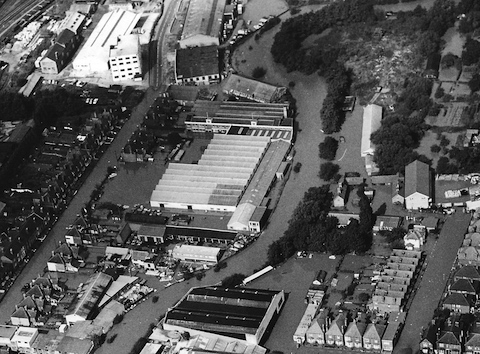
An aerial view of a part of Guildford during the floods of September 1968. Walnut Tree Close is on the left.
“Other serious floods occurred in:
- winter 2013 to 2014 with 92 properties flooded
- 2000 with 29 properties flooded
- August 2018 when a heavy downpour overwhelmed the surface water drains in the town centre and caused flooding to properties and businesses.”
Share This Post


Responses to Guildford ‘On Borrowed Time’ for Flood Prevention Works
Leave a Comment Please see our comments policy. All comments are moderated and may take time to appear. Full names, or at least initial and surname, must be given.

I'm living well for nothing at all! (See: No Trifling Matter: Magpie Trapped in Godalming Sainsbury’s)


Next stop, Debt Chasm! (See: We Should All Be Outraged About the Failure to Deal with Legacy Debt)


Jim Allen
March 4, 2022 at 2:42 pm
Simple solution – set the intermediate sluices and correctly set the overspill height above old Bucks weir. It would take minutes, not days, months or years.
John Perkins
March 5, 2022 at 10:00 am
Three decades ago when water authorities were privatised, one of the first things the new management did was rid itself of all the old “dead wood”. New graduates were taken on in their place. Lockkeepers were “let go” so their valuable homes, next to the sluices, could be sold off for profit.
After a couple of years, a crisis arose at a location on the Thames and none of the highly educated staff knew how to deal with it. They called in an old expert, but by the time he arrived on his bicycle several million gallons of untreated water had been pumped towards a major town.
It used to take a phone call to set the sluices correctly, whereas now it takes a committee meeting to organise a person on a bike, by which time the damage has been done and the new setting is out of date.
John Lomas
March 6, 2022 at 1:45 pm
John Perkins’letter prompts me to ask. What has happened to the two lock keepers’ monthly columns which were, I am sure, appreciated and enjoyed by many?
Editor’s response: The lengthsmens’ reports stopped during the pandemic. We will ask the National Trust if they are to be resumed.
Bibhas Neogi
March 10, 2022 at 9:23 am
It is reassuring to hear from Cllr John Rigg that the plan would be to do work in the town in zones, and that would include “landscape walls” in the town as well as “upstream storage” to help reduce flooding risk.
However, the Environmental Agency has said (in https://www.gov.uk/government/publications/guildford-flood-alleviation-scheme/guildford-flood-alleviation-scheme) “We also investigated storing floodwater upstream of Guildford. We looked into whether this could lower the height of the flood defences in the town centre but still provide a high level of protection. However, delivering upstream storage is facing considerable technical, environmental and cost issues. Therefore it is unlikely to go ahead.”
I believe this needs major rethinking as upstream storage and the walls in the town stretch of the river are the only real answer.
Walls along the riverbanks would increase the capacity of the river to discharge the flow down to flood plains downstream but upstream storage would be required to control the flood water so that it remains within the barrier walls in the town.
I have mentioned the possibilities very briefly in my document https://tinyurl.com/traffic-and-bus-station as to how these upstream reservoirs could be created in the flood plains by forming storage lakes and pumping water back to the river in a controlled manner.
Flood control is necessary if Bedford Road, the Wharf area and Walnut Tree Close are to be protected. Pumping could use renewable energy generated on or along these reservoirs and on floodplain sites. These lakes may be used for leisure and the islands in the middle for restaurants etc. while the outer areas could form gardens for visitors to the areas. Maybe there is an opportunity for businesses to collaborate with the Environmental Agency?