- Stay Connected

Socialize

 Abraham Lincoln
If given the truth, the people can be depended upon to meet any national crisis...
Abraham Lincoln
If given the truth, the people can be depended upon to meet any national crisis...

 Guildford news...
for Guildford people, brought to you by Guildford reporters - Guildford's own news service
Guildford news...
for Guildford people, brought to you by Guildford reporters - Guildford's own news service
Letter: We Can Now See That Damming the Flood Plain Would Be Plain Wrong
Published on: 25 Dec, 2013
Updated on: 25 Dec, 2013
 From Jim Allen
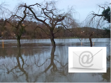
Notwithstanding wishing everyone a very Merry Christmas and festive cheer, this flood, which has effectively levelled the weir upstream of Bowers Lock, is teaching us a timely lesson.
I suggest that everyone who has photos of the floods send them to Guildford Borough Council and Surrey County Council. The idea that we build on the flood plain at Slyfield, including the proposed “Stoke Road – Clay Lane link road” is plain wrong. It would dam the flood plain (which, at the time of writing, seems to be trying to imitate the River Amazon) and should be stripped from the agenda.
Mother Nature has just proven she likes to breath heavy some times. She busts her corsets no matter how hard man tries to contain her. We need our flood plain left as is, so that it slows the flow further down stream and can take up the excess from up stream.
By the way, I would like to thank the Wey navigation team for their hard work maintaining the sluices which at present are overwhelmed at Stoke and Bowers Locks. The water level is some four inches over the tops of the locks.
Your thanks to the navigation team is well said Jim. We should not forget their sterling efforts to minimise the flood damage, often when the rest of us our safe in our homes. Ed
Share This Post


Responses to Letter: We Can Now See That Damming the Flood Plain Would Be Plain Wrong
Leave a Comment Please see our comments policy. All comments are moderated and may take time to appear. Full names, or at least initial and surname, must be given.

I'm living well for nothing at all! (See: No Trifling Matter: Magpie Trapped in Godalming Sainsbury’s)


Next stop, Debt Chasm! (See: We Should All Be Outraged About the Failure to Deal with Legacy Debt)


Frank Phillipson
December 26, 2013 at 12:42 am
I think the proposed road would be from Slyfield Industrial Estate (Moorfield Road or North Moors) to Clay Lane. If this was northwards along the side of the flood plain to Clay Lane near to the Chambers Waste Management entrance, it might be acceptable? However I haven’t seen any proposals so do not know any of the details.
Mary Bedforth
December 26, 2013 at 8:36 am
I concur with Jim Allen.
And RIP Bob Dearnley, Burpham Court Farm, May 2009. I often think of him when I walk on the towpath and see the flooded land. I hope that his widow and daughter have found some happiness in the intervening years.
Martin Elliott
December 26, 2013 at 9:30 pm
I’d agree with Frank, without firm proposals comparison to the flood area maps from the EA can’t be made. It does appear to be along the edge of the flood plain that’s confirmed every 5 years or so.
Jim Allen
December 27, 2013 at 6:01 pm
The current proposal iIsis for a road between the farm and bottom of the slope right across the middle of the flood plain.
Such a road should not even be considered. It is not needed commercially and it will fail to provide a solution to the traffic problems which could be solved by simply improving the Slyfield ‘front door’ which has a current capacity of just two cars. This causes the only problem in Slyfield: inability to enter and leave the estate.
A simple re-adjustment of the traffic lights to green one way, red the other two, would solve the problem in the short term and increase the junction capacity to somewhere near maximum. But, i believe it suits SUrrey County Council to have the delays so they can claim there is a need for a new road. I can think of no other reason.
The implications of any building in the flood plain of the River Wey will simple end in an ‘Aral sea disaster’ as the flood waters are chanelled tighter into the valley, forcing Send and Woking to take it all, and raising the designed flood prevention schemes, many in which have worked since the 1600’s.
If anyone is thinking of supporting this foolhardy proposal I suggest they do some home study on water hydraulics and the effects of preventing water escaping, before making comments.
Central Guildford might not have flooded so badly if the banks of the river closer together by several metres simply to build new devopments right up to the bank. Just think how quickly and how much water could have left Guildford if the reiver had been one metre wider at two metre depth, thats an awful lot of water that could have passed through the town which couldn’t just because, it seems to me, greed took over from engineers.
Sean Jenkinson
December 28, 2013 at 10:02 am
Maybe if the council had not backed down to the protesters when they were going to make the Woking road wider there would not be a problem now.
I worked on Slyfield industrial estate for five years and something needs to be done. It is a large industrial estate and it is mad to have just one way entrance/exit. They need to build another plus revisit the plans to make the Woking road wider.
I’m sure there are ways to build just a road on the flood plain without it becoming a dam. Maybe make it a low road bridge. But to build anything other than a road would be silly.
Bibhas Neogi
December 28, 2013 at 3:29 pm
Sean Jenkinson is right in saying that a road on the flood plain could be built without it becoming a dam. There are many examples of viaducts over flood plains and tidal waterways.
I don’t know the history of Clay Lane but it looks like it has been built smack in the middle of Wey’s flood plain with two bridges over the main channels. There may well be other cross-drains not visible from the road due to overgrown vegetation. I have no doubt Surrey County Council would employ engineers with adequate knowledge of hydraulics and flood control.
The point is that a better connection and access to Slyfield Industrial/regeneration area is needed and a connecting road to Clay Lane would be an advantage. However, I can appreciate Jim Allen’s reluctance to Clay Lane having more traffic since this might damage the attractiveness of the area.