- Stay Connected

Socialize

 Abraham Lincoln
If given the truth, the people can be depended upon to meet any national crisis...
Abraham Lincoln
If given the truth, the people can be depended upon to meet any national crisis...

 Guildford news...
for Guildford people, brought to you by Guildford reporters - Guildford's own news service
Guildford news...
for Guildford people, brought to you by Guildford reporters - Guildford's own news service
Letter: My Response to Niels Laub’s Letter on the London Road Scheme
Published on: 3 Oct, 2023
Updated on: 3 Oct, 2023
 From: Matt Furniss
Conservative county councillor for Shalford division
In response to: Some Concerns About the London Road Active Travel Scheme
I would like to thank all of the stakeholders and residents for their time and input into the scheme so far, which I believe is an improvement on the original proposal.
Under the current proposal, SCC are proposing night works only with no road closures or traffic lights along the London Road during the day. There will be some night time closures, while still allowing access for residents. Works if agreed would take place during school holidays.
I urge all residents and readers to view the videos and information available online at: https://burpham-activetravel.commonplace.is/
Or at one of the drop-in sessions on the following dates:
- Wednesday, October 4 Burpham Church, New Inn Lane 6.30pm to 9pm
- Saturday, October 14 Guildford High School, London Road 10am to 2pm
- Wednesday, November 8 Guildford High School, London Road 6.30pm to 9pm
Residents’ and readers’ views are important to us, and their input would be greatly appreciated.
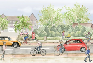
Surrey County Council (SCC) is proposing this scheme which aims to improve safety to a key walking and cycling route in Guildford and contribute towards the council’s strategic objective to achieve net zero carbon emissions by 2050.
Responses to the Niels Laub’s letter. The paragraph numbers below correspond to the numbers in his letter.
1. We acknowledge that road space is challenged in front of Guildford High School for Girls and that is why we propose to install a shared use path in the frontage of the school for use by less experienced cyclists.
This will be combined with traffic calming and reduction of the speed limit to 20mph on the adjacent carriageway so it can be safely used by experienced cyclists. Signalised crossing facilities have been provided at each end of the shared use path to facilitate its use.
Therefore, it is not the case that all cyclists are required to cross the road onto a shared pavement outside the High School as stated in this letter.
2. The minimum width of shared-use paths being provided outside the Emporia is 1.9m and this is for a distance of 50m on the southbound side and 32.1m on the northbound side of the road. It is noted that Table 6-3 of LTN1/20 recommends a minimum width of 3m for shared-use paths, but this is for shared-use routes carrying up to 300 cyclists/hour.
This is very high compared to the forecast (with intervention) usage level of up to 400 cyclists/day. Furthermore, the width of the shared-use facility we are proposing is equivalent to or wider than the total width of the existing footway plus advisory cycle lane.
6.5.6 of LTN 1/20 recommends that a length of shared use may be acceptable to achieve continuity of a cycle route.
3. There is currently a mandatory cycle lane running parallel to the footway in front of Kingpost Parade. However, the width of the cycle lane is less than 1m and well below the absolute minimum width of 1.5m recommended by LTN1/20 for cycle lanes at constraints.
This is one of the reasons why we are proposing to widen the footway into a shared-use facility with widths of 3m-4.5m.
4. Following representations from disability groups and consultation with SCC’s Passenger Transport Group, we are proposing shared use areas for all the bus stops in the scheme. Therefore, what we are proposing for the Burpham Shops bus stop is not an exception.
Responses to other key issues raised
a. Carriageway Widths
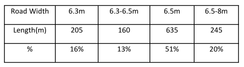
SCC are not proposing to reduce any lane widths to 3.1m as stated in the letter. The table below provides the widths we are proposing over the 1.245km length of the Burpham scheme.
It shows that we are proposing widths in excess of 6.5m for 71% of the length of the scheme with a minimum carriageway width of 6.3m being proposed for 16% of the scheme length. The figures presented within the original letter indicate that 6.3m carriageway width is adequate for HGVs.
 b. Separation between cycle paths and the carriageway
While LTN1/20 recommends a minimum 0.5 metres separation between cycle paths and the carriageway in a 30mph urban zone (refer to Table 6-1 on page 54). It also recommends an absolute minimum horizontal separation of zero (0) m and our design meets this standard.
c. Absence of bus lay-bys
We only propose to remove the bus lay-by at the Highclere (northbound) bus stop on the approach to the Weylea/Woodruff. This is not expected to have any significant impact on network capacity because there are invariably delays at either the signalled pedestrian crossing or on the approach to the New Inn Lane roundabout or both downstream of the roundabout.
Therefore, if drivers are delayed behind buses while they allow passengers to embark and alight, they will be released into lighter traffic and the overall journey time along the route is likely to be the same or only slightly impacted.
d. Impact of narrow carriageways on the operations of the emergency services
We have discussed the carriageway widths we are proposing with the emergency services and they do not consider it as an issue.
e. Impact of the introduction of 5 additional signalised crossings on traffic congestion
It is proposed to introduce five additional signalised crossings along A3100 London Rd.
However, three of the proposed signalised crossings will be replacing existing uncontrolled crossings and two are on existing or proposed pedestrian desire lines. It is not clear what is wrong with providing a facility that would improve the safety of pedestrians and cyclists including school children, in fact, it will be a significant improvement.
f. The introduction of parallel crossings linking shared-use paths does not meet the required standards
LTN1/20 does not say that parallel crossings shall never be used to link sections of shared-use paths. In fact, Fig 10.38 of LTN1/20 shows a parallel crossing linking shared-use paths at a roundabout in Bournemouth.
In any case, Cycle Embassy of Great Britain does not set the standards for the design of active travel schemes.
However, it would be great if Mr Laub can share a copy of the particular Cycle Embassy of Great Britain standard he is referring to or provide us with a link to the document.
g. Long stretches of the cycle paths are only 1.4 metres wide
The cycle tracks we are proposing will have a minimum width of 1.5m, which is the absolute minimum recommended by LTN1/20.
h. The majority of the new cycle paths are designed to minimum standards, or even less than minimum standards, rather than optimum standards.
There is nothing wrong with designing new cycle paths to recommended minimum standards.
i. The introduction of a Dutch-style roundabout at Boxgrove Roundabout will have a significant impact on traffic at a busy junction.
We are still in the process of finalising the modelling for the Boxgrove roundabout scheme and will share the report as soon as it is ready. It is therefore not clear what SCC modelling the author is referring to as no information about modelling of the current proposal has been published.
j. In order to introduce cycle paths beside Stoke Park they have removed approximately 180 metres of parking which equates to approximately 30 parking bays.
We propose to reduce the number of parking spaces beside Stoke Park from the current 57 (in 4 zones) to 48. This equates to a reduction in parking bay length of 45m and not 180m as quoted incorrectly in the original letter. The results of parking surveys we have undertaken also indicate that there is adequate excess parking spaces available in the immediate vicinity to accommodate any parking displaced from the parking
spaces beside Stoke Park.
k. Bus stops generally have not been designed in accordance with LTN 1/20
Our initial designs included four bus stop bypasses (floating bus stops) which meet the LTN1/20 standard referred to above with shared-use bus stops being provided at the remaining bus stops owing to highway constraints.
For the shared-use bus stops, cyclists are directed to the rear of the bus shelters while pedestrians/ bus passengers are directed to the front of the bus shelter. However, following representation from disability groups, we have replaced the four bus stop bypasses with shared-use bus stops.
l. The introduction of a section of “cycle street” immediately outside the High School is not consistent with the concept of “quiet mixed traffic streets” as described in Chapter 7 in the LTN 1/20.
7.1.1 of LTN 1/20 states inter alia that “most people, especially with younger children, will not feel comfortable on carriageways with more than 2,500 vehicles per day and with speeds of more than 20mph.
These values should be regarded as desirable upper limits for inclusive cycling within the carriageway.”
Figure 4.1 of LTN1/20 also indicates that mixed traffic on a 20mph road with a motor traffic flow of approximately 2000 pcu/24hr is suitable for most people.
It is for the above reasons that we are proposing:
- a mixed traffic street with speed limit reduced to 20mph and targeted at experienced and confident cyclists and
- a shared-use facility for less experienced cyclists such as younger children and adults accompanying them. Signalised crossing facilities have also been provided at both ends of the mixed street to assist cyclists seeking to switch between the shared-use facility and the segregated facility on both sides of the road.
m. These proposals for Active Travel should attempt to improve matters for road users by making it safer for cyclists and pedestrians.
In reality, because there is insufficient space, the proposals are likely to make it more hazardous for cyclists and pedestrians and are likely to increase traffic congestion and air pollution in the area.
Our proposals will be subjected to the appropriate levels of road safety audit at the various stages and this will highlight problems which could potentially pose a hazard to cyclists and pedestrians and also make recommendations for mitigating them.
We are also in the process of finalising the traffic modelling for the scheme and the results would give us an indication of the potential impacts of network capacity. We will share the modelling results with stakeholders when they are ready in the next few weeks.
Share This Post


Responses to Letter: My Response to Niels Laub’s Letter on the London Road Scheme
Leave a Comment Please see our comments policy. All comments are moderated and may take time to appear. Full names, or at least initial and surname, must be given.

I'm living well for nothing at all! (See: No Trifling Matter: Magpie Trapped in Godalming Sainsbury’s)


Next stop, Debt Chasm! (See: We Should All Be Outraged About the Failure to Deal with Legacy Debt)


Niels Laub
October 3, 2023 at 5:10 pm
One more thing that concerns me about Surrey County Council’s determination to go ahead with this Active Travel Scheme proposed for the London Road is public safety.
In their letter giving Notice of the Public Consultation, the Surrey County Council state “Surrey has the highest number of cycling casualties in the UK and we want to help address this by providing safer cycling spaces across the county”.
This is highly misleading as it refers to the whole of Surrey and not London Road which has a relatively good safety record. This statement is particularly galling bearing in mind that the only other Dutch style roundabout in Cambridge has seen an increase in accidents since its installation. There have been ten collisions since the roundabout opened at Fendon Road in Cambridge in 2020, three of them serious, compared to six minor incidents 2017-2019. The ten collisions included eight involving cyclists, and the other two involved a pedestrian and a driver respectively. https://www.bbc.co.uk/news/uk-england-cambridgeshire-65310167
Jim Allen
October 3, 2023 at 5:43 pm
“We are no longer proposing to narrow the width of the road to six metres!” So says the SCC Letter which arrived today, 20 plus days after the consultation started.
Mandatory cycle lanes need consultation and Paperwork. and as Surrey CC have refused to display the previous cycle lane paperwork, which I formerly requested along with all Road Traffic orders last January, we have no proof of current legality
So we must stress we are discussing kerb to kerb dimensions! The bit of the road used by everyone
not the fading white paint, used throughout, Not Phantom cycle lanes with no displayed legality!
Thus if you see the drawings stripped out, up to 1 metre width is being lost to the majority of road users at new Inn Lane and kingpost!
In Engineering the word ‘minimum’ is not the ‘target to meet’ but something you should never ever go below. In politics it may mean something else!
Parallel crossing should be inline with the cycle path as cranking them into the junction flair / recess, places the priority cyclist into a blindspot of vehicles turning left. Thus this is clearly ‘unsafe real life practice’ and they should not be from combined paths, again bad safety practice! Safety is about understand reality; cause and effect, not the politics of cost or party policy.
Sadly SCC are making up rules as they go along, as SCC has decided to do so in their transport plan; by dismissing/excluding the Bridges and Roads manual the national guidance documents, it never was a good idea!
The biased survey multiple choice questions is as expected majority of current 174 respondants ‘positive answers’ as SCC will claim for the scheme and little wonder, the way it is worded so predictable, but the 140 plus ‘comments’ tell a far different story, of safety concerns, actual need, road widths and lack of modelling etc.
In short, there are serious questions of safety in reality, mine specifically on New Inn lane using Parallel-crossings.
I fear the arrogance of Surrey CC clrs will land Burpham with a dangerous white elephant at New Inn Lane junction. (The cycle lane may fit further along at Stoke Park of which I make no claim of knowledge, but someone said there is already one in Stoke Park!)
Installed;
Not because of improved movement safety of all road users,
Not because the users of London Road asked for it.
Not because the sale of push bikes has demonstrated need
Not because the accident rate on London Road is the highest in Surrey or even Guildford. London road appears to have the lowest accident rate of any entry road to guildford these past 23 years overall!
But just to prove Clr Furniss is in control!
Jim Allen
October 3, 2023 at 6:10 pm
Cd195! Bridges and roads manual! Parallel-crossing
J Dickinson
October 4, 2023 at 12:37 am
Well said, Matt. Thanks for taking re time to respond so comprehensively, and for championing this scheme. Replacing the non-compliant cycling provision around our schools and leisure facilities will give generations of residents the freedom that most Guildford Dragon readers enjoyed as children: travel independence.
J Dickinson
October 4, 2023 at 12:43 am
Well said, Matt. Thanks for taking the time to respond so comprehensively, and for championing this scheme. Replacing the non-compliant cycling provision around our schools and leisure facilities will give generations of residents the freedom that most Guildford Dragon readers enjoyed as children: travel independence.
(Typo corrected!)
Iansss
October 4, 2023 at 9:02 am
SCC launched this scheme for consultation before it was fully designed, they got lots of criticism and withdrew it. Now the ‘revised’ scheme is out for consultation, but it isn’t yet fully modelled. What could pissibly go wrong?
Sam neatrour
October 5, 2023 at 10:45 am
Such a great idea. Everyday I cross Epsom road with my young daughters to cycle to school. Everyday we run the gauntlet of speeding motorists. The faster cars go, the more likely they are to be hit by a speeding car. The faster cars go the more likely they are to be killed or injured when hit. Surrey CC have registered an average speed of 34 mph on Epsom Road. Only one of the speeding cars needs to hit a child, the whole family will mourn its loss. We are a nation of families
We can only dream of such a scheme for Epsom Road allowing my children to cycle or walk to school bit more protection than a pavement to walk along in single file.
Chloe Sutcliffe
October 5, 2023 at 11:09 am
As a mum of young children I think the proposed changes will be a vast improvement on what is currently in place in terms of safety for cycling. It is incredibly disappointing to see the amount of opposition that has been stoked towards this scheme locally. Schemes such as this, which increase uptake of active travel alternatives to private car use, are exactly what towns and cities need to improve air quality, population health and road safety, and to reduce emissions. They are very much in the interests of the young people of today, who will be saddled with enough problems in future as things stand. I suspect many who oppose these kinds of schemes are of an age where they are not primarily concerned with what our towns will be like two decades from now. The interests of younger and future generations should take priority in the implementation of schemes such as this, since they are the ones who will live for longest with the consequences. It is good that Surrey County Council are engaging local people to help shape the details of this scheme appropriately. Personally, I am really looking forward to using the new cycle lanes with my family when they are ready.
Niels Laub
October 11, 2023 at 8:15 am
At the Emporia, the width of the road including pavements, is 10 metres. I have checked this with a laser measuring device. If, as Cllr Furniss says, the shared pavements on either side are 1.9 metres, it follows that the carriageways in each direction can only be 3.1 metres. This means that HGVs and buses travelling in opposite directions will be separated by only 150 mm which is clearly very unsafe.
According to Table 6-3 of LTN1/20 [Department of Transport’s Cycle Infrastructure Design], the minimum width of shared pavements should be three metres and, according to Table 5-3, because they are next to walls exceeding 600 in height, this should be increased to 3.5 metres.
I would therefore suggest that 1.9 metre shared pavements are not compliant and are unsafe. According to the drawings, these shared pavements extend for 100 metres northbound and 120 metres southbound which is double the length you suggest.
Table 6-1 on page 54 recommends a minimum 500 mm separation between cycle paths and carriageways in a 30mph urban zone. No such separation has been provided anywhere throughout this scheme.
This is a highly significant safety issue, particularly bearing in mind the restricted carriageway widths. The Highway Code suggests a minimum overtaking gap of 1.5 metres between a vehicle and a cyclist which is unachievable with these proposals.
It is disappointing that such an important scheme has been designed to absolute minimum standards rather than optimum or even recommended standards. These proposals for Active Travel should be attempting to improve matters for all road users by making it safer for cyclists and pedestrians.
However, because there is insufficient space, the proposals are likely to make it more hazardous for all road users including cyclists and pedestrians and are likely to increase traffic congestion and air pollution in the area.
Traffic accidents
According to BBC News, the only other Dutch-style roundabout in Cambridge has seen an increase in accidents since its installation. There have been ten collisions since the roundabout opened in 2020, three of them serious, compared to six minor incidents 2017-2019. The ten collisions included eight involving cyclists, and the other two involved a pedestrian and a driver respectively.
Traffic modelling
Regarding traffic modelling at the Dutch-style roundabout, I was referring to the conclusions of SCC’s own traffic modelling which states that “the Dutch-style roundabout created poor performance on all arms. With an 11 per cent decrease in overall capacity, queue lengths and delay times increased to unsuitable levels. A 260.1 second delay was anticipated as the longest queue”. Surrey County Council are still refusing to release the data.
Cycle Embassy for Great Britain
Regarding the parallel crossings at New Inn Lane and Woodruff Avenue, The Cycle Embassy for Great Britain states that parallel crossings should never be used to link sections of shared pavement. Please refer to http://www.cycling-embassy.org.uk/dictionary/parallel-crossings
Bethan Moore
October 13, 2023 at 10:37 am
I would ask others to please stop using feigned concerns about safety to attempt to block this scheme.
Some elements could be better if the whole road was being built from scratch. But it’s not being built from scratch. Every element of the scheme is by some degree an improvement for pedestrians and cyclists compared to what we have now and what we would be left with. Roads are for people and the most vulnerable of those people should come first.
Jim Allen
October 13, 2023 at 2:17 pm
The use of the word feigned strongly suggest ms Moore has no understanding of the word safety.
As to how it applies to a pedestrian walking at 3mph and a cyclist travelling in excess of 15mph!on the same area
Roy Darkin
October 20, 2023 at 10:57 am
They are genuine concerns. I am dead against the proposed Dutch roundabout as making it more dangerous than it already is. Also banning the right hand turn into York Road will cause chaos.
Mark Percival
October 13, 2023 at 9:36 pm
Mr Laub reiterates numerous factual inaccuracies. I have submitted explanations of this but they have not been published.
He represents the LRAG group and is a seasoned campaigner to prevent any change or improvement for the benefit of the wider community.
One point that should be raised, an area with less cars and more walking and cycle options can have 11% higher house prices (Savills report).
Burpham will have lower desirability and so house prices will reflect that families will not want to live in a high traffic, high HGV area such as Burpham versus other areas.
Mr Laub and the other perennial complainers are campaigning for more HGVs, as they seem more concerned about the safety of lorries versus children and other vulnerable groups.
Malcolm Stanier
October 11, 2023 at 5:37 pm
It would be interesting to know the actual author of the technical aspects of Cllr. Furniss’ reply or perhaps that’s secret as well? Also of note is the clear indication that the expected level of utilisation is a “usage level of up to 400 cyclists/day” which is quoted to justify the below standard width of shared use paths. So that’s £4 million for UP TO 400 cyclists.
What happened to Surrey County Council’s leader, Cllr Tim Oliver’s it would be “madness” to go ahead with a Guildford road improvement scheme in the face of “huge opposition”? And the Prime Minister, Rishi Sunak’s comment about “hare-brained” traffic schemes and how penalising drivers going about their daily lives “doesn’t reflect the values of Britain”.
It seems that this scheme (and others) is going ahead despite the unlikely event that great numbers of drivers will ditch their vehicles and hop on a bike. There are still going to be lorries, vans and buses with the likelihood of car drivers giving up their vehicles in anything like the numbers the proponents hope for being “pie in the sky”.
Andy Friend-Smith
October 11, 2023 at 6:13 pm
As a regular user of London Road both as a cyclist (roughly three times per week) and driver (roughly once per week), I would like to applaud the team for the work they have done in designing this scheme. As others have noted, it’s not perfect in every respect, largely due to space constraints, but it will be considerably better than the existing “white paint” cycle lanes which are wholly unfit for purpose. The more we can make cycling/wheeling/walking an attractive alternative to driving, the more likely people will be to adopt these modes of transport, thereby freeing the road space for those who need to use cars and other motorised vehicles. This scheme in isolation won’t be the immediate panacea for Guildford’s traffic issues, but it’s a big step in the right direction and hopefully the blueprint for future schemes. Let’s give residents of our town, especially the next generation, safe, healthy, and appealing alternatives to car use.
jim allen
October 12, 2023 at 5:11 pm
What the people say from the Survey! mid term assessment
420 Understand the plan
197 made a political statement
73 didn’t understand the plan
129 were supportive of the plan
145 made neutral comments
421 made negative comments
Taken from 697 sentences downloaded from common place.
single “concern” words from these same sentences.
Access 1; Benefit 1; comment 2;Congestion 1;
Financial 45; Observation 237; Problem 357; Question 20;
request 1;Safety 22;Statement 2;Stats 5; Suggestion 2; Vehicle 2
SO if you take the multiple choice questions they get the perceived predictable answers, if you read the text in the ‘free flow answers’ you get a very different view of the situation.
Few if any knew of the ‘New Zebra crossing’ outside the project area behind Sainsbury recently included.
Few know the traffic modelling is still outstanding,
Few realised that the statement (in the letter distributed) “we are no longer proposing to narrow the width of the road to six metres instead will remain the same width as it is currently; is a blatant falsehood” There is a loss of up to or exceeding a metre through Burpham King Post area and the entrance to New Inn Lane is being substantially changed in width as can be seen on the AO drawings supplied by SCC. Stripping the drawings down electronically displays this falsehood.
The measurements on the Stoke Park side part 3 of the project have had the old road dimensions removed prior to adding new dimensions thus the narrowing on this side cannot be ascertained but clearly has occurred else why remove the old lines.
J Dickinson
October 15, 2023 at 11:05 am
Well said, Matt. Thanks for taking re time to respond so comprehensively. I have attended one of the drop in sessions, which was very well organised and the engineers present answered all of my questions.
To Niels, who makes it clear he is dead set against making room for cyclists and pedestrians, I remind him that cyclists are traffic. When most Dragon readers were children, we got ourselves around on foot, by bike or on public transport because our parents were confident about our safety. These days, children are ferried to and from school and to and from their clubs in cars because their parents don’t think the roads are safe. That’s a lot of extra traffic at the times when London Road is busy. This scheme will provide would be cyclists with protected space on which to ride. These days, when the mass of cars is so much higher and hence damaging in collisions, that’s what is needed to encourage parents to stop using cars and let their children back on their bikes. We didn’t “need” to be ferried in cars, and with this investment, in the future neither will children at local schools.
J Dickinson
October 21, 2023 at 11:04 am
As Niels Laub is worried about the width of the vehicle lanes of this scheme, perhaps some camera-enforced additional constraints are needed to ease his concerns?
At the specific times when there are many more vulnerable road users around, travelling to the schools and the leisure centre, let’s ask for evidence of the local need for heavy, wide vehicles to be able to travel freely.
There is plenty of evidence why they shouldn’t be in the mix https://actionvisionzero.org/2020/07/09/pedestrian-fatality-risk-and-engine-size/.
Consumer pressure from families could help explain why the area’s high-spending residents would prefer that HGVs and trucks choose to avoid the peak hours. Supermarkets tend to schedule deliveries when their stores aren’t busy and, in any case, the local ones have alternative routes.
The scheduled bus services could be swapped to demand responsive versions as commissioning is in Surrey County Council’s gift. Can Niels/the lobby group please provide a list of the local businesses that want to keep their large trucks on these roads?