- Stay Connected

Socialize

 Abraham Lincoln
If given the truth, the people can be depended upon to meet any national crisis...
Abraham Lincoln
If given the truth, the people can be depended upon to meet any national crisis...

 Guildford news...
for Guildford people, brought to you by Guildford reporters - Guildford's own news service
Guildford news...
for Guildford people, brought to you by Guildford reporters - Guildford's own news service
Where Is This? No.139
Published on: 10 Dec, 2014
Updated on: 10 Dec, 2014
By David Rose
A view of the building on the corner of High Street and Quarry Street was last week’s mystery vintage photo and a number of readers correctly identified it.
Click here to see last week’s post and all the replies at the foot of it, with, as usual, plenty of extra detail. I think James Dix may be right in suggesting the event taking place as the picture was taken was perhaps Guildford’s celebrations at the end of the Boer War or the coronation of Edward VII.
The quirky photo, taken by Dan James with his remote-controlled drone helicopter, was high above Westborough with the Guildford Business Park in the middle distance. Several readers – including John Lomas, Terry Stevenson, the Staniforth Brothers (speedboat or caravan prize hopefuls) and Chris Townsend, etc – correctly worked all that out and gave details of other places of interest in view.
Where is this?
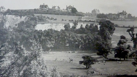
This week’s vintage mystery picture is another image from the collection at the Guildford Institute and another far-reaching view, this time dating from the early 20th century. Large houses on the horizon, an exposed area of chalk, cows grazing in the field at the foot of the picture. Where on earth (Guildford) can it be? And where was the view taken from?
Surely this is not evidence of Roman occupation in Guildford? Do you know where this is?
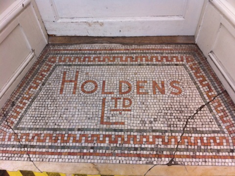
This week’s quirky picture came about after I was given a tip off that there were some interesting old bottles for sale at a Guildford charity shop. An antique bottle collecting friend of mine usually gets there first, but I went to see, and although the bottles were still there, unfortunately, they weren’t really old enough for my liking or interest.
Nevertheless, what I did spy was this interesting mosaic tile advertising a long-gone Guildford business. Do you know where it is and who Holdens were?
If you know the answers and can perhaps add some details, please leave a reply in the box below. Replies and the answers, along with two more mystery images will be published at about the same time next week.
Share This Post


Responses to Where Is This? No.139
Leave a Comment Please see our comments policy. All comments are moderated and may take time to appear. Full names, or at least initial and surname, must be given.

I'm living well for nothing at all! (See: No Trifling Matter: Magpie Trapped in Godalming Sainsbury’s)


Next stop, Debt Chasm! (See: We Should All Be Outraged About the Failure to Deal with Legacy Debt)


Bernard Parke
December 11, 2014 at 2:59 am
1: From St Cathrine’s looking towards the Guildford Quarry.
2: Oxfam shop. Once the back entrance of Holden’s groceries in Quarry Street. The main entrance was in high Street.
A further sign can just about be seen on a high side wall in the High Street if you look up to it.
Mary Bedforth
December 11, 2014 at 8:11 am
Quarry at bottom of Chantry View Road, latterly a nature reserve and now home to 15 des res, some @ <£2m a pop. Taken from St Catherine’s I should guess, showing the meadows bordering the river.
John Lomas
December 11, 2014 at 7:49 pm
Two bits of guess work this week.
I think the quarry is the one between the A281 the road to Shalford and Warwick’s Bench, that would mean the big houses are on the hill above Warwick’s Bench towards Fort Road.
Is Holden’s in Jefferies Passage (Save the Children?).There used to be a junk/antique shop there but I can’t remember all the shops up the passage.
Terry Stevenson
December 12, 2014 at 3:59 pm
The first picture appears to be of the Pewley Hill / Warwick’s Bench area of Guildford, as seen from west of the Wey, with the flood plain and quarry in the foreground.
Brian Holt
December 14, 2014 at 4:38 pm
1: This is the view from half way down St Catherine’S Hill,looking across the valley to Great Quarry.
It was the biggest of many chalk quarries that was excavated in and around Guildford.
We used to play in a small one in Chantry View Road that had a railway track with old rusty wagon still on the track.
The big houses on top of the quarry are in Warwick’s Bench.
2: This is the Oxfam shop in Quarry Street, opposite Mill Lane.
Chaz Folkes
December 15, 2014 at 9:50 am
The chalk cliffs look like those below Warwick’s Bench Road, if that’s the case the view is across the meadows by the river.
I’m more certain about the mosaic as I saw it last week on the way out of the Oxfam shop on Quarry Street.
Ray Springer
December 15, 2014 at 11:21 am
The quirky picture of the shop entrance is the Oxfam shop in Quarry Street.
Holden’s were a family grocers, wine merchants and fruiterers formed in the 19th century.
In the 1950s they had premises in the Upper High Street near the then council offices, but I cannot remember whether they had a branch in Quarry Street at that time, so possibly that was earlier.
Margaret Cole
December 15, 2014 at 11:57 am
the first picture is a view of the Great Quarry above which are the large houses of Warwick’s Bench Road. The picture was taken from St Catherine’s, with Shalford Park in the foreground.
The quirky picture of Holden’s mosaic was probably in their High Street store.They were a grocery and provisions merchants. The shop is now occupied by WH Smith.
Doug and Bill Staniforth
December 16, 2014 at 4:36 pm
It’s the Great Quarry with Shalford Meadows in the foreground probably viewed from Portsmouth Road.
We’ve no idea about Holden’s, but the cracked mosaic tiles could have been caused by a heavy object eg caravan or speedboat.
[Ed: have you ordered yours? Time’s running out if you want it for Christmas!]
Chris Townsend
December 16, 2014 at 5:47 pm
The view, perhaps taken from St Catherine’s Hill, is across Shalford Meadows towards the quarries on Shalford Road, with Warwick’s Bench on the high ground.
Holden’s had a shop at 66 Quarry Street, as pictured, until about 1934. Charles Holden Ltd., “family grocers, provision & wine & spirit merchants & fruiterers” was wound up in 1958.
Latterly they occupied a shop on the top corner of Eastgate Gardens and High Street, previously Tyler’s grocers. Before that they were at 51 High Street, just up the street from the Angel Hotel.
Henry Holden came to Guildford about 1856, and first had a grocer’s and pork butcher’s shop at 107 High Street, midway between Quarry Street and the Shambles, which traded under his son’s name, Charles Holden, from 1876 until at least the 1940s.
Carol Norris
December 17, 2014 at 9:48 am
Picture 2 : entrance to Holden’s, High Street grocers.