- Stay Connected

Socialize

 Abraham Lincoln
If given the truth, the people can be depended upon to meet any national crisis...
Abraham Lincoln
If given the truth, the people can be depended upon to meet any national crisis...

 Guildford news...
for Guildford people, brought to you by Guildford reporters - Guildford's own news service
Guildford news...
for Guildford people, brought to you by Guildford reporters - Guildford's own news service
Where Is This? No.146
Published on: 5 Feb, 2015
Updated on: 5 Feb, 2015
By David Rose
The crowds seen in last week’s mystery photo were gathering to get a glimpse of the Queen after she had arrive by train at Guildford and then travelled by car to open the rebuilt Women’s Royal Army Corps (WRAC) camp at Stoughton.
The car left the Station Approach (as seen in the view) and then went down Bridge Street. I was four years old at the time and stood there with my mum to watch the event.
I recall that we seemed to stand there for hours waiting – it probably wasn’t that long. Then suddenly the car came down Bridge Street and I caught a split-second view of her sitting in it waiving as it turned into Onslow Street. I thought it was a bit of a let down!
A number of readers correctly identified the location and event. Click here to see last week’s post and all the replies. Do check out the link to the Pathe News clip on You Tube of the Queen at the WRAC camp provided by David Middleton and Russell Morris. Well worth watching.
Once you are logged into the Pathe News site, do a search under ‘Guildford’ and up will come lots of other clips from the area. Great stuff!
And the quirky photo showed the detached bell tower at St Paul’s Church in Tongham. Again, a number of replies gave a lot of extra detail and history about this unusual building.
My link is that my wife Helen and I were married there on June 1, 1991. Helen’s uncle, the Revd Clive Pawley, was the vicar at the time. A super guy who is much missed, having passed away in 1993.
Moving on to this week’s mysteries…
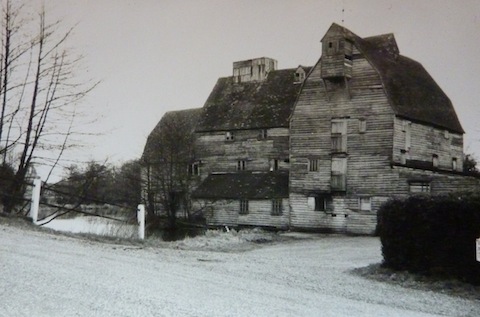
Where was this wooden mill on the River Wey Navigation?
This lovely old wooden mill no longer stands. It is a bit of a way out, several miles downstream on the River Wey Navigation from Guildford town. But was once a handsome landmark. Does anyone remember it and can say how and when it disappeared?
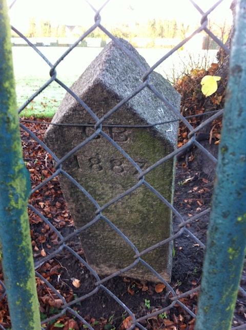
Where is this stone and what does it mark?
The quirky photo I imagine could be a boundary stone – it is nothing like the later ones, a number of which can be seen around Guildford. Photographed through a fence, it is close to the town centre and you might be able to see an open space behind, that may afford a clue.
Does anyone know where it is and what it marks?
If you know the answers please leave a reply in the box below. All replies will be posted at about the same time next week, along with a new post with the answers to this week’s photos and the next pair of images.
Share This Post


Responses to Where Is This? No.146
Leave a Comment Please see our comments policy. All comments are moderated and may take time to appear. Full names, or at least initial and surname, must be given.

I'm living well for nothing at all! (See: No Trifling Matter: Magpie Trapped in Godalming Sainsbury’s)


Next stop, Debt Chasm! (See: We Should All Be Outraged About the Failure to Deal with Legacy Debt)


John Lomas
February 7, 2015 at 4:15 pm
Is the mill Bowers Mill off Clay Lane, Burpham?
I think the stone could be somewhere round the boundary of the cricket ground, the fence looks the same as the one bordering Woodbridge Raod, possibly the stone is somewhere along the path alongside the railway embankment, between Woodbridge Road and the river.
Chris Townsend
February 7, 2015 at 5:43 pm
The mill was at Newark, near the lock and the priory ruins, and I remember reading reports of the disastrous fire in December 1966.
Domesday Book mentioned a mill thereabouts, but the one pictured dated from the 17th century. The mill house survives.
Much more info’ here:
http://www.weyriver.co.uk/theriver/wey_nav_4.htm
The boundary stone is alongside the cricket ground on Woodbridge Road, opposite the quirky gate at Boundary View.
The stone is marked, along with a number of others, on an O.S. map of 1895 which shows the Municipal Borough Boundary.
I wonder how many of the other stones could be found today?
Brian Holt
February 8, 2015 at 5:46 pm
This is Newark Mill, near Send. It was destroyed when the wooden building caught fire and was burned to the ground on the night of December 3,1966.
This stone is inside Woodbridge Road entrance to the cricket ground – you can see the scoreboard on the right in the picture.
Margaret Cole
February 10, 2015 at 9:19 am
This is Newark Mill near Ripley, burnt down in 1965, with nothing left of it.
It stood on the river left of the bridge and Newark House still stands.
It must have been magnificent to see. In the 1980 we did our outdoor summer painting in the area with Dick Carter from the adult education centre in Harvey Road: very good times. The local hostelry was the Seven Bells: good grub.
I’ve given up on the boundary stone but will hazard a guess as to near the cricket ground entrance in Wharf Road.
Doug and Bill Staniforth
February 10, 2015 at 2:52 pm
The mill is Newark Mill near Pyrford as used in the 1961 film On the Fiddle which starred Shaun Connery before he became Rodger Moore.
It was closed down in 1943 following damage by enemy bombing and in 1966 it burnt down, probably caused by a backfiring speedboat.
The boundary stone is by the cricket ground in Woodbridge Road.