- Stay Connected

Socialize

 Abraham Lincoln
If given the truth, the people can be depended upon to meet any national crisis...
Abraham Lincoln
If given the truth, the people can be depended upon to meet any national crisis...

 Guildford news...
for Guildford people, brought to you by Guildford reporters - Guildford's own news service
Guildford news...
for Guildford people, brought to you by Guildford reporters - Guildford's own news service
Where Is This? No.151
Published on: 12 Mar, 2015
Updated on: 12 Mar, 2015
By David Rose
Builders merchants Angel, Son & Gray, on the corner of Onslow Street and Woodbridge Road, was last week’s mystery vintage photo and the quirky photo was of the building in Haydon Place on the corner with the Bars.
Sorry once again in that it appears that these have been featured before. I tracked back, bust must of missed them!
Not to worry, as I am sure many newer readers would not have seen them first time around?
Some good replies as always with interesting comments from Vic Moseley about other premises in Woodbridge Road and near Leapale Road.
Click here to see last week’s post and all the replies.
There are more pictures of Angels in my book Images of Guildford (co-written with Graham Collyer) and reader Neil Smith tells me he can add a lot more information about the firm. So, expect that soon.
Here are this week’s and I really hope they have not been featured here previously.
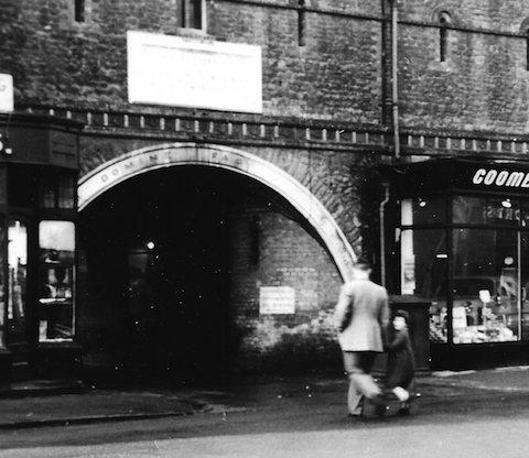
Where was this arch in Guildford town centre?
Here’s an archway I am sure many will remember. Do you know where it was and what became of it?
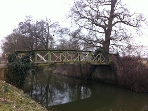
Where can this bridge be found?
This bridge can be regarded as a quirky feature as it kind of no longer leads to anywhere.
It’s on the Wey Navigation in the Guildford area. Do you exactly where and why it is no longer in use?
If you know the answers please leave a reply in the box below. All replies will be posted at about the same time next week, along with a new post with the answers to this week’s photos and the next pair of images.
Share This Post


Responses to Where Is This? No.151
Leave a Comment Please see our comments policy. All comments are moderated and may take time to appear. Full names, or at least initial and surname, must be given.

I'm living well for nothing at all! (See: No Trifling Matter: Magpie Trapped in Godalming Sainsbury’s)


Next stop, Debt Chasm! (See: We Should All Be Outraged About the Failure to Deal with Legacy Debt)


Dave Middleton
March 12, 2015 at 10:22 am
The building is the old Guildford Militia Barracks, once located on Friary Street at the junction with North Street, with a parade ground behind and backing on to the river. Sadly, now long demolished.
More detail can be found on the Queen’s Royal Surreys website at http://www.queensroyalsurreys.org.uk/depots/depots18.shtml
The bridge is on Bowers Lane at Burpham and was once the route of the road from Burpham to Jacobs Well, before the “new” A3 cut through the route and the new bridge on Clay Lane was built.
John Lomas
March 13, 2015 at 7:03 pm
Is the footbridge where the old Horsham line crossed the navigation?
Used as a footpath and possibly cycle path at one time but possibly now diverting near Stonebridge.
Judy Oliver
March 14, 2015 at 12:24 pm
The archway was at the bottom of North Street, which led to a footbridge over the river and to the Farnham Road bus station, now a car park.
It was about where the entrance to Jamie’s Italian is now.
When I was a young girl my father used to work in a small hut just the other side of the archway as an engineer.
I learned to dance in the Alby John dance studio which was on the first floor over the arch. I believe when the building was first built it was for the military, hence the small windows.
Jim Allen
March 15, 2015 at 4:19 pm
Bowers Lane, Burpham, replaced by the Clay Lane Bridge. The route soon to be inundated with Slyfield traffic – if they can get through the flood water!
Chris Townsend
March 15, 2015 at 6:26 pm
The archway was once the entrance to the 2nd Royal Surrey Militia depot, built about 1854 and occupied by the Militia until 1876.
The photo looks to date from about the late 1950s, taken from the foot of North Street, with Friary Street off to the left.
Inside Friary Square, as it was then called, was a row of three-storey terraced houses on the left, once used by the Militia.
Straight ahead was a footbridge leading over the river to the Farnham Road bus station, while over to the right was the Onslow Street bus station.
The room above the arch housed the Alby John School of Dancing.
I’ve read that Plastic Coatings once had a home in Nissen huts in the Square. The stones of the archway are in Northumberland – likely to confuse future archaeologists.
Vic Moseley
March 16, 2015 at 2:30 pm
I think the photo maybe shows the bottom of North Street where you could walk through and over the river to Park Street.
Doug and Bill Staniforth
March 16, 2015 at 2:33 pm
Picture 1 is the arch that used to stand at the bottom of North Street leading through to the footbridge to the Farnham Road bus station.
Above the arch was the Alby John School of Dancing and to the right was Coombs car showroom.
To the left we think there was an antique shop called Buyers and Fogwills corn and seed Merchants.
The arch was demomolished to make way for the awful buildings there now (New Look and Jamie’s Italian, formerly Midland Bank).
Picture 2 is the old Clay Lane bridge in Burpham, no longer in use due to the new road system.
Why oh why does the editor keep teasing us with picture after picture of river scenes without a speedboat in sight?
Sheila Atkinson
March 16, 2015 at 4:38 pm
There is no mistaking Friary Arch, it led from North Street into Friary Square.
Above the archway was Alby John School of Dancing, where I started learning ballroom dancing in 1959.
I still enjoy dancing to this day, but sadly there aren’t many places that cater for ballroom dancing in Guildford now.
Gill Jackson
March 17, 2015 at 9:55 am
I believe this was called Friary Arch. You walked through and over the river to the Farnham Road bus station.
To the right of the two people in the photo was the Onslow Street bus station.
Above the arch was a hall where I think was Albie John who ran ballroom dancing lessons, which I attended in the early 1960s.
It was in the area at the end of Friary Street – bottom of North Street.
I think the HSBC Bank was built there, although not sure if it’s still there as I moved from Guildford 12 years ago.
In the back of my mind I seem to remember it was originally a garrison/barracks.
Margaret Cole
March 17, 2015 at 2:26 pm
This was the archway from the bottom of North Street to the river bridge, leading to the Farnham Road bus station back in the 1950s.
It was once the entrance to the militia barracks when it was Friary Square, after which Plastic Coatings started business there in a Nissan hut.
Alby Johns Dance School was in part of the old barracks.
The bridge over the river is Bowers Bridge in Bowers Lane, off of Clay Lane, Burpham. About the time the new section of the A3 was built it became redundant, probably because it was too narrow.
Linda Jackson
March 17, 2015 at 8:48 pm
The first photo is of the old barracks arch at the bottom of North Street.
I was built in 1850s.
As a girl in the 1960s I would walk through it often when catching a bus at the Farnham Road bus station. It was demolished in the seventies.
I remember looking in the antique shop which was on the left of the arch. There was a car place to the right of the arch.
Today Tk Max occupy the site, the alleyway beside it is where the barrack arch stood.
John Thorp
March 18, 2015 at 6:35 pm
The arch was at the bottom of North Street and led down to the river where there was a footbridge across to the Park Street bus station, mainly used by Aldershot and District buses (or ‘have a shot and risk it’ as it was popularly called).
I seem to remember that the arch had a military connection possibly the entrance to a barracks.
The shop to the left of the arch was Fogwills, seed merchants and iron mongers, and it had a wonderful smell inside, of seed, animal foods and fertiliser. That mixture of smells always transports me back to that shop.
Dave Middleton
March 24, 2015 at 1:18 pm
The inscription in Latin on the arch reads,”Salvam Domine Fae Vietoriam” which translates to “0 Lord Save Victoria”.
I expect that it related to Queen Victoria, not the railway station in London!
James Dix
March 25, 2015 at 5:23 pm
Sorry I missed this one the first time around!
Definitely in my area of interest. Guildford Militia Barracks was also home to the Guildford company of 2nd Volunteer Battlion The Queen’s (Royal West Surrey) Regiment, or ‘The Surrey Rifles’ as they were generally known.
From the 1860s through to the late 1890s, They trained there around once a week and if the barracks was unavailable for some reason they would train in the grounds of the Royal Grammar School up the road.
There is a great deal more information about the barracks itself on the Regimental Museum Website and information about the rifle volunteers can be found on Our Website.
Stuart Levett
October 17, 2018 at 11:34 am
It took me back a bit seeing the photo of the militia barracks archway at the bottom of North Street. I was beginning to think it was all in my imagination.
Having lived in Haslemere, I remember on a Saturday we would either catch the train or get the “have a shot and risk it” bus to Guildford. I remember walking across the river bridge and there was a snack bar in the square, which we used at times. I was always trying to find out what this building was. I just stumbled across your article today. I am 70 years old now, so I took a while. Many thanks.