- Stay Connected

Socialize

 Abraham Lincoln
If given the truth, the people can be depended upon to meet any national crisis...
Abraham Lincoln
If given the truth, the people can be depended upon to meet any national crisis...

 Guildford news...
for Guildford people, brought to you by Guildford reporters - Guildford's own news service
Guildford news...
for Guildford people, brought to you by Guildford reporters - Guildford's own news service
Where Is This? No.135
Published on: 12 Nov, 2014
Updated on: 12 Nov, 2014
By David Rose
Many once again correctly identified last week’s mystery vintage photo as being the St Luke’s Hospital site, with the Alexandra Laundry in the background.
The photo shows the demolition of what were buildings of the former Guildford Union workhouse.
The quirky photo shows a plaque at St Nicolas Church, bottom of the High Street.
Click here to read last week’s post and the replies at the foot of it. My thanks go to Chris Townsend and Margaret Cole who supplied details of what the plaque commemorates – the death of rector Dr John Mosdell in 1875.
The Stanniforth brothers in their cryptic reply ask for a speedboat for Christmas as a prize. Maybe, who knows?
Here is this week’s mystery vintage photo.
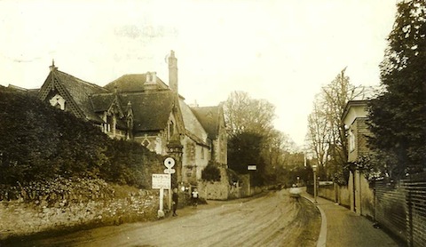
Do you recognise this stretch of road and the building seen to the left?
It is a main road a little less than a mile from Guildford town centre. The somewhat Gothic-looking building on the left still stands. I think it might have been a place of education at some time. The buildings seen on the right have gone, with newer residential development there now.
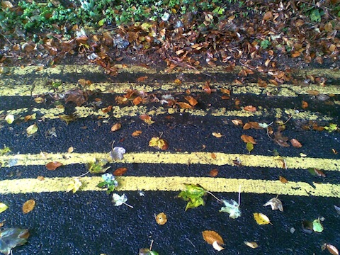
Where can these five yellow lines be found?
The quirky picture really is just that – five yellow lines! What’s the parking rule for those?
A bit hard to identify, unless you instantly know. However, I can say these lines are by a turning space not far from where an “old road” ends to vehicular traffic, and of which a part of it has been a byway of dispute in recent years – all to do with some “garden grabbing” development and a row over access.
If you know the answers, please leave a reply in the box below. Replies and the answers, along with two more mystery images will be published at about the same time next week.
Share This Post


Responses to Where Is This? No.135
Leave a Comment Please see our comments policy. All comments are moderated and may take time to appear. Full names, or at least initial and surname, must be given.

I'm living well for nothing at all! (See: No Trifling Matter: Magpie Trapped in Godalming Sainsbury’s)


Next stop, Debt Chasm! (See: We Should All Be Outraged About the Failure to Deal with Legacy Debt)


Bernard Parke
November 13, 2014 at 9:19 am
Portsmouth Road looking towards Guildford opposite Hitherbury Close.
John Lomas
November 13, 2014 at 2:25 pm
I think that the old photo is Portsmouth Rd with the infants school on the left (St Catherines School House) and a house called The Lawn opposite it.
margaret cole
November 17, 2014 at 11:10 pm
This is St Nicolas infant school, Portsmouth Road, dated about 1910.
The entrance to it now is up the Mount, less dangerous than the main road.
Of course if you go a little further up you’d see the yellow road markings outside the cemetery.
Doug and Bill
November 18, 2014 at 5:20 pm
The first pic is on the Portsmouth Road opposite Devon Bank near where Clarks College was. The yellow lines are in Dearbarn Road, it is said the extra lines were painted as practise for plimsol lines.
Chris Townsend
November 18, 2014 at 5:59 pm
The mystery building is St Catherine’s School, opposite Devon Bank on the Portsmouth Road.
When built in 1860, it served as the infant school for St Nicolas, with a schoolhouse adjoining, until about 1932.
It was next to the rectory, Rookwood, (where Rookwood Court is today), then on the town side was St Nicolas School, built in 1851 as a National School (mixed), which still exists today as an infant school.
The five yellow lines are at the top of The Mount, near the gates to the New Cemetery.
Margaret Cole
November 25, 2014 at 12:44 pm
Not too sure on the High Street windows, but I hazard a guess at Marks & Spencer, who took over the site of White’s department store.
The scaffolding is the finishing of Guildford Cathedral circa 1961.