- Stay Connected

Socialize

 Abraham Lincoln
If given the truth, the people can be depended upon to meet any national crisis...
Abraham Lincoln
If given the truth, the people can be depended upon to meet any national crisis...

 Guildford news...
for Guildford people, brought to you by Guildford reporters - Guildford's own news service
Guildford news...
for Guildford people, brought to you by Guildford reporters - Guildford's own news service
Where Is This? No.138
Published on: 4 Dec, 2014
Updated on: 4 Dec, 2014
By David Rose
No problems for all those who replied in correctly identifying last week’s mystery pictures.
St Catherine’s Chapel was the mystery vintage photo and a part of Guildford Museum being featured in the quirky photo.
Straight on to the next pair of pictures.
Do you know where this is?
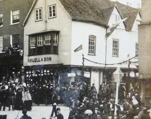
The vintage view I have cropped from a photo taken in about 1900 with lots of people attending some sort of event – not sure what it was. The picture is from the archives at the Guildford Institute.
I think that although the building featured, and the ‘corner’ where it is, is very well known, it might not be that obvious. We shall see.
Above which part of Guildford was this taken from and what can be seen?
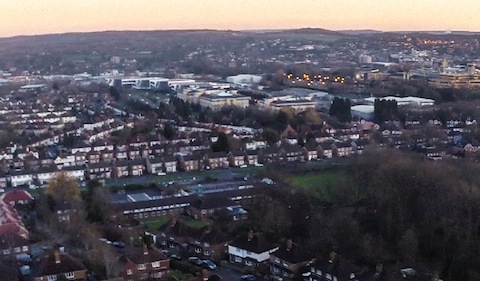
The quirky photo was taken by Dan James using his remote-controlled drone mini helicopter. Any ideas where he was flying it from and which group of buildings can been in the middle of the image? A business park, to give you a clue.
If you know the answers and can perhaps add some details, please leave a reply in the box below. Replies and the answers, along with two more mystery images will be published at about the same time next week.
Share This Post


Responses to Where Is This? No.138
Leave a Comment Please see our comments policy. All comments are moderated and may take time to appear. Full names, or at least initial and surname, must be given.

I'm living well for nothing at all! (See: No Trifling Matter: Magpie Trapped in Godalming Sainsbury’s)


Next stop, Debt Chasm! (See: We Should All Be Outraged About the Failure to Deal with Legacy Debt)


John Lomas
December 4, 2014 at 9:43 am
Quirky picture: Woodside Rd centre foreground, Willows Primary School above it, then the curving line of Midleton Road. Above that Guildford Business Park on the old Dennis Bros site. The orange/yellow dots are probably the lighting for the car park on the north side of Stag Hill with the University of Surrey buildings to the right.
The highest ground above the street lights should therefore be St Martha’s.
The camera drone is probably above the allotments or the hospital staff park and ride, just off Westway.
The old picture is the junction of Quarry Street and High Street. This building is now occupied by Thomas Cook, which is where they can sell cruises to your correspondents thus removing their need for a speedboat.
Alan Cooper
December 5, 2014 at 1:28 am
Looks like the corner of Quarry Street and High street, where WH Smith was in 1960s.
Vic Moseley
December 5, 2014 at 10:59 am
I am not too sure about this photo but I think it is the corner of Market Street and High Street Guildford, with the Bulls Head public House on the opposite corner.
James Dix
December 5, 2014 at 3:56 pm
The first photo I believe to be the corner of the High Street and Quarry Street – both buildings shown are now travel agents.
Assuming the date is around 1900, the two occasions that immediately spring to mind are the coronation of Edward VII and the parade for the return of the West Surrey Regiment from the Boer War.
Terry Stevenson
December 7, 2014 at 10:24 pm
Guildford High Street at its junction with Quarry Street.
Guildford Business Park and Cathedral Hill Industrial Estate, with Southway, Beckingham Road, Grantley Road and Weston Road in the foreground.
margaret cole
December 9, 2014 at 2:18 pm
The first picture is on the corner of Quarry Street, might be a dispute between the church and the Star public house?
The view over Guildford takes in Midleton Road business estate with the grounds of the Royal Surrey County Hospital in the forefront. I might be wrong.
Doug and Bill Staniforth
December 9, 2014 at 3:50 pm
1. It’s the corner of High Street and Quarrie Street. It used to be HW Smith (when they only sold books and did not force customers to buy chocolate oranges),it is now Thomas Cook.
2. We reckon this was taken above Woodside/Hillspur Road looking toward Guildford Business Park. In the foreground is St Francis Centre formerly Westborough School, Southway, which once had elm trees along one side.
The business park used to be Dennis Bros factory, who to the best of our knowledge did not manufacture speedboats or indeed caravans.
We wonder whether Dan James’ helicopter was one of Bullseye’s special prizes?
[Ed: Please note we continue to reproduce the Chuckle Brothers’ sometimes unique and quaint spellings and their deliberate play on names within their replies. This does not mean that they will be excluded for a major prize come the day that it is awarded. Shame the Alexander Dennis, coach and bus manufacturer based in Slyfield, does not make speedboats or caravans!]
Chris Townsend
December 9, 2014 at 5:55 pm
The shop on the corner of High Street and Quarry Street was also featured in Where Is This? No.42. Arthur Angell, outfitter, had had businesses in Basingstoke, Alton and Aldershot, and since about 1860 at 104 High Street, Guildford.
It was listed in directories as Angell and Baker, a partnership with Stephen Baker, then Arthur Jnr became a partner, and after him Henry Thomas Angell ran the business. He died in 1916.
The photo shows bunting hung across Quarry Street, but the flags outside the shop are a mystery to me.
The quirky photo was taken from Westborough, and shows the business park on the former Dennis’s site, with the town centre in the distance, top right.
The triangle of streets is made up of Grantley Road, Weston Road and Beckingham Road across the centre.
The red roofs of the school off Southway are on the left, and St Francis Church is just visible near the centre, at the junction with Weston Road. That’s Woodside Road in the foreground, with Hillspur Road off to its left.
Sheila Shersby
December 9, 2014 at 8:37 pm
Is the old picture of the junction of Guildford High Street and Quarry Street?
Brian Holt
December 9, 2014 at 10:31 pm
(1) This shop was on the corner of High Street and Quarry Street. In the late 1940s and 50s, when I lived in Quarry Street, it was WH Smith. I went in there many times and the newspapers were inside the door on the right. There was a small upstairs floor. It’s now a Thomas Cook travel agents.
(2) I think the school near bottom of the picture may be the County School in Farnham Road, with the offices on the corner of Guildford Park Road. Where the lights are is Guildford station and the town centre on right at the top of the picture.
Linda Jackson
December 10, 2014 at 5:43 pm
The first photo is of what is now Thomas Cook on the corner of Quarry Street and High Street. Was it WH Smith before that?
Could the querky photo have been taken from Stag Hill? Maybe the industrial estate on the A3 is on the top right-hand side of the picture.
David Mowat
December 10, 2014 at 6:31 pm
The vintage view is of the building on the corner of the High Street and Quarry Street. Over the years it has a number of uses. At one time it was used by WH Smith. These days it is a Thomas Cook travel agency (and you may be able to book a quick cruise there).
The quirky photo appears to have been taken from overhead a park in Park Barn. The building in the foreground is the Willows School and the buildings in the middle of the image are the Guildford Business Park with the Cathedral Hill Industrial Estate nearby.