- Stay Connected

Socialize

 Abraham Lincoln
If given the truth, the people can be depended upon to meet any national crisis...
Abraham Lincoln
If given the truth, the people can be depended upon to meet any national crisis...

 Guildford news...
for Guildford people, brought to you by Guildford reporters - Guildford's own news service
Guildford news...
for Guildford people, brought to you by Guildford reporters - Guildford's own news service
Where Is This? No.153
Published on: 25 Mar, 2015
Updated on: 25 Mar, 2015
By David Rose
Replies to last week’s mystery images were slow to come through at first – I thought that perhaps the pictures were too difficult.
Nevertheless, a number of people correctly identified the office block that once stood at the foot of Portsmouth Road.
It was offices of the Central Electricity Generating Board (CEGB) and reader Mark Knight pointed out that it was specifically occupied by the Transmission Project Group / Transmission Division of the CEGB. Thanks for that.
They may have been doing some secret research into electric speedboats (as suggested by the Stanniforth brothers), but that’s not a good enough suggestion to win you that long-awaited prize in this weekly quiz!
Several readers noted that the plot, which has stood empty for many years, is called the Guildford Plaza (not to be confused with the entertainment venue of that name that was in Onslow Street!)
Here at the Guildford Dragon NEWS we have no idea when it will ever be developed, as asked by the Stanniforth brothers. Linda Jackson notes that a for sale sign has now gone up.
The trees and bushes (a good deal of buddleia) that have grown up must make it a bit of a wildlife haven. I have mused that it could be developed with flats or starter homes along with some carefully designed green space. But neither am I a planner or a developer. Or it could be transformed into a great big block of apartments to the same height as the former CEBG building!
Previous to that it was the site of two breweries, both dating back to the 19th century – the Cannon and the Castle Breweries that later merged. But that’s another story!
The quirky picture proved a difficult one. It is a building that can be found within Guildford Borough Council’s Woking Road Depot. And I think it was once part of the town’s dust destructor – they call them incinerators today. It was opened in about 1910 and was in operation until around the 1950s and was where Guildford’s waste was burnt. Then, landfill was started up once more on an area of waste land that is now part of the Slyfield Industrial Estate.
Click here to see last week’s post and all the replies at the foot of it.
Here are this week’s images.
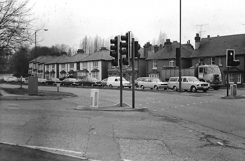
Where is this then?
Who recalls this row of house on the side of a busy road? It’s much changed here, but there are still traffic lights.
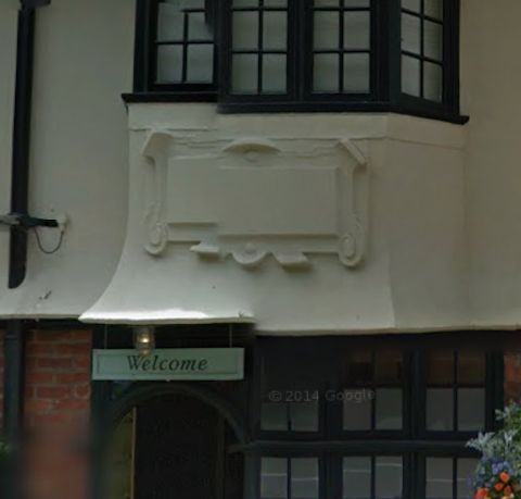
Do you recognise this building?
And the quirky photo is a part of what is surely a well known building – the name has changed and that’s why there is now no lettering on the moulded plaque. Do you know where it is?
If you know the answers please leave a reply in the box below. All replies will be posted at about the same time next week, along with a new post with the answers to this week’s photos and the next pair of images.
Share This Post


Responses to Where Is This? No.153
Leave a Comment Please see our comments policy. All comments are moderated and may take time to appear. Full names, or at least initial and surname, must be given.

I'm living well for nothing at all! (See: No Trifling Matter: Magpie Trapped in Godalming Sainsbury’s)


Next stop, Debt Chasm! (See: We Should All Be Outraged About the Failure to Deal with Legacy Debt)


Dave Cooper
March 26, 2015 at 8:54 am
The row of houses were on the A3 at Midleton Road Guildford opposite Dennis Bros’ commercial vehicle factory.
Mike Melbourne
March 26, 2015 at 9:55 pm
1. The junction of Midleton Road was then on the corner of the Wooden Bridge pub. The traffic lights
are where Fox’s garage is at present.
An old school friend of mine used to live in one of those houses before they were demolished.
The road surface doesn’t look much better then.
2. I think it’s the Three Pigeons pub opposite Holy Trinity Church in Guildford High Street.
Ed Gardner
March 27, 2015 at 7:56 pm
I’m in two minds about the top photo, very probably both wrong. But judging by the dual carriage and the right-hand bend that was the old A3 with Dennis Bros on the left?
John Lomas
March 28, 2015 at 3:14 pm
The old photo is the junction of Midleton Road (the by-pass) with Woodbridge Hill to the right (see right turn filter on T/L in the centre of the main road). The road to the left would be the side entrance to Dennis Bros.
The houses are now either under the new by-pass or where the trees and bushes are separating the two roads.
The photographer has his/her back to the railway bridge.
It is a quite cleverly positioned photo avoiding showing the Wooden Bridge Pub car park.
John Lomas
March 28, 2015 at 3:35 pm
The quirky photo is the town end bay on the Quarry Street pub known variously as Jolly Farmer, Weyside Inn and Boatman.
Sue Bushell
March 28, 2015 at 9:49 pm
Is the first picture the A3 by the Wooden Bridge?
The second picture I think maybe the Three Pigeons pub at the top of the High Street.
David and Ann Bailey
March 29, 2015 at 4:17 pm
The old Jolly Farmer pub in Quarry Street is now called the Weyside.
The houses were along the Midleton Road, near the Wooden Bridge public house. A childhood friend Chis Hopper lived in one of the cottages and we would sit on his fence to watch the summer weekend traffic jams. Great fun for us, not so good for the cars returning home after a trip to the coast.
Chris Townsend
March 29, 2015 at 4:39 pm
The row of houses (since demolished) was on Midleton Road, once part of the bypass opposite Dennis Bros. The turning on the left by the railway bridge (behind the photographer) once led to the Guildford Isolation Hospital, alongside the railway line. I remember it was used as council flats in the 1950s. The area in the photo is now part of the road system at Dennis’s roundabout.
The quirky photo shows the entrance to the Boatman, (or is it the Weyside?) formerly the Jolly Farmer, on Millbrook. The centre plaque of three still has the date 1913.
Ray Springer
March 30, 2015 at 8:13 pm
Midleton Road, the old A3 near the junction with Woodbridge Hill.
The quirky picture is the Weyside inn in Millbrook, once the Jolly Farmer and the Boatman, riverside pub.
Brian Holt
March 30, 2015 at 9:34 pm
1. These houses were in Midleton Road. The house on the right stood next to the Wooden Bridge pub.
On Sunday evenings in the summer crowds gathered from 7pm to watch the traffic. We went every week. Some sat on the Wooden Bridge car park wall. There was always the same two voluntary Surrey Constabulary Special Police Officers controlling the traffic at this junction. It was amazing, despite all the heavy traffic, they always got emergency vehicles answering calls through easy. The Wooden Bridge pub was the half way stop for Smith’s of Reading Coaches, and was full of their blue and orange vehicles.
2. The Jolly Farmer pub address was 31 Quarry Street. my family lived at 29a, and there was five houses between us that were numbered one to five. In the 1940s and 50s the Noble family ran the pub.
More recently it changed its name to the Boatman and then the Weyside.
Earlier in 1913 changes were made to the front of the pub.
Doug and Bill Staniforth
March 31, 2015 at 4:50 pm
It’s Midleton Road and the Midleton Road Industrial Estate road junction (Hospital Hill). The houses were demolished in the mid 1970s to make way for the A3 improvements.
The quirky photo is of the Wayside pub (formerly the Jolly Farmer) near Leroy’s (speed) boatyard.
[David Rose: First time I have herd the term Hospital Hill. Must refer to the Guildford Isolation Hospital that was once there. Like the speedboat hint with Leroy’s boathouse].
Martyn Pryce
March 31, 2015 at 11:31 pm
Is the first one Ladymead / Woodbridge Hill / Weyside Road junction where PC World is now?
Second one, is the three pigeons pub at top of High Street?
Carol Norris
April 1, 2015 at 11:00 am
Picture 1: May I add that before the CEGB and after the breweries on this site this was my father’s company, Guildford Glass & Metal Works.
Margaret Cole
April 1, 2015 at 6:22 pm
Picture 1: Midleton Road from the Wooden Bridge to Deerbarn Road, until they connected up the A3 to the Portsmouth Road demolishing all the houses and some, in view.
Picture 2: The Weyside, otherwise the Jolly Farmer, Millbrook. On the facade was written 1913 probably the date of build.
Pity about the car park, now a seating area and garden. Best hanging baskets around. I suppose we can’t have everything.
Peter Tribe
April 6, 2015 at 9:55 pm
These pictures should be called “Where was this?” not Where is this?…………………Pip Pip – A grammarian
[David Rose: Well, you may be correct. However, the title is used in a loose sense, and of course the ‘quirky’ picture featured each week is of somewhere or something that can be seen now. With 154 of these weekly columns published and counting, I see no need to change. And especially as the column is one of the most eagerly awaited each week and one of the most well read on The Guildford Dragon NEWS.]
Robin Lawton
September 27, 2016 at 7:32 pm
This is most interesting! I used to sell classic and vintage cars from the old Martins garage at the bottom of Quarry Street, from about 1973 until I moved up to Barrack Roadd in Stoughton in 1987.
I recall the floods in 1968 too!