- Stay Connected

Socialize

 Abraham Lincoln
If given the truth, the people can be depended upon to meet any national crisis...
Abraham Lincoln
If given the truth, the people can be depended upon to meet any national crisis...

 Guildford news...
for Guildford people, brought to you by Guildford reporters - Guildford's own news service
Guildford news...
for Guildford people, brought to you by Guildford reporters - Guildford's own news service
Where Is This? No.157
Published on: 23 Apr, 2015
Updated on: 23 Apr, 2015
By David Rose
Well done to those who were spot with identifying last week’s images.
The vintage aerial view showed various buildings and features including Billings print works in Walnut Close and the London Country bus garage in Leas Road.
Click here to see last week’s post and all the replies – further buildings were named by some of those who replied with some interesting recollections from Linda Jackson of the 1968 floods that affected houses in Walnut Tree Close. Thanks for those.
Last week’s quirky picture showed a part of the Alexander Dennis factory on the Slyfield Industrial Estate, again a number of readers worked out what it was.
What do we have here then?
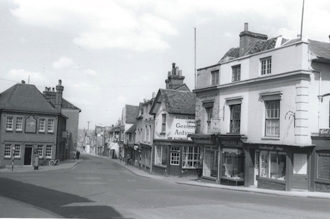
This week’s vintage picture is a town centre street scene that dates to the late 1940s. It should be familiar to many, although several of the buildings seen in it no longer stand. Do you recognise it? Can you add any information about what’s in view?
Where can this coat of arms be found?
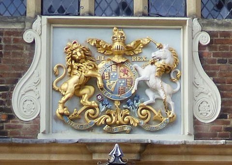
The quirky photo features a handsome coat of arms on a well known town centre building dating back to the first quarter of the 17th century. Do you know where it is?
If you know the answers please leave a reply in the box below. All replies will be posted at about the same time next week, along with a new post with the answers to this week’s photos and the next pair of images.
Share This Post


Responses to Where Is This? No.157
Leave a Comment Please see our comments policy. All comments are moderated and may take time to appear. Full names, or at least initial and surname, must be given.

I'm living well for nothing at all! (See: No Trifling Matter: Magpie Trapped in Godalming Sainsbury’s)


Next stop, Debt Chasm! (See: We Should All Be Outraged About the Failure to Deal with Legacy Debt)


Bernard Parke
April 23, 2015 at 9:03 am
North Street and Chertsey Street junction.
And Abbot’s Hospital.
Chaz Folkes
April 23, 2015 at 11:06 am
The first image is the junction of Chertsey Street with North Street. The building housing Eagle Radio now sits on the right hand side of the view.
The second picture is taken outside the Abbot’s Hospital on High Street.
Carol Norris
April 23, 2015 at 1:46 pm
Picture 1 : Might be Chertsey Street on the right side with Gillingham’s Antique Shop. North Street on the left. Shows where the two streets join before the junction with High Street.
Picture 2 : Abbot’s Hospital.
John Lomas
April 24, 2015 at 9:38 am
The black and white picture is the junction of Chertsey Street with North Street, the photographer probably stood just outside what is now the post office.
The coat of arms is on the High Street fascia of Abbot’s Hospital.
Ray Springer
April 25, 2015 at 9:16 pm
The junction of Chertsey Street and North Street.
On the left is the Dolphin public house, demolished in 1964 and currently a restaurant/pub, TGI Friday, etc.
Beyond the pub is a building, still standing, which was the labour exchange (Ministry of Labour) now called “Guildford Workmen’s Home and Coffee House”, although I think it has always been this.
On the opposite side of the road, Chertsey Street, is the entrance to Pannell’s Court. Surprisingly, the buildings here are still there today, although many changes have been made over the years.
The quirky picture is the front entrance to Abbot’s Hospital in the High Street.
Doug and Will Staniforth
April 28, 2015 at 4:35 pm
It’s the top of North Street with Chertsey Street on the right, the building on the left is the Dolphin pub.
Legend tells of a curse the landlord left on the property when it was closed (probably because the compensation wasn’t enough to buy a speedboat).
[Ed: It would seem that delusional dreams of speedboats is a common problem amongst business owners in the area.]
The coat of arms are on Frankie Abbot’s Hospital.
[Ed: Frankie Abbott indeed! Wasn’t he a character in the 1970s TV comedy Please Sir?]
Chris Townsend
April 28, 2015 at 6:00 pm
The street in view is Chertsey Street, with the Dolphin pub on the corner. To the right was one of Percy Gillingham’s enterprises, an antique shop, beside an alleyway once called Smart’s Gateway. Down the alley, behind the Chertsey Street shops, was Pannell’s Terrace, a long row of cottages demolished in the early 1960s.
Gillingham’s furnishings shop occupied the left-hand part of the large building on the right. That part once housed the Golden Lion, a beerhouse which was closed about 1906, after its licence was not renewed; under the terms of the 1904 Licensing Act, the pub was not considered to be necessary, and compensation of £524 was paid to the owners, the Reffell brothers of Gomshall, brewers, while the licensee received £26.
The royal arms are above the central entrance doors to Abbot’s Hospital. The letters “J I” indicate the reign of James the first. I’ve read in the Victoria County History of Surrey (1911) of an inscription “These arms erected by S. Robinson, master 18(25).” Are those words visible today?
Margaret Cole
April 29, 2015 at 8:47 am
The vintage picture is Chertsey Street, with the Dolphin pub on the left and Gillingham Antiques opposite, this used to be on the corner of Pannells Terrace, now Pannells Court.
I don’t know when the street named changed, perhaps someone will know.
In Gillinghams shop window there used to be an old table half French polished and the other half untouched with a tin of beeswax there. Always intrigued me how to do it. Of course I did have a go, not easy.
The coat of arms is above Abbot’s Hospital in the High Street.
Linda Jackson
April 29, 2015 at 3:10 pm
1. This photo is of the Dolphin pub which was on the corner where North Street meets Chertsey Street which was demolished and it is now TFI Fridays.
The buildings opposite are still there, the shop on the corner of Pannells Court is now an estate agents. The buildings on the right are no longer there and maybe demolished in the 1960s. Ryman’s is there now.
2. This photo is of the front of the Abbot’s Hospital in the High Street.
Paul Woods
October 17, 2016 at 2:20 pm
Can anyone say where in the High Street the Board of Trade had its “Labour Exchange” and when?
Bernard Parke
October 17, 2016 at 9:10 pm
The Labour Exchange was at the High Street end of Chertsey Street on the left side as you went down the street