 Abraham Lincoln
If given the truth, the people can be depended upon to meet any national crisis...
 Guildford news...
for Guildford people, brought to you by Guildford reporters - Guildford's own news service
Where Is This? No.164
Published on: 10 Jun, 2015
Updated on: 10 Jun, 2015
By David Rose
Onslow Street with an Aldershot & District bus was last week’s mystery vintage image. Many correctly identified it and added comments about the buildings seen in the photo and businesses once there.
Click here to see last week’s post and all the replies at the foot of it.
The quirky picture showed a piece of carved woodwork on a building currently occupied by an estate agents in Quarry Street on the corner of Mill Lane.
In her reply, Chris Townsend notes that the feature is actually known as a dragon post. Well, there you go!
Well done and thanks to all who replied.
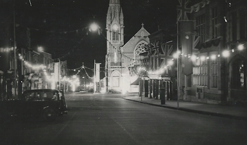
This week’s mystery vintage picture is a Guildford street scene taken at night (which might make identification a bit trickier). I think it dates to George VI’s coronation in 1937, hence the flags and lights.
A clue for anyone who needs one is that the church was pulled down in the early 1970s.
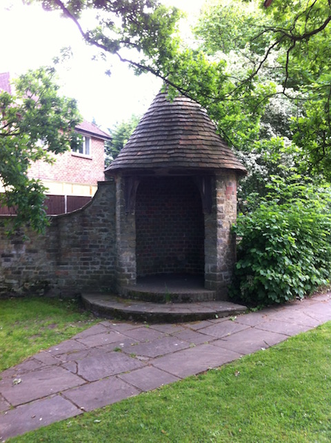
The ‘quirky’ picture shows some kind of shelter – but I’ve never seen anyone in there. It is, in fact, one of a pair. They can be found on a busy road about a mile to the north-east of the town centre.
If you know the answers and can perhaps add some extra facts, please leave a reply in the box below. They will be published at about this time next week along with two more mystery images.
Responses to Where Is This? No.164
Leave a Comment Cancel reply
Please see our comments policy. All comments are moderated and may take time to appear. Full names, or at least initial and surname, must be given.
Click on cartoon for Dragon story: Public Asked for Views on SCC’s Proposal for Reduced Speed Limits


Recent Articles
- Letter: Will GBC’s New Planning Document on Building Heights Be Effective?
- Proposed New Leisure Contract Should Improve Facilities and the Council’s Income
- Witness Appeal Following Fatal Collision
- Celebration at Guildford Cathedral of its Latest and Future Church Leaders
- Photo Feature: Now You See It…
- Letter: Snail-paced Progress for Full Weir Repair
- Mayor’s Diary: July 5 -July 20
- One Homeowner Recompensed but Fight Continues Over Waverley CIL Charges
- Letter: Fine Those Guilty of Anti Social Behaviour
- GBC Working Hard To Mitigate Looming Weyside Urban Village Deficit


Recent Comments
- Jan Messinger on Public Asked for Views on SCC’s Proposal for Reduced Speed Limits
- Fiona White on GBC Asks Residents for Views on Its Draft Building Height Guidance
- Dave Middleton on Letter: Fine Those Guilty of Anti Social Behaviour
- Carina Coverly on GBC Asks Residents for Views on Its Draft Building Height Guidance
- M Durant on Online Event Will ‘Help Residents Have Their Say On Local Government Reorganisation’
- Jim Allen on GBC Working Hard To Mitigate Looming Weyside Urban Village Deficit
Search in Site
Media Gallery
Dragon Interview: Local Artist Leaves Her Mark At One of England’s Most Historic Buildings
January 21, 2023 / No Comment / Read MoreDragon Interview: Lib Dem Planning Chair: ‘Current Policy Doesn’t Work for Local People’
January 19, 2023 / No Comment / Read MoreA3 Tunnel in Guildford ‘Necessary’ for New Homes, Says Guildford’s MP
January 10, 2023 / No Comment / Read More‘Madness’ for London Road Scheme to Go Ahead Against ‘Huge Opposition’, Says SCC Leader
January 6, 2023 / No Comment / Read MoreCouncillor’s Son Starts Campaign for More Consultation on North Street Plan
December 30, 2022 / No Comment / Read MoreCounty Council Climbs Down Over London Road Works – Further ‘Engagement’ Period Announced
December 14, 2022 / No Comment / Read MoreDragon Interview: GBC Reaction to the Government’s Expected Decision to Relax Housing Targets
December 7, 2022 / No Comment / Read MoreHow Can Our Town Centre Businesses Recover? Watch the Shop Front Debate
May 18, 2020 / No Comment / Read More


Alan Cooper
June 11, 2015 at 1:00 am
North Street with the junction of Woodbridge Road.
Bernard Parke
June 11, 2015 at 3:06 am
1) The Old Methodist Church in North Street, now Barclays bank.
2) Entrance to Ganghill on the London Road. It was said it was a meeting place for villians in the long distant past.
Chaz Folkes
June 11, 2015 at 8:28 am
The street is North Street, looking down towards the river and what is now the Friary. The site of the church now houses Barclays bank and Burger King.
The structure is one of a pair on the entrance to Gang Hill, a residential road off the London Road, just down from the roundabout at the tip of Stoke Park.
Teresa Bass
June 11, 2015 at 8:34 am
The vintage picture I think is looking down North Street. The church was demolished and the building became Barclays bank and CH Furniture.
The other picture is maybe one of the two structures on the London Road at the entrance to Ganghill.
John Lomas
June 11, 2015 at 9:43 am
The old picture appears to show North Street looking downhill towards the Methodist church (closed at that site in about 1966 even if it took until the 1970s to demolish it) on the corner of Woodbridge Road.
I
agree the illuminations and flags appear to be patriotic rather than seasonal could it actually be later, either 1953 for the Coronation or 1957 for the septuacentennial of Guildford’s Charter.
Ray Springer
June 11, 2015 at 4:58 pm
The view is North Street with the Methodist church on the corner of Woodbridge Road.
The old post office is on the right of the picture and another church, the Congregational is the other side of the post office, although not really clear on this picture.
The quirky picture is on the old A3 London Road at the entrance to Ganghill. Don’t know what these were, just shelters within the boundary wall
[Ed: And many happy returns to Ray on his recent 80th birthday!]
Chris Townsend
June 13, 2015 at 12:13 pm
The view is of North Street, with the Methodist Church on the corner of Woodbridge Road. On the opposite corner, going up the street, was a wool shop, next Pascall’s (for cycles, prams etc.) then Pullen’s greengrocer’s, and a tobacconist’s.
The main post office was the building beside the banner, and next to that the Congregational Halls.
The quirky shelters are at the entrance to Ganghill, a private road of 1930s houses, off the London Road.
Sheila Atkinson
June 16, 2015 at 1:46 pm
The main photo was taken in North Street and the church featuring prominently in the picture is the Methodist Church.
On the right hand side is the old post office and closer to the corner of Leapale Road is the Congregational Church. I met my husband at a dance in the Congregational Church Hall in 1963.
I think the unusual structures are on the Epsom Road.
Doug and Bill Staniforth
June 16, 2015 at 4:11 pm
Picture 1 is the old Methodist Church in North Street.
Picture 2 is the entrance of Ganghill from London Road.
These shelters are in fact where guards used to be on duty, before the advent of burglar alarms, looking after the residents, houses and property including many speedboats as this is a posh area!
[Ed: Nice try, but that won’t get a speedboat prize!]
Margaret Cole
June 17, 2015 at 7:30 am
This is North Street, looking down towards the Methodist church standing so magnificent on the corner of Woodbridge Road and the post office building on the right in North Street.
The brickwork shelters with the castlellated roofs can be found at the entrance to Daryngton Drive in Epsom Road, Merrow, built between the wars.