- Saturday, July 05, 2025
- Stay Connected

Socialize

 Abraham Lincoln
If given the truth, the people can be depended upon to meet any national crisis...
Abraham Lincoln
If given the truth, the people can be depended upon to meet any national crisis...

 Guildford news...
for Guildford people, brought to you by Guildford reporters - Guildford's own news service
Guildford news...
for Guildford people, brought to you by Guildford reporters - Guildford's own news service
Where Is This? No.181
Published on: 22 Oct, 2015
Updated on: 22 Oct, 2015
By David Rose
It was indeed Thomas Thorp’s bookshop in Constitution Hall at the top of the High Street featured as last week’s mystery vintage photo.
Many readers have fond memories of that wonderful shop as noted by those who replied.
Among its many delightful dusty corners was a great section on railways. Not sure about a section on speedboats as queried by Bill and Doug Stanniforth!
When I started at the Surrey Advertiser in 1978, one of the advertising managers by the name of Alan (think his surname was Redmond) spent many of his lunch breaks in Thorp’s hunting for old and rare books. He later left to start up in business as an antiquarian book seller. I wonder what became of him?
John Thorp (super chap) ran the shop in its later years and he is still around. I think he still works for the borough council at Millmead.
There were plans to site Guildford’s tourist information centre in Constitution Hall, but nothing came of it and I think Guildford Borough Council then sold the building.
For a while it was occupied by Dwell furnishings, but it seems that business went bust and it is now a clothes shop.
It’s worth having a look round, as upstairs you can get a feel of what it was like when it was used as a cinema.
The quirky photo of the phoenix can be found in the Pheonix Square shopping area between North Street and High Street.
Very interesting that Chris Townsend in her comment notes a date on the wall of 1889, when the Maidstone brewer Fremlin’s opened a depot there. I will have to go and have a look!
I do have a lovely picture of a line-up of Fremlin’s horse-drawn drays there (North Street end), so that puts it all into context of exactly where the depot was. As far as I know, Fremlin’s did not brew in Guildford. Just having a presence in the town must have been some annoyance to the Friary Brewery whose premises was not far away!
I read somewhere that the word ‘gremlins’ dates back to the Second World War and is attributed to RAF pilots who, while based in the Home Counties, drank Fremlin’s ales and gremlins became a corruption of the name. Can anyone add any further details?
Click here to see last week’s post and all the comments at the foot of it.
And so moving on to this week’s mysteries…
The vintage picture is from the collection of the late Dave Salmon and now entrusted to Geoff Burch of Worplesdon.
Dave’s memorial service at St Saviour’s Church on Friday last week, of which I played a part in the showing of his images, was very well attended. My thanks go to all who attended, Geoff and his wife Pauline for their hard work in organising it, Justin White of Repropoint, who kindly printed a large selection of Dave’s pictures that we displayed at the reception afterwards, and the clergy at the church for their lovely words during the service.
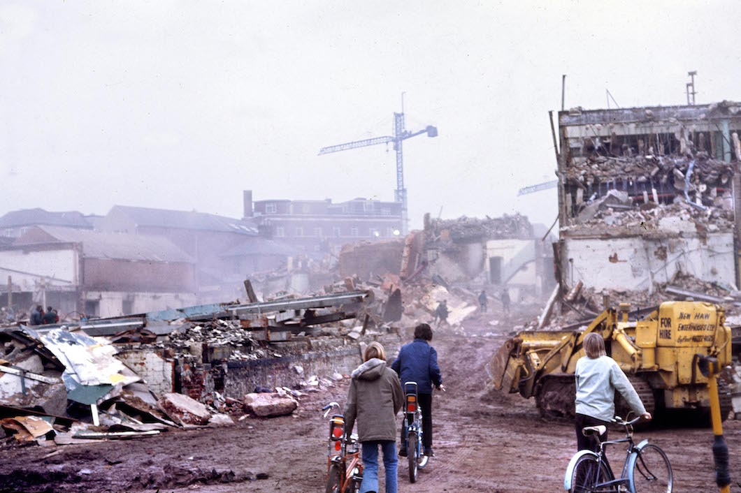
A photo of a Guildford demolition site in 1974. Do you know where? Picture by the late Dave Salmon. Click to enlarge in a new window.
So, this fantastic photo that Dave Salmon took in April 1974 shows a demolition site in the town centre. In the background you can see the telephone exchange in Leapale Road. That’s clue to the location.
Look at the young lads with their Chopper bikes walking through the site – health and safety wouldn’t allow that today!
Do you know what was coming down? Can you add some details? Another clue has been given already in this post.
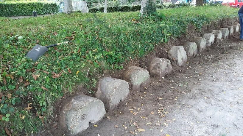
Do you know where these are beside the River Wey and what they were intended for? Picture by Richard Cant. Click to enlarge picture in a new window.
The quirky picture shows some concrete cylindrical blocks that have recently been better exposed by Richard Cant, one of the National Trust’s lengthsmen on the River Wey Navigation.
We think we know what they are, but do you? If you don’t know where they are, they’re not far from the National Trust’s Wey Navigation’s headquarters.
If you know the answers to this week’s mysteries and can perhaps add some extra facts, please leave a reply in the box below. They will be published at about the same time next week along with two more mystery images.
Share This Post


Responses to Where Is This? No.181
Leave a Comment
Please see our comments policy. All comments are moderated and may take time to appear. Full names, or at least initial and surname, must be given.
Click on cartoon for Dragon story: Public Asked for Views on SCC’s Proposal for Reduced Speed Limits


Andrew Backhurst
October 23, 2015 at 10:08 am
What a brilliant picture! It can only be the brewery and site of the current Friary Centre.
As a boy about the same age as the lads on the bikes I remember once the site was demolished and before building work started on the Friary there was a fair on the site.
Chris Townsend
October 25, 2015 at 4:05 pm
The 1974 photo shows the demolition of the Friary Brewery, viewed from the Onslow Street side of the site.
The concrete blocks are WW2 anti-tank roadblocks, only partially uncovered. The holes in the centre allowed them to be rolled into place on a bridge or road (at Woodbridge?) before being stood upright, presumably by using the ring visible in the block on the left in the photo.
Ray Springer
October 27, 2015 at 10:37 am
1974 – must be the demolition of the Friary Brewery buildings before the building of the Friary Centre.
Doug and Bill Stanniforth
October 27, 2015 at 3:10 pm
Picture 1 is the site of the Friary Brewery during demolition. Does anyone else agree that the brewery was preferable to a shopping centre?
Picture 2 is at Dapdune Wharf on the Wey.
The concrete blocks are obviously a trap for speedboats. These work incredibly well as is proved by total lack of these transportation items.
[Ed: well, well, you might have the answer there!]
BrianHolt
October 27, 2015 at 10:01 pm
Demolition of the Friary Brewery,
Antony Saunders
May 15, 2017 at 8:31 pm
The cylinders are, I believe, WW2 anti-tank obstacles, being cylinders this type of obstacle could be rolled to where they were to block a road and then levered onto their end. These seem to have been disposed of by burial.