- Stay Connected

Socialize

 Abraham Lincoln
If given the truth, the people can be depended upon to meet any national crisis...
Abraham Lincoln
If given the truth, the people can be depended upon to meet any national crisis...

 Guildford news...
for Guildford people, brought to you by Guildford reporters - Guildford's own news service
Guildford news...
for Guildford people, brought to you by Guildford reporters - Guildford's own news service
Where Is This? No.201
Published on: 17 Mar, 2016
Updated on: 17 Mar, 2016
By David Rose
Many readers correctly identified the part of the High Street were the setts were being repaired in last week’s mystery picture as being towards the top and near the Three Pigeons pub.
Some additional details were supplied, with Linda Jackson noting: “My great grandfather used to repair the setts on a Sunday in the 1930s and 40s. In those days if he was working up by Holy Trinity Church, the work would stop whilst the service was on. I think there was a hut for the taxi drivers nearby where they would crow or groan about the football results.”
There was indeed a wooden hut for taxi drivers just in front of Holy Trinity Church’s steps. That part of the High Street was once the town’s taxi rank – well certainly in the days when they were horse-drawn.
The wind vane in the quirky photo can be found on the top of the building that is now Jamie’s Italian Restaurant, formerly occupied by the Midland Bank.
Click here to see last week’s post and all the replies at the foot of it.
Thanks to all who replied. As a reminder, our policy is to include full names, so no nicknames or social media monikers please!
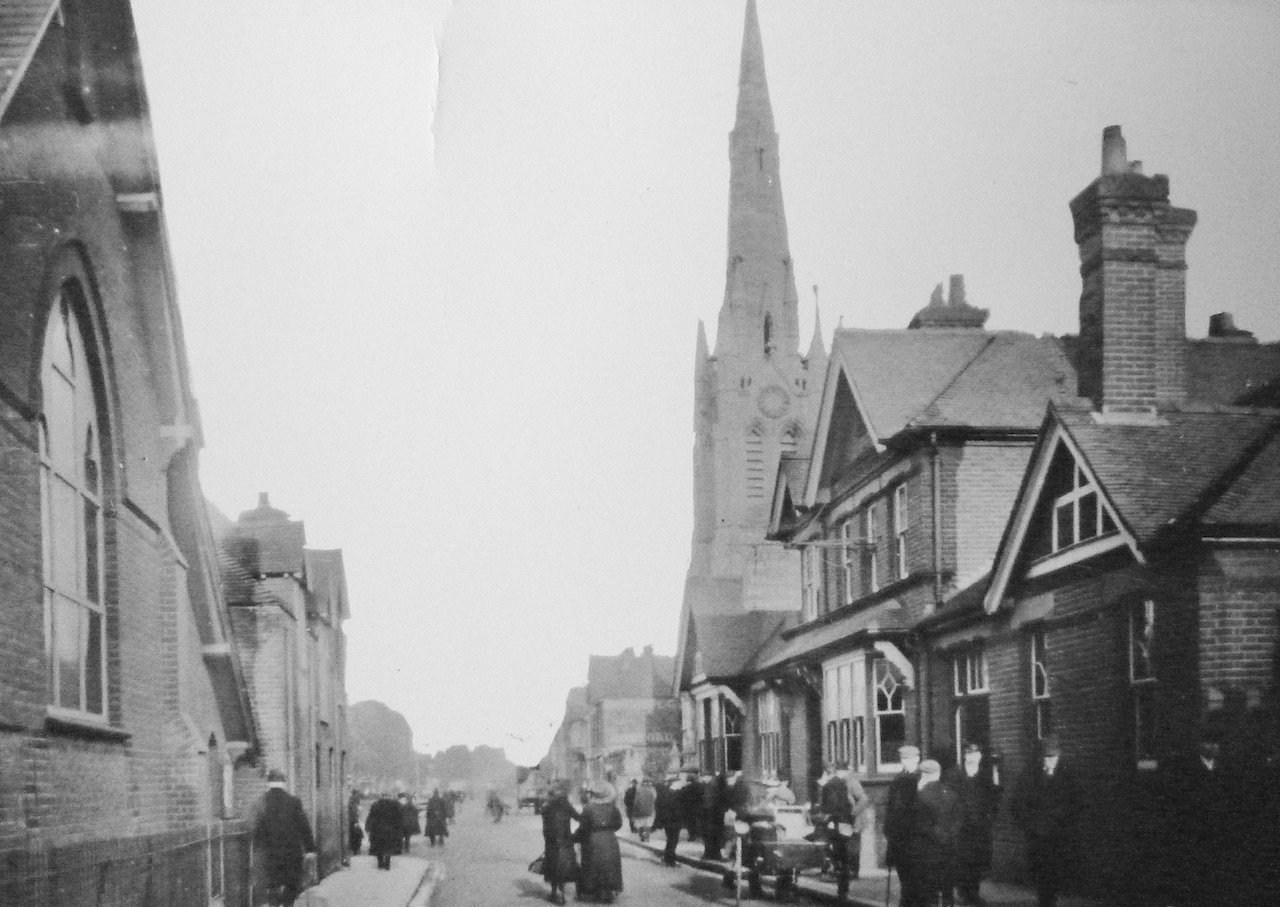
Do you recognise this Guildford street scene? Click to enlarge in a new window.
On to this week’s pair and the vintage picture is of dubious quality but it was issued as a picture postcard in the early part of the 20th century.
You may recognise the church, but much else has long gone. Can you say where it is and even what some of those buildings were?
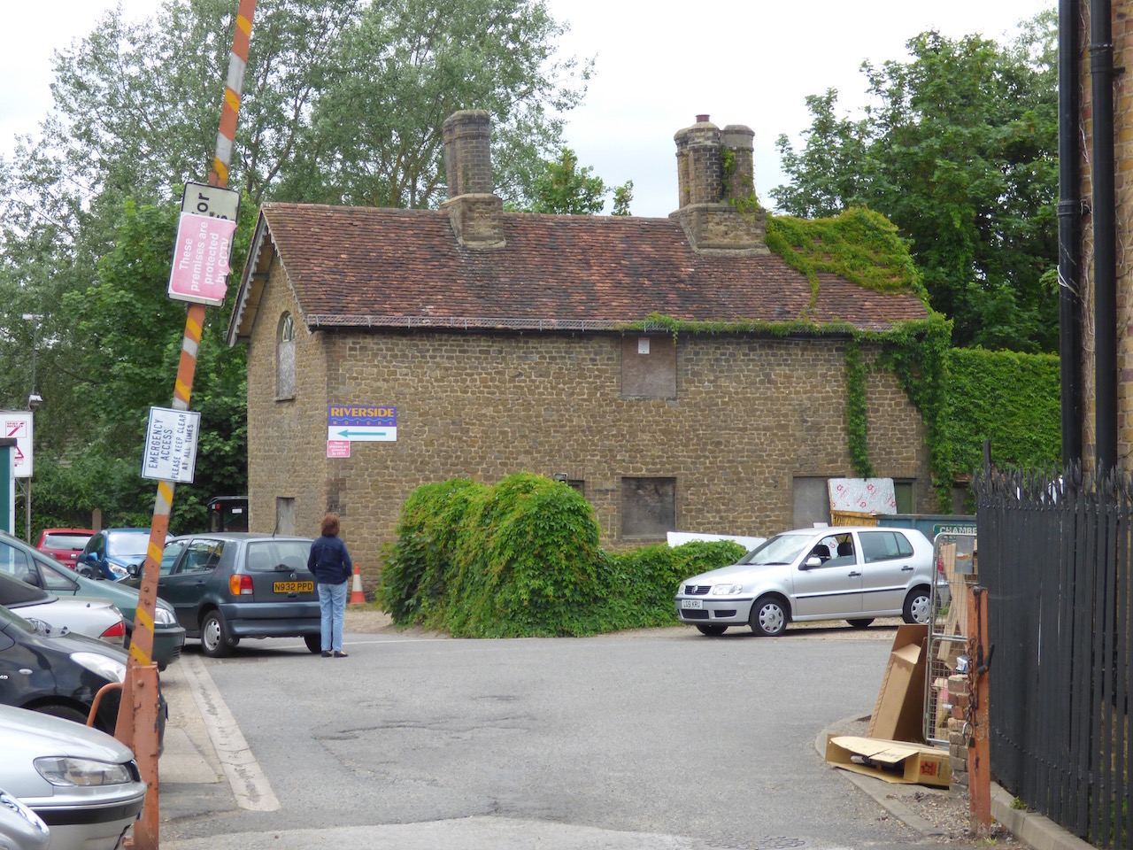
Where can this old cottage be found? Click to enlarge in a new window.
The quirky picture is a quaint bargate stone cottage that was under threat of demolition not so long ago, but I think plans for that were refused. As a clue, it’s near the river, not too far from the town centre. Any ideas?
If you know the answers to this week’s mysteries and can perhaps add some extra facts, please leave a reply in the box below. They will be published at about the same time next week along with two more mystery images.
Share This Post


Responses to Where Is This? No.201
Leave a Comment Please see our comments policy. All comments are moderated and may take time to appear. Full names, or at least initial and surname, must be given.

I'm living well for nothing at all! (See: No Trifling Matter: Magpie Trapped in Godalming Sainsbury’s)


Next stop, Debt Chasm! (See: We Should All Be Outraged About the Failure to Deal with Legacy Debt)


Bernard Parke
March 17, 2016 at 8:44 am
1) Prince of Wales on the right just before St Saviour’s Church. St Saviour’s Hall to the left.
2) Dapdune Wharf near Riverside Motors and Autologic.
John Lomas
March 17, 2016 at 11:17 am
The old picture shows Woodbridge Road and St Saviour’s Church.
On the left is the Parish Rooms and on the right a public house, probably the Prince of Wales demolished in 1972 for the road “improvements”.
The modern photo is obviously near a river but a guess only this week. Dapdune Wharf?
Aubrey Leahy
March 17, 2016 at 3:52 pm
The street scene shows a part of town associated with wonderful smells.
I used to cycle past there on my way to Mussels to do my paper round.
Lympos & Smee lactosian smells; then eau de breakfast fry-up from the cafe next to the bridge; sports ground smelling of fresh cut grass when a match was due; past the market (with country pongs on a Tuesday); along past Ayers bakery with bread and baking aromas; then past the Friary brewery for the hop and malting perfumed airs; up the High Street where the coffee roasters were at work and Astolat bakers made you even hungrier.
Seven and six bob a week plus a half-crown if you started your round by 6.45am every day. A breakfast before you left home and another before going to school.
Dave Middleton
March 17, 2016 at 6:50 pm
St Saviour’s Church, Woodbridge Road, looking north.
The cottage is tucked away at the end of William Road, backing onto the river near to Riverside Autos.
Jackie Kay
March 17, 2016 at 7:26 pm
Bottom of William Road next to the garage repair shops.
Ray Springer
March 17, 2016 at 9:55 pm
This is Woodbridge Road at the junction with Onslow Street. The church is St Saviour’s – about the only building in the picture that is still there.
The building on the right hand side is the Prince of Wales pub. One of the first pubs in Guildford I used, many years ago.
Much later this area was called Angel’s corner after Angel Son & Gray who had a builders’ merchants business there.
The quirky picture is a building at the end of William Road. I think it is now part of Martin Leigh Automobiles.
Chris Townsend
March 20, 2016 at 5:43 pm
The postcard view shows Woodbridge Road near its junction with Onslow Street.
On the left was St Saviour’s Hall, opened in 1892 as a temporary church before the present St Saviour’s was consecrated in 1899.
After 1960 the site was occupied by Angel, Son & Gray, ironmongers, and known as Angel’s Corner. On the right, next to the church, was the Prince of Wales pub.
The old cottage is Dapdune Farmhouse, at the end of William Road.
Now that plans for demolition have been refused, I hope this locally-listed building can be put to good use in the future, as it could be an attractive feature near the riverside.
Margaret Cole
March 22, 2016 at 4:15 pm
I believe the first picture shows the Prince of Wales pub in Woodbridge Road, with St Saviour’s church just behind.
Most probably a Tuesday with all the people around going to and from the market.
The second picture is at the far end of William Road showing Martin Leigh Automobiles, which was once Dapdune Farm.
Brian Holt
March 22, 2016 at 10:20 pm
The Prince of Wales pub, Woodbridge Road.
Built in 1893, it was a Watney’s house when it closed and demolish in 1972.
It was run by the Boyce family who had a catering business, and also had a shop just up the road at the end of Commercial Road.
The old cottage is by Dapdune Wharf.
Bill and Doug Staniforth
March 23, 2016 at 9:15 am
Picture 1 is Woodbridge Road looking north with St Saviour’s church on the right and the trees on the left by the cattle market, now the court buildings.
Is the man with the hand barrow Martin (Mick) Giles?
Picture 2 is William Road leading down to the river.
The clue is the sign Riverside Motors. We did wonder if this should read Riverside Motor Boats?