- Stay Connected

Socialize

 Abraham Lincoln
If given the truth, the people can be depended upon to meet any national crisis...
Abraham Lincoln
If given the truth, the people can be depended upon to meet any national crisis...

 Guildford news...
for Guildford people, brought to you by Guildford reporters - Guildford's own news service
Guildford news...
for Guildford people, brought to you by Guildford reporters - Guildford's own news service
Where Is This? No.223
Published on: 24 Aug, 2016
Updated on: 24 Aug, 2016
By David Rose
I’m calling time a bit earlier this week on the previous mysteries. Not so many replies as usual – perhaps people are away on holiday?
However, several readers correctly identified the vintage picture as being Pirbright with the village hall (Lord Pirbright’s Hall) in view.
The quirky photo of a piece of public art can be found on the edge of Queen Elizabeth Park, near Little Street. And the view showed Kirke Field in the background, once the playing field of Stoughton Barracks and now part of the Cardwells Keep development.
And Mike Williams noted there is a road sign in Pirbright written in French. Any ideas?
On to this week’s mysteries…
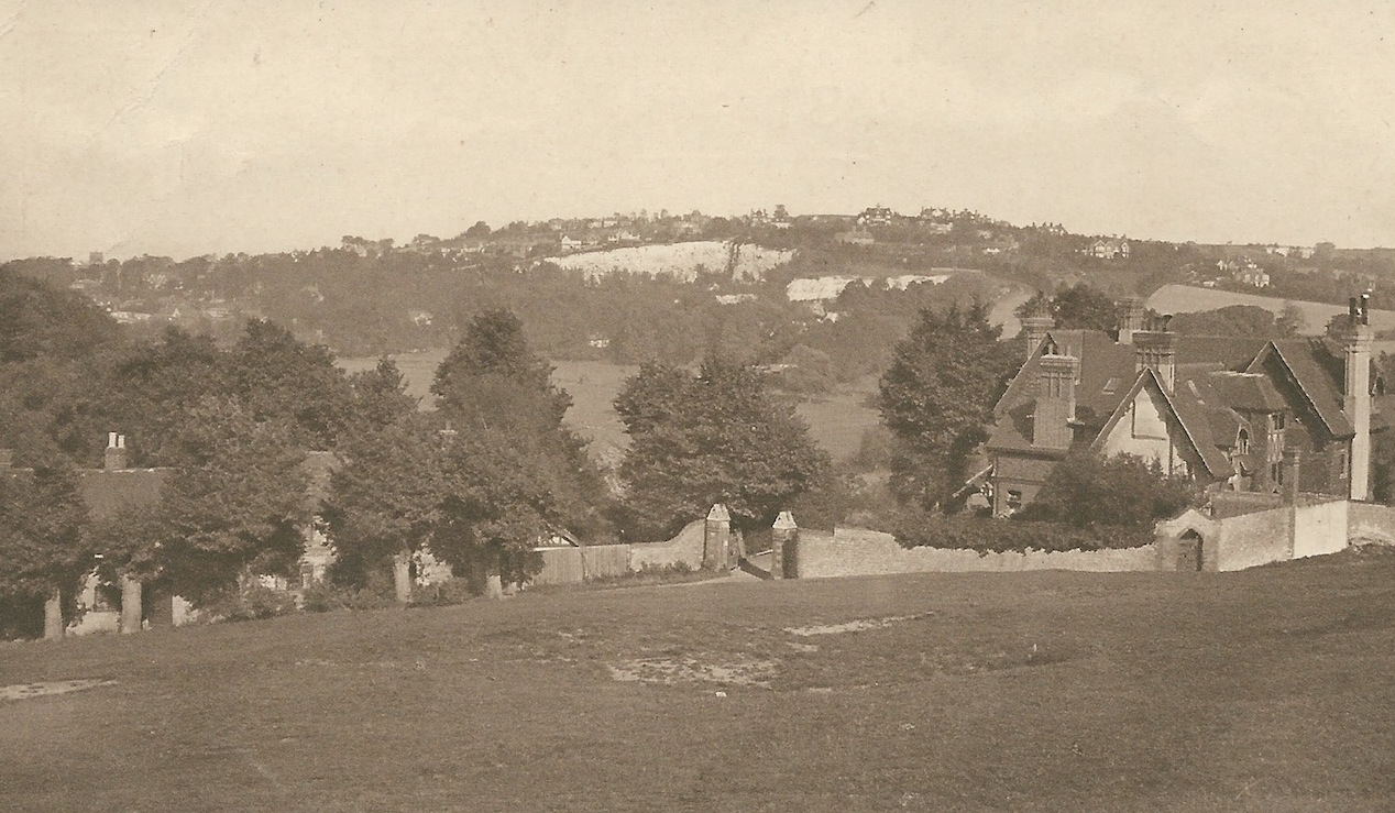
Where is this and what can be seen? Click on picture to enlarge in a new window.
The vintage picture is taken from a hilltop a short way from Guildford town centre. In the distance can be seen what was once a chalk quarry. The house on the right in middle foreground was destroyed by fire in about the 1970s, but the line of cottages (behind some trees) remain. So where was the photographer standing?
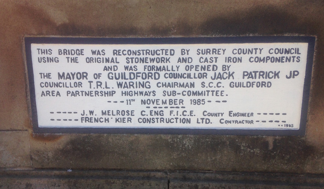
On which bridge can this plaque be found? Click on image to enlarge in a new window.
The quirky pictures shows a plaque that can found on one of the bridges in the town – but which one?
If you know the answers to this week’s mysteries, please leave a reply in the box below – and include extra details if you have them.
They will be published along with two more mystery images at about the same time next week. Good luck.
Also, reader Penny Tomkins has posted two replies to a story published some time ago titled Can You Help Solve Mysteries of Guildford School’s Histories, and asks for any photos of Westborough School.
I have now published a new story under our occasional heading ‘Were You There?’ that features images from my collection of Westborough School. Click here to view.
Do have a look and if you can name anyone, or can add details, please leave a reply in the box at the foot of that story.
Share This Post


Responses to Where Is This? No.223
Leave a Comment Please see our comments policy. All comments are moderated and may take time to appear. Full names, or at least initial and surname, must be given.

I'm living well for nothing at all! (See: No Trifling Matter: Magpie Trapped in Godalming Sainsbury’s)


Next stop, Debt Chasm! (See: We Should All Be Outraged About the Failure to Deal with Legacy Debt)


Dave Middleton
August 24, 2016 at 10:52 am
Sorry for not responding to last week’s W.I.T. Daily life got in the way!
This week’s townscape view is taken from the top of St Catherine’s Hill by the priory, looking across the river valley and Shalford Park at The Great Quarry, now called Chantry Quarry and containing some very exclusive dwellings. You can just spot the square tower of Holy Trinity Church on the skyline near the left of the picture.
The plaque is underneath Onslow Bridge on Bridge Street, on the east side of the river.
John Lomas
August 24, 2016 at 11:20 am
I think the old pic is St Catherine’s House looking approx NE towards Echo Pit and Pewley Down.
The bridge is Town Bridge at the bottom of the High Street
L Knight
August 24, 2016 at 1:33 pm
1) Could be from St Catherine’s Hill.
2) Town Bridge.
Sue Warner
August 24, 2016 at 3:24 pm
Just wild guesses here – St Catherine’s just above Ferry Lane.
Onslow Street Bridge, Guildford
Graham Clarke
August 25, 2016 at 3:01 pm
The view is from St. Catherine’s Hill, just down a little from the Priory, looking across towards Echo Pit Road/Warwick’s Bench area.
The plaque is to be found on the Town Bridge, bottom of the High Street.
Margaret Cole
August 30, 2016 at 9:27 am
The first picture is the view from St Catherine’s looking towards the Great Quarry on the Shalford Road just by Chantry View Road.
The plaque is on the Town Bridge in front of The White House pub.
I’ve had to get in early this week as I missed my correct replies last week, quick off the mark eh?
Bill and Doug Staniforth
August 30, 2016 at 5:06 pm
Picture 1 is taken from St Catherine’s looking towards Great Quarry. The house in the foreground was probably burnt down by a Mr M Giles to make way for his house or the view. [Some people would sue you for such a libellous comment. And stand up straight when you are reading this!]
Picture 2 is on the bridge at the bottom of the High Street.
More photos of bridges and rivers but still no prizes of fast river craft.
Chris Townsend
August 30, 2016 at 5:28 pm
The vintage picture was taken from St Catherine’s Hill, looking across Shalford Park towards Pewley Hill, before the Great Quarry was built on.
On the horizon I think I see Holy Trinity Church and Semaphore House.
The cottages are those just off Ferry Lane.
When St Catherine’s Tunnel collapsed in 1895, The Beacon had a narrow escape, though some of its outbuildings were lost; the house eventually succumbed to a fire and was demolished in 1975.
The plaque is on the Town Bridge, and commemorates its reconstruction after it was found to be unsafe. The iron bridge, first opened in 1902, replaced the old bridge which was badly damaged as a result of flooding in 1900.
Brian Holt
August 30, 2016 at 9:33 pm
This view is from the top of St Catherine’s Hill, behind the trees is Shalford Meadows, which was flooded in cold weather and you were charged to skate on.
The houses above the chalk quarry is in Warwick’s Bench Road. The house on the far right is The Beacon it was demolished in 1975 after a fire.
The plaque is on the High Street river bridge.