- Stay Connected

Socialize

 Abraham Lincoln
If given the truth, the people can be depended upon to meet any national crisis...
Abraham Lincoln
If given the truth, the people can be depended upon to meet any national crisis...

 Guildford news...
for Guildford people, brought to you by Guildford reporters - Guildford's own news service
Guildford news...
for Guildford people, brought to you by Guildford reporters - Guildford's own news service
Where Is This? No.242
Published on: 12 Jan, 2017
Updated on: 12 Jan, 2017
By David Rose
Thirteen replies, mostly all correct, to last week’s mysteries…
The vintage view was taken from Friary Street looking towards High Street with the construction of the Plummers Roddis building (now Debenhams) but before some of the other buildings were demolished to make way for Millbrook.
The ‘lions’ heads’ can indeed be found on the telephone exchange building in Leapale Road – but what they represent remains a mystery.
Click here for last week’s post and all the replies.
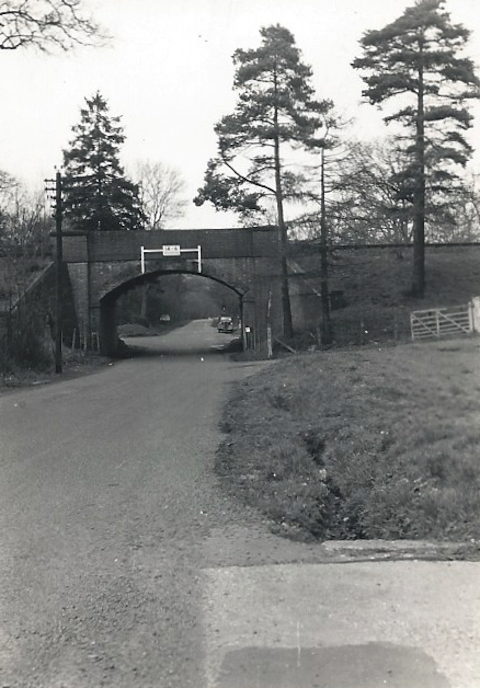
Where is this railway bridge?
This week’s mystery vintage picture is taken from a tiny print I have in my collection. I think I know the location. If I am correct the railway bridge is about 2.5 miles from Guildford town centre.
The road layout is much the same today. Away to the right is now a business park. Do you know where?

The place names on the sign may help identify its location.
The quirky picture of a wooden destination sign is in a village not far from Guildford.
If you know the answers to this week’s mysteries, please leave a reply in the box below – and include extra details if you have them.
They will be published along with two more mystery images in about a week’s time. Good luck.
Share This Post


Responses to Where Is This? No.242
Leave a Comment Please see our comments policy. All comments are moderated and may take time to appear. Full names, or at least initial and surname, must be given.

I'm living well for nothing at all! (See: No Trifling Matter: Magpie Trapped in Godalming Sainsbury’s)


Next stop, Debt Chasm! (See: We Should All Be Outraged About the Failure to Deal with Legacy Debt)


Harry Eve
January 13, 2017 at 7:15 am
I think the place names are in Albury. The railway bridge could be in Merrow – but that area looks very different now.
Nigel Durbridge
January 13, 2017 at 9:21 am
That looks like the bridge at the bottom of Merrow Street. Due to through road changes it will now have a different address.
C Barker
January 13, 2017 at 9:27 am
Park Lane, Merrow Lane and New Inn Lane junction in Merrow, looks exactly the same today with the exception of a set of traffic lights.
John Lomas
January 13, 2017 at 10:16 am
The bridge appears to be Merrow Lane viewed from the southern side.
The date is after the large scale 1935 OS map, because the entry where the photographer is stood does not appear on that map whereas it does appear on the 1964.
OS are usually very good with tree types but strangely neither of those maps show the conifers.
The priority at the junction beyond the bridge has been changed over the years. The priority route now bends to the left into New Inn Lane.
Where was the “Cow Book Ends” civic art when you took the picture in Albury? Compared with the current Streetview you must have been just about where it is shown.
David Wragg
January 13, 2017 at 11:18 am
I think the railway bridge might be on the road leading from Merrow to Burpham, with the road on the left running down to the roundabout at Burpham. The bridge carries the ‘New Guildford Line’ – in other words the Cobham line.
It is some time since I last used this road, so someone else might have a better idea.
Mike Dillon
January 13, 2017 at 1:20 pm
The bridge is, I think, Merrow street / Burpham Lane.
Dave Middleton
January 13, 2017 at 2:40 pm
The Bridge is over Merrow Lane, immediately prior to the junction with New Inn Lane, now controlled by traffic lights.
The quirky picture finger post is at the junction of Albury Street and Church Lane at Albury.
Mike Williams
January 13, 2017 at 5:01 pm
Until the business park was mentioned, I thought the railway bridge was at Worplesdon, but it’s not – it’s between Merrow and Burpham. After the bridge you turn sharp left for the Green Man roundabout.
Pratts Stores is at Albury. Hard to believe that the main A25 wound its way through all those villages for years. I wonder if there’s a photo of Mr Pratt somewhere.
Carol Norris
January 13, 2017 at 5:18 pm
Picture 1 : just before the sharp turning towards Burpham from Merrow.
Picture 2 : Albury village shop
Tony Oldland
January 13, 2017 at 11:22 pm
Bottom of Merrow Street under bridge goes into New Inn Lane.
Second picture is outside post office and shop in Albury.
Chris Townsend
January 15, 2017 at 12:50 pm
The bridge is across Merrow Lane, with New Inn Lane under the bridge and off to the left.
The signpost is on the village street at Albury, at the junction with Church Lane. The third pointer is to the church – the “new” parish church – and Weston Fields.
Bill and Doug Stanniforth
January 17, 2017 at 4:11 pm
The bridge is in Merrow Lane.
The sign is in downtown Albury close to the vast metropolis of Chilworth also near to the raging torrent of the River Tillingbourne.
Raging torrent? Sounds a suitable place for unwanted speedboaters. Ed
Brian Holt
January 17, 2017 at 8:36 pm
The bridge is in Merrow Lane , on the right is the entrance to the old Merrow sidings now an industrial park.
The signpost and Pratts Stores and post office is in Albury, and the part of the sign you cannot see is pointing to the church and Weston Fields.
Margaret Cole
January 19, 2017 at 11:38 am
The railway bridge is at the junction with Merrow Lane and New Inn Lane at Burpham.
The Tudor-style building is Pratts Stores, Albury, opposite Church Lane.