- Stay Connected

Socialize

 Abraham Lincoln
If given the truth, the people can be depended upon to meet any national crisis...
Abraham Lincoln
If given the truth, the people can be depended upon to meet any national crisis...

 Guildford news...
for Guildford people, brought to you by Guildford reporters - Guildford's own news service
Guildford news...
for Guildford people, brought to you by Guildford reporters - Guildford's own news service
Where Is This? No.244
Published on: 26 Jan, 2017
Updated on: 26 Jan, 2017
By David Rose
Plenty of correct replies to last week’s images, and a big apology to readers who have been following this column for a long while, as the vintage picture has been featured here before!
Some correctly pointed out my error in that the picture showing Chertsey Street and viewed from Martyr Road was seen here in Where Is This? No.104, back in April 2014.
I’ll blame late-night writing of this column last week after coming in from playing a gig with a band I’m helping out on a temporary basis. They’re called Squeezebox and we were playing at a pub called the Holly Tree in Addlestone.
However, I am sure the quirky picture has not been featured before and the 1996 date plaque can be found above the service entrance to the House of Fraser store in North Street.
Thanks to all who replied and you can see last week’s post here with all the comments.
Here at The Guildford Dragon NEWS we do welcome readers’ comments to this and all our stories, but may I remind you our policy is to print full names, or at least an initial of someone’s first name and then their surname. Thank you.
For this week’s mystery vintage picture, I am confident this actual photo has not been featured before.
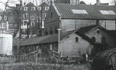
What can you say about this view?
It is quite small in size as it is cropped from the original picture, which itself is a fairly small print. You may be able to work out the location by some of the building that still stand, but what was the larger building seen coming in from the right?
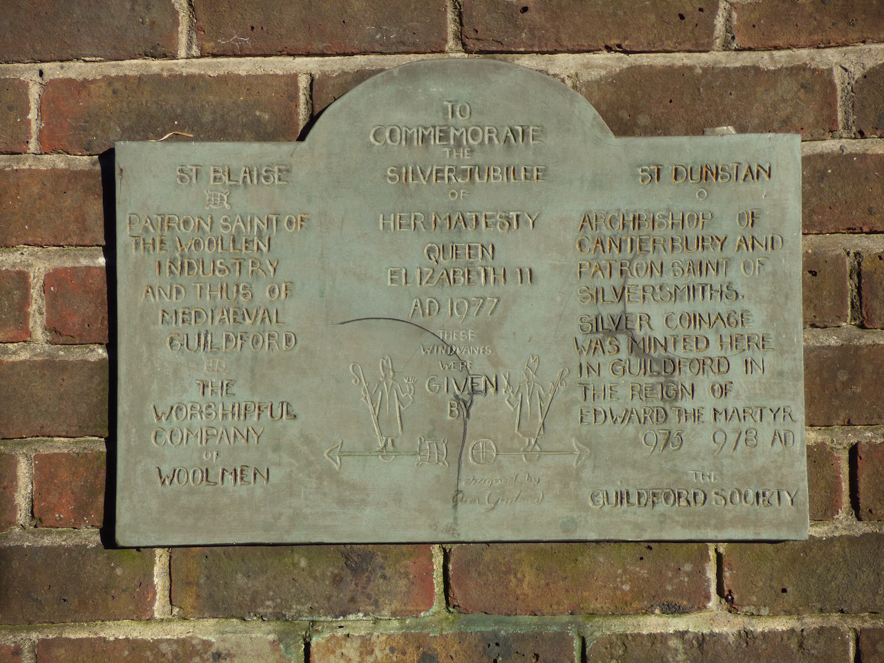
What’s this plaque all about and where can it be seen? Click to enlarge in a new window.
This week’s quirky picture is a plaque that can be found not far from the river in the centre of Guildford. Does anyone know where it is and what it is all about?
If you think you know the answers, please leave a reply in the box below. The answers, along with the next pair of images, will be published at about the same time next week.
Share This Post


Responses to Where Is This? No.244
Leave a Comment Please see our comments policy. All comments are moderated and may take time to appear. Full names, or at least initial and surname, must be given.

I'm living well for nothing at all! (See: No Trifling Matter: Magpie Trapped in Godalming Sainsbury’s)


Next stop, Debt Chasm! (See: We Should All Be Outraged About the Failure to Deal with Legacy Debt)


Jamie Smith
January 26, 2017 at 11:29 pm
Is it looking from Millmead car park, by the Britannia looking at Millmead Lock and the watersheds alongside the Yvonne Arnaud Theatre (which is now stood to the left off picture)?
The houses in the back are those accessed from Quarry Street.
John Lomas
January 27, 2017 at 12:36 am
I think the old picture is looking from the island between the river and Millmead Lock towards the foundry and in the background the backs of building on Quarry Street or possibly Mill Lane.
The iron structure in the right foreground being the footbridge over the lock.
I will hazard a guess that the jubilee plaque celebrating the importance of wool to the town and the pevious existence of the royal mint in Guildford is close to the site of the old Blackfriars friary.
Sue Warner
January 27, 2017 at 4:06 pm
These buildings were in Bedford Road, just to the left as you approach Walnut Bridge. It is a car park now.
Carol Norris
January 27, 2017 at 6:26 pm
Picture 1 : Buildings that used to be in what is now Millbrook opposite to the back of Quarry Street.
Dave Middleton
January 29, 2017 at 3:28 pm
Completely stumped on the silver jubilee plaque!
The old picture is taken from the Millmead side of the footbridge near the council offices, looking towards the passageway by the side of the Yvonne Arnaud Theatre.
The long single story building to the right is still there and is something to do with Thames Water.
Was the big building behind it once Guildford’s water works perhaps? It’s not there nowadays.
Chris Townsend
January 30, 2017 at 3:51 pm
The old photo shows the footbridge at Millmead Lock and the backs of houses on Quarry Street.
In the right-hand corner is part of the bridge over the river at Millmead.
On the left is part of the theatre, so the photo must be dated later than 1965.
The large building was a pumping station of the water works. I was told that the long low building was used at one time (1920s?) to house stray dogs, who would howl as people walked past.
Mike Dillon
January 30, 2017 at 4:26 pm
The photo was taken from Millmead looking towards Quarry Street.
I think the large building was a water works
Bill and Doug Stanniforth
January 31, 2017 at 4:58 pm
It’s Millbrook looking from the bridge in Millmead.
We think the building is the water treatment works near Keith Moon’s Timber Yard!
We don’t know where or what the plaque is but we’re certain it has nothing to do with speedboats.
Hooray!. But you’ll need to go to St Anne’s Hill near Chertsey to find the late Keith Moon’s former house. He, of course, was the great drummer in the rock band the Who. Ed
Brian Holt
January 31, 2017 at 9:40 pm
The picture was taken from Millmead, you can just see in the bottom right corner the end of the footbridge.
To the right of the lamp-post is Millmead Lock, the long building is the old stray dogs kennels, behind is the Thames Water building.
On the left the white building must be part of the old iron foundry which was demolished in 1941, then it was Millmead Monarchs Cycle speedway track, my local team.
The Yvonne Arnaud Theatre was built on this site 1965.
The big house is the back of what was British Legion Club in Quarry Street.
Margaret Cole
February 1, 2017 at 9:31 am
Their first picture is of the back in Quarry Street looking down on where the Filmer and Mason foundry used to be.
Therefore, the big building to their right may have been where the fulling mill was once, opposite the town mill.
Yvonne Arnold Theatre was built there in 1965.
The long low building of the lost dogs’ home is still there, next to Millmead Lock.
Second picture: no idea, looked high and low.
Chris Townsend
February 6, 2017 at 12:09 pm
Roger Nicholas’ excellent book “… And the Lord taketh away”, about the Mount Cemetery, has an item about Ann Garland, designer of the mystery wind vanes, according to the plaque. The book mentions wind vanes on the roof of the [former] Old People’s Centre, that’s beside the treadwheel crane, close to the plaque. Can someone confirm that they’re still there?